
A European-Union funded consortium invites companies and public agencies from North Africa and the Middle East to submit ideas for extending Galileo GNSS and EGNOS use in the region. Eligible ideas could be for a small pilot project or research study, a technical training plan, and/or a publication or article.
Mercedes-Benz Research & Development North America (MBRDNA) is working on a way to take advantage of the Google’s newest GPS-equipped device: Google Glass.
Space Exploration Technologies was awarded a launch reservation contract with MacDonald, Dettwiler and Associates Ltd. (MDA) to support the largest space program to date in Canada, carrying the three satellites to orbit that will make up the RADARSAT Constellation Mission (RCM) on a Falcon 9 rocket in 2018. RCM is a three satellite
The National Geographic Institute (IGN), the mapping agency of Peru, has launched a project for digitisation of national cartography. The idea of the project is to have a high precision data in order to contribute to the growth of public and private investments that can benefi t from this updated mapping information.

Uttarakhand is in absolute shambles. Disaster, with most people calling it more manmade than natural, has exposed the fragility of this beautiful yet ecologically vulnerable region. Untold and unimaginable damage has been done with surging rivers and flash floods bringing…

This section presents the structure of a mobile field robot, including a robotic base and an embedded circuit board design.

In order to solve the underlying problem, Korea MOLIT (Ministry of Land, Infrastructure and Transport) enacted a special act on cadastral resurvey, proclaimed this on 16 September 2011. With the implementation of this special act from 17 March 2012, a CRP (Cadastral Renovation Project) has been being promoted in earnest.

The Ashtech-branded GNSS boards and Integrator-ready GNSS receivers are now managed as part of the Trimble Integrated Technologies (OEM) business. That business sells not only GNSS technology but also digital radio technology and other integrator offerings including software and services. The Ashtech GNSS OEM portfolio nicely complements the existing Trimble “BD” range of GNSS boards, providing integrators with a wide range of options and capabilities to choose from.

In this first application of morphometrics to earthquakes, plot sequences are first provided for coordinate shifts, rotations, and uniform scaling on each separate day. In addition to those seven time histories from Procrustes representations,
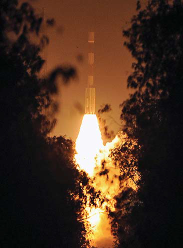
Finally, it happened on July 2, 2013.
India successfully launched IRNSS-1A
The fi rst satellite of Indian Regional Navigation Satellite System (IRNSS),


 (5.00 out of 5)