
International aid was meant to heal broken economies and build fairer societies. Yet decades and billions later, the results remain uneven, often entangled in politics, flawed incentives, and misplaced priorities. In this wide-ranging conversation with Coordinates, development economist Dr. Emily Brearley speaks about the moral contradictions of aid, the misplaced faith in technology, and what …

The analysis performed in this report is solely his work and own opinion. State Program: U.S.A (G); EU (E); China (C) “Only MEO- SECM satellites”; Russia (R); Japan (J); India (I)
Narayan Dhital
Actively involved to support international collaboration in GNSS related activities. He has regularly supported and contributed to different workshops of the International Committee on …

This article describes how cadastral surveying and mapping have developed in Norway, the background to the introduction of an authorization system, how the new authorization system will be organized, and the status of issuing surveyor’s certificates.
Leiv Bjarte Mjøs
Dr. Philos., Professor, Department of Civil Engineering and Environmental Sciences, Western Norway University of Applied Sciences
Abstract
After January 1, …

The research contributes to the optimization of cadastral processes and highlights the importance of selecting appropriate GNSS techniques based on factors such as distance to CORS and traceability requirements.
Assoc. Prof. Sr. Dr Tajul Ariffin Musa
Faculty of Built Environment and Surveying, Universiti Teknologi Malaysia, 81310 Johor Bahru, Johor, Malaysia
Nur Alyya Nordin
Faculty of Built Environment and Surveying, …
Volume 21, Issue 10, October 2025
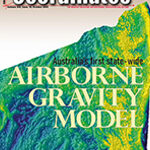
Australia’s first state-wide airborne gravity model
Volker Janssen, Thomas Grinter and Maria Jansen
Landslide vulnerability mapping for Himachal Pradesh
Satish Kumar Negi and Shashi Shekhar
GNSS Constellation Specific Monthly Analysis Summary: September 2025
Narayan Dhittal
My Coordinates
EDITORIAL
News
GIS | IMAGING | GNSS | INDUSTRY
CALENDAR
November 2025 – May 2026
Advertisers in this Issue :
SBG …
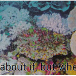
The Global Tipping Points Report 2025, Prepared by the Global Systems Institute at the University of Exeter, With the participation of 160 scientists, Warns that Earth has crossed its first climate tipping point.
Coral reefs, once radiant ecosystems, Are collapsing under relentless ocean heat.
Their bleaching is …
November 2025
Canada’s National Geomatics Expo 2025
3 – 5 November
Calgary, Canada
https://gogeomaticsexpo.com
13th International FIG Workshop on the Land Administration Domain Model & 3D Land Administration
3 -5 November 2025
Florianópolis, Santa Catarina, Brazil
https://gdmc.nl
Trimble Dimensions
10-12, November …
New UltraCam Dragon 4.2 unveiled
Vexcel Imaging unveils the new UltraCam Dragon 4.2, the next evolution in hybrid aerial mapping technology. The new system features a significantly larger nadir and oblique image footprint, delivering a performance boost with 35% more flight line efficiency for faster data collection. Its powerful sensor suite combines two nadir cameras (RGB …
Study on GNSS authentication and security improvements
The E-GIANTS (European GNSS Improved Authentication Solutions) project was commissioned by the European Commission and technically supervised by EUSPA. The project responds to the growing threat posed by quantum computing to traditional cryptographic methods, which could compromise the security of GNSS services in the coming decade. The study highlights …


 (5.00 out of 5)