| Surveying | |
Australian Height Datum: Saving AHD in New South Wales
The Australian Height Datum (AHD) celebrates its 50th anniversary this year. This paper outlines the datum maintenance and modernisation efforts undertaken in New South Wales (NSW) to not only preserve but improve access to AHD |
 |
|
 |
|
The Australian Height Datum (AHD) is Australia’s first and only legal vertical datum, celebrating its 50th anniversary this year. The adjustment of the Australian National Levelling Network (ANLN) in May 1971 provided, for the first time, a nationwide network of physical AHD heights (Roelse et al., 1975). For most spatial professionals, AHD has been ubiquitous for the entire duration of their careers, being the vertical datum of choice because it was the only one. In a previous paper published in May 2021 issue of Coordinates magazine, we celebrated the achievements and longevity of AHD, outlined its shortcomings and looked ahead to a new era of vertical datum determination, culminating in the Australian Vertical Working Surface (AVWS, see ICSM, 2020a) as an alternative for those who need it.
DCS Spatial Services, a business unit of the NSW Department of Customer Service (DCS), is responsible for the maintenance of the NSW survey control network. Relevant information is made available via the Survey Control Information Management System (SCIMS), the state’s database containing about 250,000 survey marks on public record (Janssen et al., 2019). This paper describes the datum maintenance and modernisation efforts undertaken by DCS Spatial Services through its ongoing Saving AHD projects. As AHD is showing its age and slowly deteriorating, these projects aim to not only preserve but improve access to AHD.
Present challenges
One important issue affecting the availability of AHD is mark destruction. Despite the best efforts in the Preservation of Survey Infrastructure (POSI, see DCS Spatial Services, 2020), entire sections of original ANLN spirit-levelled AHD have been destroyed. Mark destruction is far higher in eastern NSW, with some level runs completely lost in city regions or along highways. In rural and remote areas, marks often still exist but can be difficult to find due to the removal of all physical connections listed on locality sketch plans (e.g. road mile posts, telegraph lines and relocated fences or gates) and road realignments, which alter chainages or deviate far from the original road corridors.
Fortunately, many ANLN marks previously identified as destroyed or not found in SCIMS are being successfully recovered in good condition, maintained and upgraded using Geoscience Australia’s free online GPS processing service, AUSPOS (see Janssen and McElroy, 2020; GA, 2021). On some level runs, DCS Spatial Services field crews report a recovery rate of 20% or better for lost marks. Finding marks that had reference blazes cut on trees is even more successful.
Another challenge is mark movement. How well has the mark been able to hold its initial AHD height over 50 years? Thankfully, Australia enjoys rather stable tectonics, where vertical movements are generally infrequent and not substantial. However, there are exceptions, most notably in subsidence areas caused by mining, major construction activities or reactive soils.
While AHD has been lost in regions of reactive black soil and any new value would soon be invalid following the next wet or drought season, problems also occur in less obvious regions. A recent investigation into a height anomaly of about 0.14 m at the NSW-Victoria border revealed that issues arise with constraining ANLN junction points when new levelling observations are taken between them. Allowing for apparent mark instability at one junction point and using the new levelling data resulted in the discrepancy to be reduced by more than 50% (Watkins et al., 2017). Such mark movement supports the notion that, after several years, first-order levelling surveys may deteriorate to much the same order of accuracy as third-order levelling, which becomes apparent when runs are re-levelled (Lambert and Leppert, 1976).
The next challenge for AHD is technology itself. The era of Global Navigation Satellite System (GNSS) technology led to the development of geoid or quasigeoid models to convert GNSS-derived ellipsoidal heights to physical heights, including the current AUSGeoid2020 for Australia (e.g. Brown et al., 2018; Janssen and Watson, 2018; Featherstone et al., 2019). Particularly over longer distances, this has made height determination and transfer more efficient than with the traditional techniques employed in the 1970s and 1980s.
While the role of DCS Spatial Services is to maintain NSW’s survey control network, in the last 10 years it has taken on a more active role in both POSI and its effort towards saving AHD. To this end, several projects have been undertaken.
Tide gauge monitoring
AHD was constrained by 30 tide gauges. Over the years, DCS Spatial Services has continued to monitor the stability of tide gauges via precise optical levelling, then digital levelling and recently precise EDM height traversing. Generally conducted every two to five years, these surveys monitor the stability of the tide gauge compared to a near array of stable survey marks. Port Kembla tide gauge has been regularly monitored for over 20 years, while Fort Denison tide gauge has been resurveyed across 600 m of water from the island in Sydney Harbour to Mrs Macquarie’s Point (and then back to the survey plug installed in 1882 on the external wall of the former Department of Lands building). More recently, Eden tide gauge has been similarly connected.
Five GNSS Continuously Operating Reference Stations (CORS) were either specifically built or adopted to augment long-term monitoring of tide gauges located along the NSW coast in order to support sea-level studies: Fort Denison, Port Botany, Newcastle East, Port Kembla and Eden (Janssen et al., 2013). This helps answer the question “Is the sea level rising or the land falling, or both?”
Sampling ANLN level runs with AUSPOS
AHD is not homogenous. While multiple ANLN level runs may meet at a junction point, each has its own characteristics. Level runs may include (positive or negative) systematic errors, one-foot blunders, and may have been subject to mark movement over the last 50 years. Transferring or linking AHD heights from different ANLN runs can lead to serious complications. Sampling can model these issues.
In a dedicated large-scale effort, AHD marks were sampled across NSW, as quickly as possible, for improvement of the national AUSGeoid model. This was conducted in a series of Saving AHD AUSPOS survey campaigns, starting in 2015.
In the first pass, every level run was investigated and sampled, generally during a single field day with five to six GNSS receivers deployed over the length of the level run. Each mark was maintained (i.e. cleared, painted, and protected using generally three painted star pickets), photographed, observed by an overnight AUSPOS session, and SCIMS was updated with current metadata.
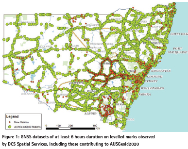
As part of NSW’s contribution to the development of AUSGeoid2020, DCS Spatial Services collected more than 2,500 extended GNSS datasets (at least 6 hours but generally 12-24 hours duration) on levelled benchmarks for AUSPOS processing. These GNSS datasets informed the geometric component of AUSGeoid2020, helping to provide a much better connection to AHD (Janssen and Watson, 2018). For many of these old benchmarks, GNSS also improved their horizontal position, which was initially obtained by scaling off a map, often resulting in positioning errors of several hundred metres. This not only improved user access, but also allowed preservation efforts to be undertaken (you can only protect a mark if you know where it is).
Observing FBMs and GBMs with AUSPOS
Meanwhile, a dedicated campaign is underway to find, maintain and collect AUSPOS datasets on Fundamental Bench Marks (FBMs) and Geodetic Bench Marks (GBMs), which were installed in the 1970s. These high-stability marks were specifically designed to maintain height, whether it be AHD, ellipsoidal or even AVWS height.
Recovering lost levelling
DCS Spatial Services has invested significant resources over the last few years in trying to recover lost levelling, e.g. first-order levelling from the Snowy Mountains Hydro-Electric Authority (SMA). This included approximately 1,000 marks over 1,000 km from Cooma to Tumut and on to the Victorian border, surveyed in the days of the Snowy Mountains Hydro-Electric Scheme (construction from 1949 to 1974). To date, nearly 15% of these marks have been recovered, maintained and observed. This is a great result, considering that SCIMS basically held no levelled heights in Kosciuszko National Park and these marks are now 70 years old.
Similarly, we continue to recover, on an ad-hoc basis, 1950s National Mapping Division levelling. This data is predominately located in remote regions, with level runs reaching out to a graticule of 1° map corners that are often located in the middle of an outback paddock.
DCS Spatial Services was also planning to recover Rural Bench Marks (RBMs), installed by the Australian Capital Territory (ACT) at the same time AHD was being observed. While about 450 of the 1,200 RBMs are located in NSW, only a handful are included in SCIMS. A planned joint project with the ACT Office of the Surveyor-General to recover these RBMs was cancelled in 2020 due to the COVID-19 pandemic. It has now been pencilled in for the 2021/22 financial year.
High fidelity (HiFi) saving AHD
In the Central West, DCS Spatial Services is nearing completion of its HiFi Saving AHD project. In this area, every rural ANLN mark has been searched for, then maintained and upgraded. To date, approximately 1,200 km of levelling has been audited and surveyed, while another 400 km is planned. The number of recovered ANLN marks has exceeded expectations, with evidence that some have been used by other surveyors. While it is fortunate to recover these marks, it is disappointing that surveyors have not reported these finds, so they can be shared for everyone’s benefit. This project may be expanded to other parts of the state.
Overall, the ongoing Saving AHD campaigns have to date yielded 900 additional extended GNSS datasets on levelled benchmarks since the computation of AUSGeoid2020 (Figure 1). While the Intergovernmental Committee on Surveying and Mapping (ICSM) currently does not plan to update AUSGeoid2020 into the future, these datasets will be very valuable for the continuing improvement of AVWS.
Digitising historical levelling records
In NSW, AHD is simply a set of numbers printed on some 3,600 cardboard sheets, which are now safely stored in State Archives. These levelling cards summarise each level run and are abstracts of the original field notes, detailing the measured and adjusted height differences between benchmarks and junction points. At some stage, these AHD values were manually typed into SCIMS (naturally including unknown typos associated with all manual data entries), and an electronic master version does not exist. Despite the efforts by academics and federal agencies over the years, the original AHD values cannot be reproduced. The value on the card is AHD, for better or worse.
These historical levelling cards are progressively being preserved and digitised. First, they were scanned and safely archived in a digital environment. Optical Character Recognition (OCR) failed to convert these files to smart digital files, so each card was then manually converted to Excel files (one per level run). Quality assurance of this laborious manual data entry process is currently underway. Once complete, the values in SCIMS can themselves be checked to remove any typos that have lain dormant for decades.
Building the NSW levelling adjustment
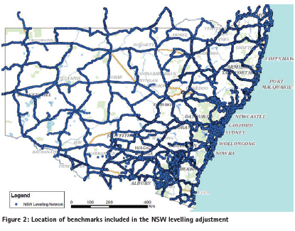
Together with the results of data-mining existing levelling files in the DCS Spatial Services archive, the digitised historical levelling data is being used to generate a single, state-wide levelling adjustment for NSW. Currently, it comprises about 132,000 measurements and 98,000 stations (Figure 2). While still underway, the enormity of this task and its benefits to the profession should not be underestimated. Victoria has already completed a state-wide levelling adjustment, and other jurisdictions are now also starting similar projects.
It should be emphasised that there are no plans to readjust (or re-realise) AHD. Under the original rules, jurisdictions cannot modify the height of junction points without federal approval. The height of intermediate marks can be updated if a blunder or mark movement is detected and proven, which is part of the day-to-day maintenance.
Ongoing datum modernisation in NSW
DCS Spatial Services is responsible for the maintenance of the NSW survey control network. Datum modernisation and further improvement of survey infrastructure is required to accommodate the increasing accuracy and improved spatial and temporal resolution available from modern positioning technologies to an ever-broadening user base.
This has led to the establishment of CORSnet-NSW, Australia’s largest state-owned and operated GNSS CORS network (e.g. Janssen et al., 2016; DCS Spatial Services, 2021). CORSnet-NSW is not only the backbone of the Geocentric Datum of Australia 2020 (GDA2020, see ICSM, 2020b) across the state but also provides fundamental positioning infrastructure that is authoritative, accurate, reliable and easy-to-use for a wide range of applications. Furthermore, with all sites contributing to AUSPOS, it comprises a fundamental, high-density and long-term component of AUSPOS infrastructure within NSW (Janssen and McElroy, 2020).
Consequently, the use of AUSPOS campaigns has developed into a capable and reliable alternative to conducting traditional static GNSS baseline surveys, simplifying field work logistics and reducing processing times. This has substantially accelerated the process of including additional survey marks into the GDA2020 state adjustment to improve user access to GDA2020 coordinates and uncertainties on public record through SCIMS (e.g. Gowans et al., 2015; Janssen and McElroy, 2020). AUSPOS has become the primary survey technique used by DCS Spatial Services to preserve AHD.
DCS Spatial Services is currently building an updated passive survey control network (in the Eastern and Central Divisions) with a minimum of one fundamental survey mark observed by 6+ hour AUSPOS every 10 km. Its vision is to ensure that any future user is no further than 5 km (and often much less) from such a fundamental mark providing direct connection to datum. Similarly, levelled AHD marks are observed by 6+ hour AUSPOS every 10 km, often at a far greater density. This will allow users to achieve DCS Spatial Services’ vision of a Positional Uncertainty of 20 mm in the horizontal and 50 mm in the vertical (ellipsoidal height) component anywhere in the state and easily apply transformation tools to move between current, future and various historical datums and local working surfaces.
Conclusion
As AHD celebrates its 50th anniversary this year, this paper has outlined the datum maintenance and modernisation efforts undertaken in NSW to not only preserve but improve user access to AHD. Through its Saving AHD projects, DCS Spatial Services helps ensure that users have continued and easy access to AHD, while also providing a solid foundation for the continuing improvement of AVWS as an alternative for those requiring higher-quality physical heights.
There can be only one legal vertical datum, and currently there is no planned push to replace AHD. DCS Spatial Services has yet to implement AVWS but continues to investigate and contribute towards it. Our ongoing Saving AHD projects ensure that users have access to their vertical datum of choice. These efforts may also help AHD celebrate more milestones in the future.
References
Brown N.J., McCubbine J.C., Featherstone W.E., Gowans N., Woods A. and Baran I. (2018) AUSGeoid2020 combined gravimetric-geometric model: Location-specific uncertainties and baseline-length-dependent error decorrelation, Journal of Geodesy, 92(12), 1439-1456 & 1467.
DCS Spatial Services (2020) Surveyor-General’s Direction No. 11: Preservation of Survey Infrastructure, https://www.spatial.nsw.gov.au/surveying/surveyor_generals_directions (accessed Apr 2021).
DCS Spatial Services (2021) CORSnet-NSW, http://www.corsnet.com.au/ (accessed Apr 2021). Featherstone W.E., McCubbine J.C., Claessens S.J., Belton D. and Brown N.J. (2019) Using AUSGeoid2020 and its error grids in surveying computations, Journal of Spatial Science, 64(3), 363-380.
GA (2021) AUSPOS – Online GPS processing service, http://www.ga.gov.au/scientific-topics/positioning-navigation/geodesy/auspos (accessed Apr 2021).
Gowans N., McElroy S. and Janssen V. (2015) Survey infrastructure preservation and upgrade: Trigonometrical stations in NSW, Proceedings of Association of Public Authority Surveyors Conference (APAS2015), Coffs Harbour, Australia, 16-18 March, 67-84.
ICSM (2020a) Australian Vertical Working Surface (AVWS) technical implementation plan, version 1.3, https://www.icsm.gov.au/publications/australian-vertical-working-surface-technical-implementation-plan-v13 (accessed Apr 2021).
ICSM (2020b) Geocentric Datum of Australia 2020 technical manual, version 1.5, https://www.icsm.gov.au/gda2020-and-gda94-technical-manuals (accessed Apr 2021).
Janssen V., Commins R., Watson P. and McElroy S. (2013) Using GNSS CORS to augment long-term tide gauge observations in NSW, Proceedings of Surveying and Spatial Sciences Conference (SSSC2013), Canberra, Australia, 15-19 April, 12pp.
Janssen V., Gowans N., Hine S. and McElroy S. (2019) Removing the uncertainty surrounding Positional Uncertainty and Local Uncertainty in SCIMS, Azimuth, 58(8), 28-32.
Janssen V., Haasdyk J. and McElroy S. (2016) CORSnet-NSW: A success story, Proceedings of Association of Public Authority Surveyors Conference (APAS2016), Leura, Australia, 4-6 April, 10-28.
Janssen V. and McElroy S. (2020) AUSPOS and CORSnet-NSW: A match made in heaven, Coordinates, 16(7), 29-35.
Janssen V. and Watson T. (2018) Performance evaluation of AUSGeoid2020 in NSW, Proceedings of IGNSS Symposium 2018 (IGNSS2018), Sydney, Australia, 7-9 February, 15pp.
Lambert B.P. and Leppert K. (1976) A study of the Australian national levelling survey, Australian Surveyor, 28(2), 89-95.
Roelse A., Granger H.W. and Graham J.W. (1975) The adjustment of the Australian levelling survey 1970-1971, Technical Report 12 (2nd edition), Division of National Mapping, Canberra, Australia, 109pp.
Watkins D., Janssen V., Woods A. and Grinter T. (2017) Investigating an anomaly in the Australian Height Datum at the NSW-Victoria border in Barham/Koondrook, Proceedings of Association of Public Authority Surveyors Conference (APAS2017), Shoal Bay, Australia, 20-22 March, 48-67.


 (1 votes, average: 1.00 out of 5)


Leave your response!