| Mycoordinates | |
Urban Information Systems for Planning
|
|||||||||||||||||||
|
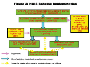
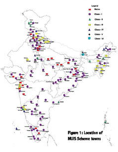
State of the art global communication technologies and thriving economy is facilitating Indian cities to compete in the global environment. The constant transformation of urban areas into complex entities has brought forth new challenges and opportunities for Planners to design and implement a variety of activities in spatial terms. There is need to tread common ground so as to address problems and issues in the right perspective to assist cities in coping with economic realities and thereby produce high quality responsive environment and demonstrate successful urban solutions. As per 2001 Census, India has 4378 Urban Agglomerations comprising of 5161 towns and cities. The number of Urban Agglomerations has grown from 3697 in 1991. These are confronted with problems of diffused and disorderly growth, ineffi cient public transportation systems, the conversion of agricultural areas into urban uses, governance etc. Above all, only about a third of the towns and cities The National Urban Information System (NUIS) has a total outlay of Rs. 66.28 Crore. This Scheme has taken all the States on board and 75% of the cost is borne by Government of India and remaining 25% is State matching contribution. NUIS Scheme consists of two components dealing with Spatial and Attribute data i.e. Urban Spatial Information System (USIS) and National Urban Data Bank and Indicators (NUDB&I) under a common umbrella. Urban Spatial Information System (USIS) has the major objective to meet the requirements of urban planning in the existing organizational set up under the State Town and Country Planning Departments (State Nodal Agencies). The basic spatial data such as base map, land use map and thematic maps generated may be used by various city governance/ management departments as well as for further generation of derivative themes/sector specifi c information e.g. utilities, infrastructure etc. Some of the main sources of spatial data for base maps and land use maps would be from remotely sensed sources such as CARTOSAT- I and aerial photographs, which would be used for integration with conventional maps. A National Urban Databank and Indicators (NUDB&I is to be set up within each State Town and Country Planning Department (SNA), which would develop town level urban database in general and databases for NUIS Scheme towns (ULBs) in particular. The focus of the database would be primarily to address the urban planning and management functions of the various departments. The data would be collated from the respective Urban Local Bodies and Statistical departments etc. In the fi rst instance, on pilot basis, 137 towns/cities (Figure 1) have been identified in consultation with respective State Governments for generation of spatial and attribute databases. The main thrust of the Scheme is to use modern data sources such as Satellite and Aerial platforms to generate a comprehensive 3-tier GIS database in the scales of 1:10000 for Master Plan preparation, 1:2000 for detailed town planning schemes and 1:1000 for Utility Mapping. Utility Mapping, especially for water supply and sewerage, will be captured by using Ground Profi ling/ Penetrating Radar (GPR) technology. High-resolution, multi-spectral satellite images (mono & stereo) will form the core of the 1:10000 scale mapping and Aerial photographs and Ground Survey (Total Station) for towns with area below 25 Sq. Kms. will be the main source for 1:2000 scale mapping. Ground Penetrating Radar (GPR) will form the input for mapping underground utilities. The GPR survey will be carried out in selected towns for the core areas. The images for mapping will be corrected/registered using Global Positioning System (GPS), or in other words, Ground Control Points Library (GCPL), and used for geometric correction of the images. For this, SOI is permanently constructing at least ? ve Ground Control Points in each of the 137 NUIS towns. Geographical Information System (GIS) will form the core of NUIS Scheme and will be used to prepare digital databases. The GIS application will be used to develop customized packages to generate outputs required for urban planning and management along with standardized GIS-based application packages that will allow users in Towns/States to extract speci? c inputs for planning. Attribute databases under NUDB&I components are also in sync with USIS. The NUDB&I databases for each town to support planning and management in relation to actual departmental functions, as identifed in Design and Standards document, will be generated/compiled by the ULB to be linked to the spatial database. The data so generated will be processed to derive indicators. Indicators extracted will be aggregated at the national level to support country level urban indices, in turn, to be transmitted to UNCHS. Capacity building/training has also been inbuilt in the Scheme with the view to expose decision makers, supervisory staff and operators to the whole range of issues dealing with spatial and attribute data. The underlying notion is that planning and decision support is required to be based on accurate database with provision for periodic updating. As part of the Capacity Building/Training schedule, TCPO envisages organizing about 30 training programmes and train about 600 administrators/planners/planning personnel over a 2-year period. As this is the Knowledge Age, the main aim of the NUIS capacity building programme is to develop skills of town planning personnel to tackle the real world problems. The main players in project implementation are TCPO under the Ministry of Urban Development, State Town and Country Planning Departments, Local Urban Bodies, Survey of India and National Remote Sensing Agency. The Mission Directorate is in TCPO, the nodal agencies are the State Town & Country Planning Departments. The Scheme management structure comprises of Technical Advisory Committee, NUIS Scheme Secretariat in TCPO, NUIS Scheme Technical/Standards Committee, NUIS Scheme Project Director at each State and NUIS Scheme project team at each Urban Local Bodies (Figure 2). In later phases, the Scheme will be scaled up to cover all 5161 towns/cities. TCPO is the nodal agency for appraising the progress and status of the Scheme from time to time for which a Technical Advisory Committee comprising of representatives of State Governments, NIC, ISRO, NRSA, and SOI has been constituted. |
|||||||||||||||||||
|
|||||||||||||||||||
|


 (1 votes, average: 2.00 out of 5)


