| SDI | |
When two do the same thing
View of the European directive INSPIRE and the implementation of its
|
 |
|
In 2014, the INSPIRE Directive had its seventh birthday and is undergoing revision. During those seven years the Directive and its regulation were implemented into the national law of the EU states. Additions were made as well as numerous technical guidelines (TG) and other documents, which were designed to better explain individual requirements and assist in their implementation. These documents have recommendatory character. Despite this fact, the question arises ‘Has INSPIRE clearly defined rules?’
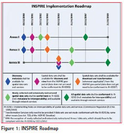
If we look at the INSPIRE Roadmap (Figure 1) [1], we can see that individual Member States, or more precisely their compulsory organizations should have metadata currently available for all themes of Annexes I, II and III, as well as for different types of services. Metadata should be discoverable through the discovery service. The data should be already available through view, download and transformation services that must already be in accordance with Commission Regulation (EC) No. 976/2009 of October 19, 2009, implementing Directive 2007/2/ EC of the European Parliament and of the Council as per the Network Services (EC No. 976/2009) [2]. It should be borne in mind also that the data may not currently be in accordance with Commission Regulation (EU) No. 1089/2010 of November 23, 2010 implementing Directive 2007/2/EC of the European Parliament and of the Council with regard to interoperability of spatial data sets and services (EU No. 1089/2010) [3].
Considering this fact, we would like to point out some differences in the different interpretations of individual requirements for the provision of data through the view services. Individual samples/ demonstrations will cover selected themes of Annex I of the INSPIRE Directive, especially in the area of Central European countries. Individual view services were connected to the Map client ZBGIS® (https://zbgis.skgeodesy.sk/tkgis/ Default.aspx?lang=en) of the national mapping and cadastral agency (NMCA) in the Slovak Republic (SR) – Geodesy, Cartography and Cadastre Authority of the Slovak Republic (GCCA SR).
One of the themes of Annex I is Geographical Grid Systems (GGS). An interesting aspect of this theme is that TG itself says, “Geographical grid systems (hereafter: Grids) play a specific role that is quite different from the other themes in the Directive’s annexes. Contrary to the other themes, the Grids’ specification does not concern a downloadable or viewable thematic data set.” [4]. Despite this fact, Slovakia (SR) and the Czech Republic (CZ) provided view services. Here, attention should be drawn to the fact that services were published before receiving the final versions of TG for the themes of Annexes II and III. Today, we know that this theme has a link with the theme of statistical units (SU). Looking at Figure 2, we can see several differences.
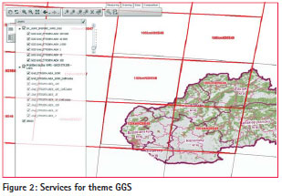
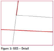
Cartography of single cells is different. SR has brown and CZ has red cells for the same layer. The explanation is simple – TG itself does not have a chapter portrayal like other TG. In practice, it means that if individual organizations are providing these data, they can also design their own cartography, which could be confusing for users (Cartography is defined in the TG for theme SU). Furthermore, we can see that different services have different names of layers, and in addition, the Czech service provides the names of the cells. In a more detailed preview, we can see, that Czech service has ‘gaps’ in geometry, i.e., lines are not closed (Figure 3).
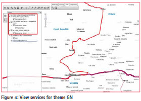
In case of another theme, i.e., Geographical Names (GN), the situation is somewhat different. The structure of layers is substantially the same, the difference is in the languages (Figure 4). Slovak and Czech services have the names of layers in the English language, while Poland used their national language. Regarding cartography, TG says, “All names (i.e., all spellings of all names of the named place) are displayed in black, with font Arial 10 pt, and located in order to touch the geometry of the named place, at its centre if possible.” [5] Comparing the Czech and Slovak services, names are placed in the middle of reference point of the name, and the font is slightly different. If we look at the Polish service, the name is located to the right of the reference point and the font name coincides with Slovak.
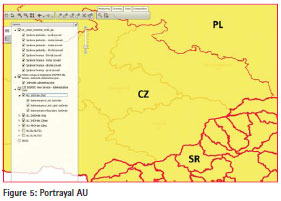
Another theme of Annex I of the INSPIRE Directive is Administrative Units (AU) [6]. At first sight it is evident to the user (Figure 5) that the structure of layers for each service is different. Slovak service provides four layers of administrative units and four layers of administrative boundaries – state, region, district and municipality). Similarly, it is the Czech service that additionally provides the name of the administrative unit. Polish service provides only one layer, namely administrative units for the state level (The theme AU was by Commission Regulation (EU) No 1253/2013 of 21 October 2013 amending Regulation (EU) No 1089/2010 implementing Directive 2007/2/EC as regards interoperability of spatial data sets and services changed, where feature NUTSRegion was removed.). Other differences include the language used. In this case, three different languages were used – English, Slovak and Polish. In case of cartography, there is compliance with all services, but the difference occurs at the scale denominator restrictions. Figure 5 provides preview into data at a scale 1:1000000, where the Slovak service displays data up to the district level, and the Czech service only to the region level. Poland has only one layer.
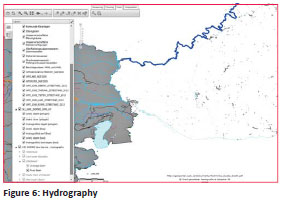
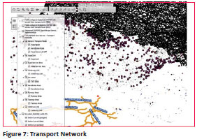
Other themes of Annex I of the INSPIRE Directive are still more complicated. Concretely, it is Hydrography (HY) [7], Figure 6 and Transport Network (TN) [8], Figure 7. Even with these themes it can be stated that the differences found in the previous themes are repeated here again – be it diversity in layers, languages, cartography or restrictions for scale denominators. In case of TN theme, four languages are used (English, Polish, Slovak and German). Slovak service provides only three layers that display information based on their geometry – polygons, lines and points. From individual layers it is not possible to find out what a particular feature it is.
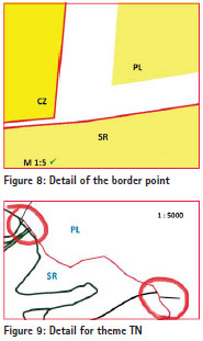
The following examples depict the situations at small scales. But how does it look in detail, at the borders of states? Figure 8 shows the point at the border of three countries at a scale 1:5 (difference between Slovakia and the Czech Republic is about 2 cm and between Slovakia and Poland approximately 20 cm).
Figure 9 at a scale of 1:5000 shows an example at the border between Slovakia and Poland for the theme TN. Here it is evident that when single lines are connected, shifts occur. In the upper left corner we can see that the roads have not continued on the Polish side, or more precisely if it is a road from the Polish side (different cartography), so there is a shift. In the lower right corner the shift is also evident. Is it a railway feature that continues to Poland?
Many similar examples can be found, of course, also in the Hydrography theme.
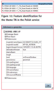
Another good example of how various organizations joined the publishing of view services is their different possibilities of the identification of features. Requirements for INSPIRE view services are based on EC No. 976/2009 [2] and on the OGC OpenGIS Web Map Service (WMS) Implementation Specification, version 1.3.0, more precisely ISO 19128:2005 Geographic information – Web map server interface. If you look through these requirements, you find out that GetFeatureInfo operation is not required. In case of INSPIRE view services provided by GCCA SR, this is indeed the case. GetFeatureInfo operation is not supported, which means that the user does not obtain the required attributes of the feature. Seen from this perspective, this information is quite interesting, if we take into account the requirements of EU No. 1089/2010 [3] for individual themes, their features and attributes items. But on the other hand, the user may not get to them via view services. Reasons for not providing information about features can be various – from insufficient hardware (HW) of the organization (it is an additional HW workload and the service might not meet the performance requirements), to the licensing policy of the organization (services with attributes are charged). It must be said that this is not so in general. Czech and Polish services support GetFeatureInfo operation, but the difference occurs with the attributes provided (Figure 10 and 11).
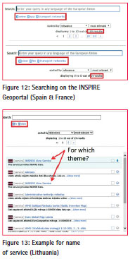
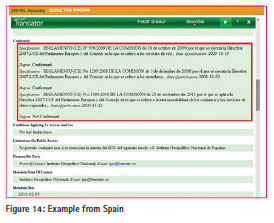
As we have stated at the beginning of this paper, at present also metadata for services must be provided in accordance with Commission Regulation (EC) no. 1205/2008 of December 3, 2008 implementing Directive of the European Parliament and Council Directive 2007/2/ EC as per metadata (EC No. 1205/2008) [9]. The view services used in the map client are also described by metadata. Slovak and Czech services have stated that their services are conformant with EC No. 976/2009 [2], the Polish services have indicated compliance with EU No. 1089/2010 [3]. This information is a little bit surprising. The service is conformant with the regulation, which does not contain requirements for the service, but only for the data. Can this case be understood so that service provides data in conformance with this regulation? How can data and service provider describe the service by metadata in such a way that they write the information for the service to meet the requirements of EC No. 976/2009, and at the same time to provide data that are conformant with EU No. 1089/2010? When we look for other examples such as the data provided by means of view services in EU Member States, we can find other inconsistencies in the metadata. If we search for view services through the INSPIRE Geoportal (http://inspire-geoportal.ec.europa.eu/ discovery/), we can achieve interesting results. For example, we are looking for view services for the TN theme in Spain and France (Figure 12). Spain has 189 view services, but France does not have a single one. A survey of 189 metadata record requires enough time to find out which service is appropriate for this kind of work. Another good example is from Lithuania (Figure 13) and finally once again Spain (Figure 14), where view service is even in conformance with EC No. 1205/2008 [9].
Findings and recommendations
What we have seen in previous demonstrations could be summarized as below:
1) Differences in ‘tree structure’ of data
2) Differences in views (cartography)
3) Differences in scale denominator restrictions
4) Differences in languages
5) Differences in the provided attributes
6) Weaknesses in linking data on the border
7) Weaknesses in metadata
We could also give a thought to possible solutions to these problems. For points 1 and 7, the solution may lie in the fact that in the framework of projects aimed at the issues of INSPIRE and funded by the EU sample metadata and services could be provided. These examples could serve as inspiration for providers. As for point no. 2, solution seems to be the transposition of chapter portrayal from TG to the EU Regulation No. 1089/2010 [3], which is legally binding. In this case, cartography would be uniform and there would be no differences. Finding solutions for points 3 and 4 are probably quite complicated. Given the diverse areas of EU countries, it is probably rather unrealistic to define the scale denominator restrictions that would suit everyone. The same applies to the language used. The EU has 24 official languages and the European Commission has no power to order that the INSPIRE data and services should use only one of them. Then in place are questions like: For what purpose was INSPIRE Directive created? Who will primarily use the data and services? On the initial INSPIRE (http://inspire.ec.europa.eu/index.cfm) web page, it is the very first sentence that reads – “In Europe a major recent development has been the entering in force of the INSPIRE Directive in May 2007, establishing an infrastructure for spatial information in Europe to support community environmental policies, and policies or activities which may have an impact on the environment.” [10]. This implies that the data and services should be preferentially used by EU institutions, such as the European Environment Agency, Eurostat, etc. Thus, if we look at it this way, then the employees of these institutions that implement global environmental policies across the EU, should be preferentially multilingual and not experts on the issue. Another question to think about may also be the fact that organizations which provide INSPIRE services and data, in most cases provide data and services in their own data structures and in their own language too, as they were accustomed to do before INSPIRE. In these cases, we can say that these products go beyond the requirements of the Directive and are more convenient for users. This means that the INSPIRE data and services could be provided in one language, but of course, the decision rests with providers. The same decision can also be applied to the provision of attributes – point no. 5. In essence, if view service does not support identification, we have ‘nice’ pictures. The question is ‘how can we use these services?’ If we consider the solution of point no. 6, from a technological point of view it is easy. Tools for removing, for example overlaps, holes, shifts in GIS software products already exist. But here are we talking about state borders wherein the first place the conclusion of international agreements is expected? Such negotiations are not easy at all, and they certainly do not last a short time. Of course, here can also help the outcomes of international projects focused on this issue, where ‘best practices’ from various countries are collected. A good example can be the outputs of the project European Location Framework (ELF), which is represented by circa 30 organizations. Key stakeholder is an organization Eurogeographics (GCCA SR is member of Eurogeographics), more precisely NMCA.
Conclusion
Anyone who provides data and services for INSPIRE, read and follow the same documents. Nevertheless, the results of individual solutions across Europe are different. Here an old familiar saying holds true- “If two do the same thing, this is not always the same.” We believe that the paper will contribute to increasing the knowledge of INSPIRE issues and stir up debate to avoid problems which the future may bring and contribute to their solutions.
The issue addressed in the paper was presented at the INSPIRE Conference 2014 which was held on June 16-20, 2014 in Aalborg, Denmark [11].
References
[1] INSPIRE Roadmap [online]. [cit. 2014-08-07.] Available from: http://inspire.ec.europa. eu/index.cfm/pageid/44
[2] COMMISSION REGULATION (EC) No 976/2009 of 19 October 2009 implementing Directive 2007/2/EC of the European Parliament and of the Council as regards the Network Services [online]. [cit. 2014-08- 07.] Available from: http://eur-lex. europa.eu/legal-content/EN/TXT/ PDF/?uri=CELEX:02009R0976- 20101228&from=EN
[3] COMMISSION REGULATION (EU) No 1089/2010 of 23 November 2010 implementingDirective 2007/2/EC of the European Parliament and of the Council as regards interoperability of spatial datasets and services [online]. [cit. 2014- 08-07.] Available from: http://eur-lex. europa.eu/legal-content/EN/TXT/PDF/ ?uri=CELEX:32010R1089&from=EN
[4] D2.8.I.2 DataSpecification on GeographicalGridSystems – TechnicalGuidelines[online]. [cit. 2014-08-07.] Available from: http:// inspire.ec.europa.eu/documents/ Data_Specifications/INSPIRE_ DataSpecification_GG_v3.1.pdf
[5] D2.8.I.3 Data Specification on Geographical Names – Technical Guidelines [online]. [cit. 2014- 08-07.] Available from: http:// inspire.ec.europa.eu/documents/ Data_Specifications/INSPIRE_ DataSpecification_GN_v3.1.pdf
[6] D2.8.I.4 Data Specification on Administrative Units – Technical Guidelines [online]. [cit. 2014- 08-07.] Available from: http:// inspire.ec.europa.eu/documents/ Data_Specifications/INSPIRE_ DataSpecification_AU_v3.1.pdf
[7] D2.8.I.8Data Specification on Hydrography – Technical Guidelines [online]. [cit. 2014- 08-07.] Available from: http:// inspire.ec.europa.eu/documents/ Data_Specifications/INSPIRE_ DataSpecification_HY_v3.1.pdf
[8] D2.8.I.7Data Specification on Transport Networks – Technical Guidelines[online]. [cit. 2014- 08-07.] Available from: http:// inspire.ec.europa.eu/documents/ Data_Specifications/INSPIRE_ DataSpecification_TN_v3.2.pdf
[9] COMMISSION REGULATION (EC) No 1205/2008 of 3 December 2008 implementing Directive 2007/2/ EC of the European Parliament and of the Council as regards metadata [online]. [cit. 2014-08-07.] Available from: http://eur-lex.europa.eu/ legal-content/EN/TXT/PDF/?uri= CELEX:32008R1205&from=EN
[10] INSPIRE web site [online]. [cit. 2014-08-07.] Available from: http:// inspire.ec.europa.eu/index.cfm [11] INSPIRE conference 2014, Oral presentation[online]. [cit. 2014-08-07.] http://inspire. ec.europa.eu/events/conferences/ inspire_2014/pdfs/18.06_6_14.00_ Peter_De%C3%A1k.pdf


 (3 votes, average: 2.33 out of 5)


Leave your response!