| GNSS | |
Was early warning of Sumatra earthquake possible?
|
||||||||||||||||||||
|
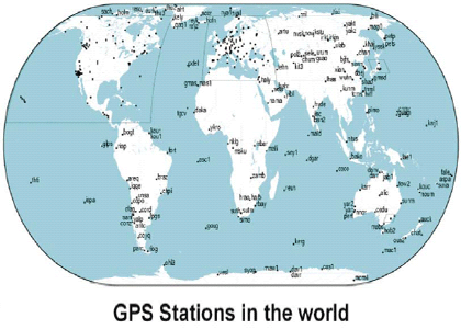
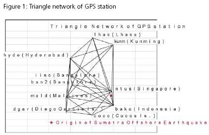
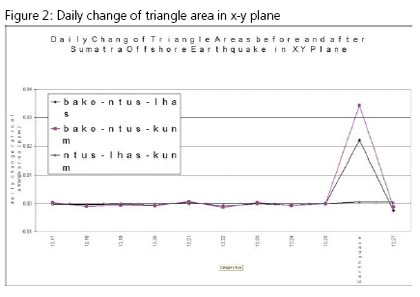
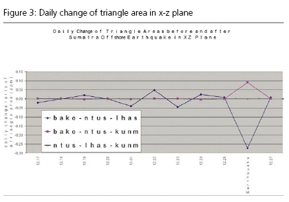
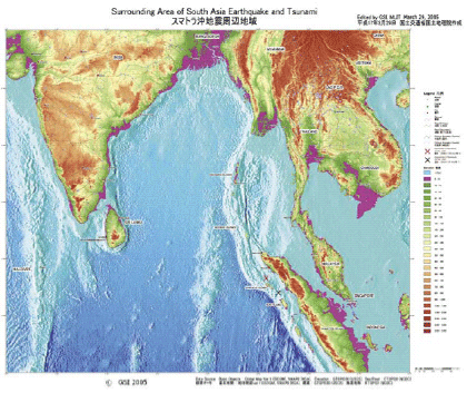
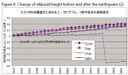
Since Japan is an earthquake prone country with a lot of volcanoes and active faults, Geographic Survey Institute (GSI), the Government of Japan has constructed about 1,200 GPS Fixed Stations called “electronic control points” all over Japan. Since 2003, GSI released GPS data to public through web site. The authors have already checked and confirmed the evidence of early warning for the past big earthquakes such as Tokachi Earthquake (M8.0: 2003.9.26) and Nigata Chu-etsu Earthquake (M6.8: 2004.10.23) which occurred in Hokkaido, north of Japan and middle of Japan respectively. International GPS Service (IGS) provides world wide GPS data at GPS stations located at 10 stations near Indonesia and other Asian regions. The past prediction of earthquake had been based on statistical analysis with the past earthquake records or a sort of estimation fromadditional records. Most of seismic scientists have not relied on GPS data because the accuracy of GPS data used to be intolerable and also the actual earthquake happened in several ten kilometers depth though GPS stations are located just on the surface of the earth. However there are some geodesists who tried to use GPS data for planimetric movement of the surface of the earth. In most cases, elevation data are not used due to the low accuracy. The movement analysis has been based on the assumption that a point is estimated as a non-move or fixed point. This analysis has two weak points. One is that the analysis is not three dimensional though there may be a type of earthquakes which will move not in the surface plane. The second problem will be the assumption to keep a point as fixed, though any point may have possibility of movement. In consideration of the past methods, the authors have developed a new early warning system for big earthquakes with more than M6.0 using daily GPS data in geocentric coordinate system. Indicators for early warningThe authors have proposed the following indicators or factors. • Coordinate System The geocentric coordinate system with the origin as the center of gravity of the earth, X axis as Greenwich Meridian on the surface of the equator, Y axis as 90 degree East longitude Meridian on the surface of the equator and Z axis as the rotational axis of the earth (ITRF2000 based on GRS-80). We considered that the center of gravity is the most reliable fixed point of the earth. • Triangle Networks The triangle networks should be considered all possible combination of triangles because the possibility of earthquake directions will not be able to be estimated. In this regard, the triangle networks are different from the geodetic triangle networks and triangulated irregular networks (TIN). A triangle with very narrow angle will be allowed. • Daily change ratio of a triangle area Because of the fluctuation of GPS data of geo-centric coordinates, we thought relative change of a triangle area will be more stable than the movement of point movement. In addition, we can predict a rough location of the origin of earthquake from the maximum value of the change ratio. The daily change ratio of triangle area can be calculated from the following formula. Daily Change Ratio of Triangle Area= (Area of the day – Area of the previous day)/ Area of the previous day • Triangle Area Triangle area is computed for the projection plane of XY, XZ and YZ, which enables three dimensional analyses though map oriented understanding would be a little hard. The reason why the triangle area change is used instead of the movement of coordinates because the sensitivity for the change ratio of triangle area is much higher and also we can estimate the location where earthquake may occur. • Threshold The maximum change ratio of triangle area in XY, XZ or YZ plane should be checked. Normally the unit of the change ratio is represented as ppm (one millionth) depending on the size of the triangle area. In case of Sumatra Earthquake, the triangle network has several hundreds and thousands kilometers distance between GPS stations. It gives the unit of 0.01 ppm in the daily change ratio of triangle area. The • Sudden change of sign The maximum change ratio will fluctuate from plus to minus or vice versa in a plane which showed the maximum ratio. Evidence of early warning for Sumatra offshore earthquakeThe authors selected the following ten GPS stations Figure 1 shows location of those GPS stations from IGS home page. We checked many cases of triangle combinations in which we found those triangles with bako, ntus, lhas and kunm showed evidence for early warning as shown in Figure 2, 3 and 4 with respect to the daily change ratio from December 17th to 27th, 2004 for XY, XZ and YZ projection plane respectively. There was a drastic daily change of -1.2 ppm in YZ plane in the triangle of ntuslhas- kunm on the 18th December 2004, 8 days before the earthquake. There was also big change of – 0.04, 0.05 and -0.05 ppm in XZ plane in the triangle of bako-ntuslhas on the 21st, 22nd and 23rd respectively December 2004, 3 to 5 days before the earthquake. In XY plane we don’t see very critical movement till the earthquake. On the day of the earthquake, the change ratio of the three triangles; bako-ntus-lhas, bako-ntus-kunm and ntus-lhas-kunm was drastic with the change ratio of -0.27 ppm in XZ plane, 0.09 ppm in XZ plane and 0.14 ppm in YZ plane respectively. It should be noted that the two tringles of bako-ntuslhas and bako-ntus-kunm showed the reverse change in XZ plane with the change ratio of -0.27 and +0.09 respectively. If we check the direction of the big fault between Indian and Eurasian Plate along the Island of Sumatra as shown in Figure 5, the direction of bako-ntus-lhas is almost the same with the direction of the boundary of the two Plates. Change of ellipsoidal height before and after the earthquakeThe authors also checked the change of the ellipsoidal height for the ten GPS stations. Figure 6 and 7 shows the height change with the datum as of the 2nd December 2004. It will be interesting to find that ntus in Singapore and iisc in Bangalore, India showed downs and ups respectively though other points except mald in Maldives showed a trend of ups gradually. Conclusions• It was easy to have detected Sumatra Offshore Earthquake itself from GPS daily data. • The evidence of early warning was found in the daily change ratio of the triangle area of ntus-lhas-kunm (Singapore-Lhasa-Kunming) in YZ plane on the 18th December 2004, 8 days before the earthquake, and bako-ntus-lhas (Indonesia- Singapore-Lhasa) in XZ plane on the 21st to 23rd December 2004, 3 to 5 days before the earthquake. • On the day of the earthquake, the three triangles of ntuslhas- kunm, bako-ntus-lhas and bako-ntus-kunm showed very drastic change. The two triangles of bako-ntus-lhas and bakontus- kunm showed the reverse movements along the boundary of the Indian and Eurasian Plate. ReferenceARAKI, Harumi and MURAI, Shunji (2005), Area Change of Triangle Networks for Prediction of Sumatra Offshore and Nigata Chu-etsu Earthquakes (Japanese), Proceedings of Annual Convention of Japan Society of Photogrammetry and Remote Sensing, June 23/24 2005 (pp 239-242) GSI (Geographic Survey Institute) Web Site: MURAI, Shunji and ARAKI, Harumi (2003), Earthquake Prediction Using GPS, GIM, Volume 17, No. 10, October 2003 MURAI, Shunji and ARAKI, Harumi (2004), Prediction of Earth quake and Volcanic Eruption using GPS, Asian Journal of Geoinformatics, Vol. 4, No. 3, March 2004 SOPAC Web Site: http://sopac. |
||||||||||||||||||||
|
||||||||||||||||||||
|



 (2 votes, average: 3.00 out of 5)


