Articles tagged with: PROF MADHAV N KULKARNI

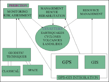
The 26th July 2005 floods in Mumbai, which caused widespread destruction, deaths and damage to property and infrastructure, have once again highlighted the importance of disaster mitigation and management using modern technology. Monitoring natural disasters like floods, earthquakes, volcanic eruptions, landslides, avalanches, cyclones, etc., with the ultimate aim of predicting them, and managing the rescue and rehabilitation operations during and after such calamities, have been discussed in various forums in the past. The devastating Latur earthquake of 1993, the Bhuj earthquake of 2001, the Orissa cyclone, and the recent tsunami after the Sumatra earthquake, which caused extensive damage in terms of human lives and property, have drawn the attention of the Indian scientific community to the immediate need of monitoring and managing such disasters in our country in the most effective, efficient and economic manner. Traditionally, maps are being used for this purpose, as an effective tool, since ancient times. However, with the introduction of computeraided techniques in map-making, and the space technology in surveying and mapping, the utility of geodetic and map data for this important activity has increased many-fold. However, a well-coordinated programme for optimum utilization of these important technological tools, resulting in efficient management of the disasters, still remains an elusive dream of administrators, scientists and technologists.


 (5.00 out of 5)