| Applications | |
Systematic Land Titling using Open Source Geospatial Software and Machine Learning: the MLG experience
In this paper, the use of open source software technologies are discussed including: geospatial software (e.g., GDAL, QGIS, Geoserver, PostGIS, Open Layers) to gather, store, manage, analyze and visualize geospatial data, machine learning to extract building footprints from drone imagery |
 |
|
 |
|
 |
|
 |
|
 |
|
 |
|
 |
|
 |
|
Medici Land Governance (MLG) captures property information including spatial and textual data by identifying and mapping land boundaries using high resolution drone imagery. MLG works closely with country governments to establish formal property ownership for land owners by implementing Systematic Land Titling programs using user-friendly, low-cost, and secure land administration systems built on open source geospatial technology. In this paper, the use of open source software technologies are discussed including: geospatial software (e.g., GDAL, QGIS, Geoserver, PostGIS, Open Layers) to gather, store, manage, analyze and visualize geospatial data, machine learning to extract building footprints from drone imagery and recognizing text from ID, and blockchain technology for tamper proof public records.
Introduction
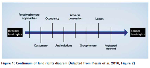
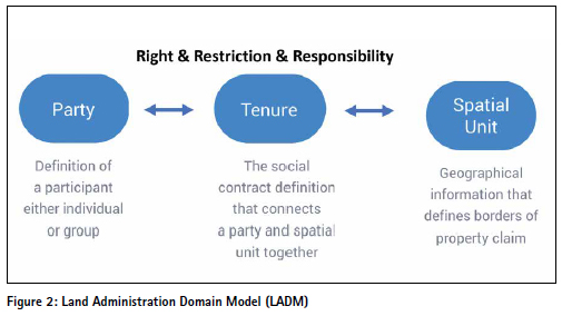
Lack of formal property rights is a significant issue in the world. Around 20%-30% of land parcels worldwide have been formally registered, resulting in land insecurity for many (White and Martin 2002). Traditional land administration systems for recording property rights can be expensive, restrictive in terms of technology, less efficient, and less transparent to government officials and land owners (Williamson et al. 2010). In this paper, it is demonstrated that new emerging technologies, open source software and availability of modern instruments would speed up mass titling in developing nations. The case of Lusaka, Zambia will be used as an example of the tools, applications and methodology developed by Medici Land Governance (MLG)1. In Systematic Land Titling (SLT), the right of ownership to surveyed land that is systematically gathered creates a relationship for the land owner (person), parcel and their individual right (Enemark et al. 2012). Rights of ownership follow the continuum of land rights from informal land rights to formal land rights (Plessis et al. 2016) (Figure 1). The fit-for-purpose SLT approach has been proposed as a solution for countries to secure land rights and guarantee formal land rights to land owners. A Land Administration Domain Model (LADM) encompassing the principals of party, spatial unit, and tenure has been developed for use by national and local governments. Free and open source software (FOSS) geospatial technologies are employed for gathering, storing, editing, managing, and visualizing geospatial data. Also, machine learning techniques are used to extract features from drone imagery and validate ID cards of land owners.
Land surveying has been a conventional approach for decades which has traditionally been seen as costly to land owners. Only a small percentage of land owners who are able to afford paying for the land surveying costs are able to benefit from this approach. However, a majority of the population is excluded from surveying which creates issues for land owners obtaining their certificate of title. The principles of general boundaries and digitizing parcel boundaries from high resolution images (e.g., drones) can be used as a cost-efficient, reliable, scalable, and a flexible approach to serve the purpose of the land surveying. Mass registration of property rights in a short time frame is possible using this approach, which has been recommended by the World Bank, and the International Federation of Surveyors (FIG) (Enemark et al. 2014). This has been demonstrated in Rwanda with the demarcation of 11.4 million parcels and issuance of 8.6 million titles in a period of five years (Sagashya, 2012; Nkurunziza 2015). The same happened in Ethiopia with 14 million of parcels of land went through the second level certification since 2013 (Di Falco, 2020). The use of real-time cloud-based field data collection in lieu of the traditional analogue collection of ownership information has a tremendous time and saving cost benefit. It can be argued that this technology saves time and cost on the process of demarcation of parcels, creation of cadastral maps and assembling information on title eligible parcels of land. Case studies comparing analogue titling used in Rwanda versus introducing field data collector in Zambia by MLG can support the case of using open source technologies to speed up the processes and to reduce the cost of SLT.
MLG in collaboration with the Zambian Ministry of Lands and Natural Resources (MLNR) successfully gathered titleready data for more than 45,000 landowners using streamlined processes and procedures for SLT. Following on the success of this project, MLG has started another phase for issuance of a least 250,000 Certificates of Titles, development of a Land Administration System, and storage of land records using blockchain technology to ensure land tenure security for property owners in Lusaka and promote social and economic development. To achieve this, three technology products have been designed to implement the project:
• Systematic Land Titling (Enum): Enum is a mobile platform developed to facilitate collection of evidence and documents in an automated workflow customized to reflect applicable streamlined regulations. This technology enables MLG to quickly and efficiently gather landowner information necessary for issuing land titles. Customizable forms, pictographic signature options (picture of signature), satellite and drone imagery capabilities as well as data recognition/validation technologies provide for powerful proof of ownership for efficient titling that integrates into land administration systems. It also provides for demarcation of land parcels, viewing of complete maps of parcel boundaries for review by members of the community and governing agencies before final, approved titles are issued.
• Land Administration System (Landum): MLG’s Land Information Management System (Landum), uses resilient technologies to provide a web portal dashboard and customized web map solutions for visualizing high resolution drone imagery and parcel data and digitally record, store and execute land transactions efficiently and cost-effectively. Landum is built using many opensource standards and infrastructure elements which provide security, efficiency and low-cost maintenance.
• Data Storage on Blockchain (Actum): MLG uses blockchain technology to provide a tamper-proof, immutable record of title that is searchable, transparent, trusted and secure.
A few notable comparisons support the case of using open source technologies for GIS to speed up mass titling, registration and reduce the cost per title. Open source software has a free license that guarantees all users access to the source code. It is designed and developed by the community of developers from all over the world. On the other hand, proprietary software has been developed by a team of developers from a single company. Choosing the appropriate system between open source or proprietary software can be challenging. proprietary solutions are widely used in land administration and cadastre systems, but the use of open source geospatial software has been significantly increased in the recent years (Zein et al. 2015). In this paper, open source GIS software technologies used to meet the objective of low-cost, time saving and efficiency are discussed.
Land Administration Domain Model (LADM) and Open Geospatial Standards
LADM developed by ISO / TC 211 Geographic Information / Geomatics is a international standard data model describing the basic component of land administration and the land administration data; i.e., the relationship between People and Land (Lemmen et al. 2019). Three main packages are defined in this formal mechanism; party (people and organizations), tenure (right, restriction, and responsibilities of the party), and spatial unit (parcels). This model as an international standard facilitates the development software applications and land administration systems (Lemmen and Oosterom, 2013; Van Oosterom, Lemmen, and Uitermark 2013). Also, land data aggregation from different sources can be easily managed using LADM (Lemmen, Van Oosterom, and Bennett 2015).
MLG is a member of FOSS4G (Free and Open Source Software for Geospatial), OSGEO (The Open Source Geospatial Foundation), and OGC (Open Geospatial Consortium) organizations. These are international organizations working on developing open specifications and standards for spatial data, spatial data sharing and interoperability. These organizations also are promoting the use and development of open source geospatial software (Marco et al. 2020). OGC also has a Land Administration Domain Working Group that uses OGC open standards or defines new standards to improve the effectiveness of Land Administration Systems (Lemmen et al. 2019). Here are some of the OGC web services standard for storing, visualizing and processing of vector and raster data on the web:
• Web Map Service (WMS): WMS defines standards for requesting map images over the Internet. Images can be transferred as a web service by changing parameters such as size and coordinate reference systems.
• Web Feature Service (WFS): WFS is a web service used for publishing and querying of vector data (point, line, polygons or other geometries) on the web.
• Web Map Tile Service (WMTS): map tile service (WMTS) is used to optimize performance of the WMS by tiling of images and prerendering georeferenced map tiles.
• Web Coverage Service (WCS): this service returns raster data with their detailed descriptions and is used for sharing raster data on the web. WMS only returns a static image with its original semantics.
Drone Mapping and Machine Learning
MLG uses real-time kinematic enabled drones to capture high-resolution upto- date imagery to decrease time, cost, and complexity of conventional land surveying. Drone imagery is used to extract a variety of spatial information such as parcel boundaries, building footprints, building elevations, roads, waterbodies, etc. MLG also employs machine learning to automate feature extraction and various elements of property mapping in order to significantly increase the scale and speed of boundary demarcation for property rights delivery. Furthermore, MLG uses drones, machine learning, and geospatial techniques to help estimate property values which promotes equity in valuation and taxation and allows for a cost effective and more frequent valuation updating.
An open source photogrammetry toolkit named OpenDroneMap2 is tested to process drone imageries and to generate orthophotos, DEMs and 3D models. The results are compared with Pix4D3, a proprietary software which is widely used for processing drone imagery. The generated raster data is clipped and projected using GDAL as an open source geospatial module. Based on our experience, for a large-scale project with a very large dataset, this simple operations takes a long time using other conventional GIS software.
The high-resolution imagery as a very valuable data source is processed using machine learning algorithms to automatically extract different type of spatial data. FastAI4 is an open source python module used to extract building footprints from drone imagery. Pre-existing building footprints are downloaded from Open Street Map (OSM)5 and are used for training the deep learning model. Osmium6 and Robosat7 are used to process the OSM data and extract buildings as a GeoJson file. GDAL8 is used to make titles and generate a Slippy map as well as to convert OSM GeoJson files to binary Geotifs. Finally, FastAI is used to train a segmentation model to be used for extracting building footprints in other areas.
Spatial Data Infrastructure
A large amount of data is captured with drones and various type of geospatial data can be extracted from the imagery. A Spatial Data Infrastructure (SDI) is needed to manage the data, metadata and users, simplify the search and discovery of geospatial data, and maintain data integrity. Based on another definition, SDI is “the technology, policies, standards, human resources, and related activities necessary to acquire, process, distribute, use, maintain, and preserve spatial data” (The White House, Office of Management and Budget 2002). MLG is testing GeoNode9 as an open source geospatial content management system for deploying a SDI. The goal is to provide a geospatial data portal that all of the organizations and stakeholders can have an easy access to the data. For example, the drone imagery captured for a large area and other data extracted from imagery (e.g., parcels, building footprints, roads, rivers) needs to be imported into a spatial data structure in order to be easily accessible for visualization and download by various organizations.
Desktop GIS and Geospatial Libraries
QGIS10 as an open source cross-platform and free desktop geospatial software is used to manage and analyze the vector and raster data stored in Open Geospatial Consortium (OGC) formats such as GeoPackage and GeoJSON. QGIS is actively developed by a very large community of contributors and improvements and new features are frequently added to the software. It is flexible and new tools can be developed to meet the exact specifications without dependending on external party. It has a much lower total cost of ownership. It provides a culture of collaboration and can attract better talents for the company and some other advantages such as greater security, more freedom and customization, and working on most operating systems. It has some disadvantages as well such as the lack of some tools for analysis and modeling and the lack of a good technical support (Badea and Badea 2016).
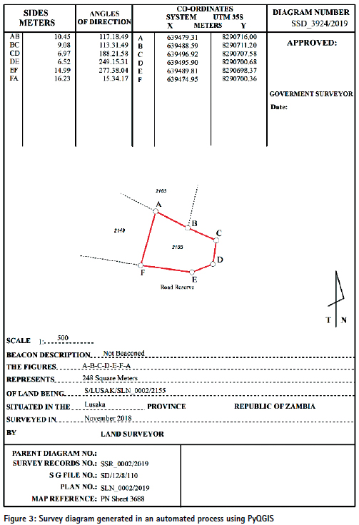
Python and some open source geospatial modules (e.g., GDAL, Rasterio11, Geopandas12, Shapely13) are used to process drone images and automate GIS processes. For example, Geopandas is used to read and write parcel data, and check for attribute and geometry issues. PyQGIS is used as an stand-alone python script for automated generation of survey diagrams while producing land titles. Figure 3 shows the survey diagram generated using PyQGIS. It only takes 3 seconds to generate each diagram that is quite fast. The other advantage of PyQGIS is the possibility if running the code in a QGIS docker. This way the entire process for generating these diagrams can be automated on the cloud.
GDAL/OGR are used as the core geospatial libraries for geospatial ETL processes. GDAL is used for reading, writing, and processing of raster data and OGR is used for handling simple features vector data. Geographic Resources Analysis Support System (GRASS) is also used for cleaning the geometry for solving topological errors.
GIS Web Mapping
Geospatial vector data is transformed to a database implemented on the cloud to be used in mobile and web land titling applications. PostgreSQL14 as an open source relational object-based database is used to store and analyze spatial data. PostGIS15 as an extension of PostgreSQL is used to provide simple and advanced spatial analytic capability and is natively supported by other GIS applications and libraries such as Geoserver, QGIS, and GDAL. Geospatial raster data is stored on the Geoserver16 that is an open source server used for sharing and mapping imagery and parcel data using standard protocols developed by the OGC such as Web Map Service (WMS), and Web Feature Service (WFS). For designing web-based mapping applications, Open Layer17 is used as an open-source JavaScript library. Open Street Map is used as a base layer for web mapping solution.
A cloud-based system is used to host the geospatial software and to maintain the ownership and geospatial data. Everything is packaged in a docker and so can be easily implemented in different environments to provide a cost-efficient land administration software solution. None of the software discussed here require a license and as a result the web mapping solution used in the land administration system can be easily implemented in different places without any licensing cost.
GIS Mobile Mapping
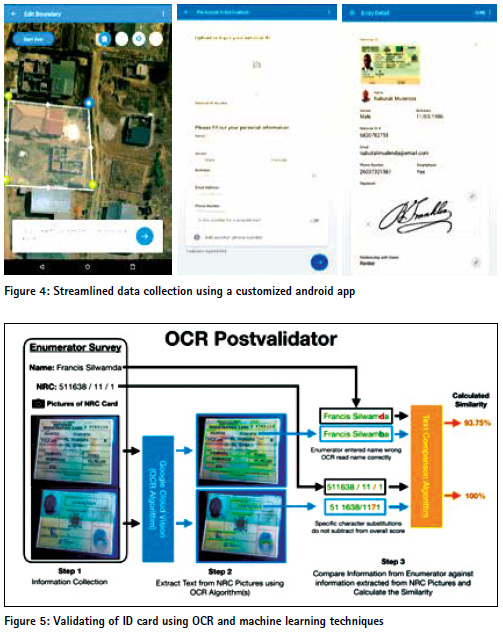
MLG has developed an android mobile application (a data collector app called Enum), used for data collection of land ownership information as a cost-effective, time-efficient, transparent, and scalable approach. Enum is installed on a tablet that allows on-the-ground enumerators to move from area and homes gathering spatial and textual information. It is unique in its features and capabilities and has been engineered to manipulate, change and create parcel boundaries to reflect the “reality” on the ground using a high resolution imagery. As mentioned, Enum collects land owner information (national ID cards, signatures, photos of the property, etc.), in addition to spatial data. The application automatically synchronizes and sends collected data to a server installed on the cloud. The application has a web application that generates reports of work done by enumerators in the field. Comparing the use of Enum to the traditional analogue collection of ownership information and use of printed maps and demarcation using pencil and pen and then digitization; it can be argued that this technology saves time and cost on the process of demarcation of parcels, creation of cadastral maps and assembling information on title eligible parcels of land. Case studies comparing analogue systematic titling used in Rwanda versus introducing our data collector app in Zambia by MLG can support the case of using open source technologies to speed the time and cost of SLT. Enum can be easily customized to meet the requirements of different land regulations and types of tenure in different countries. There is no need for purchasing and renewing any license and so it can be used in different projects with relatively no additional without cost. Figure 4 illustrates the android app interface used by enumerators to travel to properties to complete applications and to collect signatures and photographs for official documentation and titling.
MLG uses an advanced Optical Character Recognition (OCR) algorithm to validate collected data to the photo of the identity card provided by the land owner. The collected survey data is compared against the OCR extracted information to calculate an overall similarity between the survey and the identity card (Figure 5). Using this process, MLG is able to quickly validate collected information for accuracy, eliminating the timeconsuming manual verification processes. Currently this validation is done offline after capturing the data. In the future, this unique process is going to be implemented in Enum to have a realtime validation of ID cards on the field.
Blockchain Land Registry
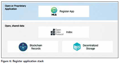
MLG is becoming a leader in the use of blockchain for land administration. Blockchain bolsters reliability and authenticity of land records (Larson and Chrysostom 2019). Blockchain can produce a number of benefits for a wide array of applications that (a) require data immutability, (b) require transparent modification history (c) require unique digital representation of assets (such as property, votes, securities, or identities) and (d) two or more entities that want a single, shared view of information about those assets. MLG is using multiple open source blockchain technologies to secure titles and build next-generation land administration systems for both the developing world and developed countries. MLG archives its land record data into the FLO18 Blockchain by using the Open Index Protocol (OIP)19. OIP is an open source specification for an immutable, persistent, worldwide index and file library. OIP uses blockchain technology and distributed networking to operate with no central authority. OIP’s record indexing, file storage/ distribution and transaction management are all carried out collectively by the decentralized network. OIP additionally utilizes the Inter-Planetary File System (IPFS)20 in order to provide tamperproof file storage/distribution that is atrophy resistant. Figure 6 illustrates an abstract of the MLG blockchain register app. MLG has documented and shared the code for this register app called Actum at https://github.com/mediciland.
Summary
In two years of MLG’s presence in Zambia, the teams have explored, learned and tested the use of free open source software for SLT to build robust land administration systems. Using the above-mentioned technologies, during the Ministry of Lands and Natural Resources (MLNR) pilot project in Lusaka, Zambia, MLG collected about 45,000 land parcels’ information which led to title eligible parcels in less than one year. Historically, the MLNR in Zambia has titled up to 13,000 land parcels in a year with the sporadic land titling processes.
The successful completion of the pilot phase has led to an agreement between Lusaka City Council and MLG for the issuance of no less than 250,000 certificates of title to land owners. The use of open source technology has helped MLG to provide a low cost, efficient and scalable solution. Open source software has tremendous benefits and has gained enormous popularity in the recent years. It can encourage innovation, increase the number of users and provide new solutions to old problems. MLG has used open source to provide customized tools and applications without boundaries or limitations.
Endnotes
1 https://www.mediciland.com
2 https://www. opendronemap.org
3 https://www.pix4d.com/
4 https://www.fast.ai
5 https://www.openstreetmap.org
6 https://github.com/ osmcode/osmium-tool
7 https://github.com/mapbox/robosat
8 https://www.gdal.org
9 http://geonode.org
10 https://www.qgis.org
11 https://rasterio.readthedocs. io/en/stable/
12 http://geopandas.org/
13 https://github.com/ Toblerity/Shapely
14 https://www.postgresql.org
15 https://postgis.net/
16 http://geoserver.org/
17 https://openlayers.org/
18 https://flo.cash/
19 https://www. openindexprotocol.com
20 https://ipfs.io
References
Badea, A. C., & Badea, G. (2016). Considerations on Open Source GIS Software vs. Proprietary GIS Software. RevCAD 20.
Di Falco, S., Laurent-Lucchetti, J., Veronesi, M., & Kohlin, G. (2020). Property Rights, Land Disputes and Water Scarcity: Empirical Evidence from Ethiopia. American Journal of Agricultural Economics, 102(1), 54-71.
Du Plessis, J., Augustinus, C., Barry, M., Lemmen, C., & Royson, L. (2016, March). The continuum of land rights approach to tenure security: consolidating advances in theory and practice+ powerpoint. In Scaling up responsible land governance, proceedings of the annual World Bank conference on land and poverty, 14-18 March 2016, Washington DC, United States (pp. 1-48).
Enemark, S., Bell, K. C., Lemmen, C. H. J., & McLaren, R. (2014). Fit-forpurpose land administration. International Federation of Surveyors (FIG).
Enemark, S., McLaren, R., & Lemmen, C. (2015). Fit-for-purpose land administration guiding principles. Global Land Tool Network (GLTN): Copenhagen, Denmark.
Larson, T., Chrysostom, C. (2019). Deploying titling and customary land registration systems with a blockchain element. The annual World Bank conference on land and poverty, 25-29 March 2019, Washington DC, United States. Lemmen, C. H. J., & Van Oosterom, P. J. M. (2013). The land administration domain model standard. In Proceedings 5th Land Administration Domain Model Workshop, Kuala Lumpur, Malaysia, 24-25 September 2013. FIG.
Lemmen, C., Van Oosterom, P., & Bennett, R. (2015). The land administration domain model. Land use policy, 49, 535-545.
Lemmen, C. H. J., van Oosterom, P. J. M., Kalantari, M., Unger, E. M., & De Zeeuw, C. J. (2019). OGC White Paper on Land Administration. Marco, M., Amin, M., Rautenbach, V., & Brovelli, M. A. (2020). Geospatial openness: from software to standards & data. Open Geospatial Data, Software and Standards, 5(1).
Nkurunziza E. (2015). Implementing and sustaining land tenure regularization in Rwanda. In: Hilhorst T. & Meunier F. ed., How innovation in land administration reform improve on doing business. Washington DC: World Bank, pp. 10-19
Sagashya, D. G. (2012). Rwanda: Reforming land administration to enhance the investment environment. Untying the Land Knot: Making Equitable, Efficient, and Sustainable Use of Industrial and Commercial Land, Washington: World Bank Publications, 57-70.
The White House, Office of Management and Budget (2002) Circular No. A-16 Revised, August 19, 2002
Van Oosterom, P., Lemmen, C., & Uitermark, H. (2013). ISO 19152: 2012, land administration domain model published by ISO. FIG Working Week 2013 in Nigeria– Environment for Sustainability, Abuja, Nigeria, 6–10 May 2013.
White, A., & Martin, A. (2002). Who owns the world’s forests. Forest Trends, Washington, DC.
Williamson, I., Enemark, S., Wallace, J., & Rajabifard, A. (2010). Land administration for sustainable development (p. 487). Redlands, CA: ESRI Press Academic.
ZEIN, T., TIMM, C., & HARTFIEL, D. P. (2015). Concept, Design and Development of Land Administration and Cadastre Systems Using Open Source Software. In 2015 World Bank Conference on Land and Poverty (pp. 23-27).
The Paper Prepared For Presentation At The “2020 World Bank Conference on Land and Poverty” The World Bank – Washington DC, March 16-20, 2020.


 (1 votes, average: 1.00 out of 5)


Leave your response!