| Applications | |
Systematic land registration in Georgia – Design and implementation
The paper analyzes the implementation process, provides an overview of the preexisting problems and discusses the means on how the Pilot Project has addressed the shortcomings |
 |
|
 |
|
Abstract
The paper seeks to provide overview of the Pilot Project on Systematic Land Registration which was implemented in Georgia by the National Agency of Public Registry of Georgia through the funding allocated by the World Bank (IDA). The paper analyzes the implementation process, provides an overview of the pre-existing problems and discusses the means Pilot Project has addressed the shortcomings.
It also provides the overview of findings and recommendations set forth by the project to the Georgian Government based on the project baseline data.
Circumstances leading to implementation
Following the breakup of the Soviet Union, Georgia embarked on the mission to transform itself into a market based economy, which most importantly started with the implementation of the Land Reform. The 1992 land privatization program, which was mainly complete by 1998, transferred 60 percent of the arable land and perennials to about one million Georgian households. However due to the complications in the distribution of the land, as well as ensuing chaos that followed the internal conflicts, resulted into registration of only 20% of the agricultural land plots.
The registration began in 1999, with assistance from USAID, KfW, UNDP, GTZ and WB. The projects encompassing almost the entire territory of Georgia carried out land survey and registration activities using different technologies and procedures. That resulted in collection of heterogeneous cadastral and registration information. The reason was in part the inadequate coordination of donor activities by the donors and by relevant state agencies. One impeding circumstance was the duplication of functions of the State Department for Land Management recording information about land and the Bureau of Technical Inventory recording information building construction. In 2004, SLDM and BTI were succeeded by the National Agency for Property Registration, which is highly efficient by international standards. The land privatization and evolving requirements for registration however, resulted in a situation whereby the majority of land ownership rights are not registered in NAPR. The MOA estimates that between 15-20% of agricultural land plots are registered. The main reason for the low registration coverage is the diverse range of methods and poorly coordinated projects through which land ownership rights were issued during privatization.
This in combination with other factors, served as a catalyst for the Georgian government to initiate a land reform in 2016 which aimed and increased number of registered land plots by subsidizing the land measurement procedures and cutting the red tapes hindering the registration process. This was made possible due to enactment by the Parliament of Georgia, on June 3, 2016, of the groundbreaking Law on Special Procedures for Systematic and Sporadic Registration of Land Plots and Improvement of Cadastral Data under State Project. From the beginning, the reform laid ground for two separate directions, free sporadic registration, based on the applications of the interested parties and the pilot project on systematic land registration. While the sporadic registration of the land reform was a major breakthrough for the government as it resulted in 700 000 successful registration applications, it will not be subject of the present paper. We will focus on the Pilot Project on Systematic Land Registration and its results.
Design of the Pilot
Georgia and International Development Association signed in 2014 a $50 million loan agreement for improvement of delivery of irrigation and drainage services in selected areas and development of improved policies and procedures as a basis for a national program of land registration. The resulting Irrigation and Land Market Development Project (ILMDP) consists of three components: Component 1 – Irrigation and Drainage Improvement implemented by the Ministry of Agriculture of Georgia ($45.65 million), Component 2 – Land Market Development implemented by the Ministry of Justice through the National Agency for Public Registry ($2.25 million) and Component 3 – Project Management ($2.10 million). The Project became effective in March 13, 2015 with a closing date on July 31 2021.
Under Component 2, ILMDP financed the pilot phase of a land registration program designed to redefine and test the policies and procedures for registration of agricultural land that would allow the majority of existing land ownership rights to be registered. The pilot included three key elements:
• Policy and Procedural Development, including government’s guidelines for land registration by the project, that would develop the methodology for land registration, define policies, procedures and dispute resolution mechanisms for different land possession scenarios to be dealt with under the pilot, and improving the guidelines based on lessons from the pilot as a basis for a national program.
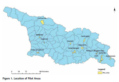
• Pilot Project of about 48,000 parcels in 11 pilot areas consisting of 12 settlements across Georgia (Figure 1) selected to represent the geographic variety and land tenure situations in the country. Piloting involved training of staff and surveyors, social mobilization of landowners, collection of land title document, surveying of land plots, updating maps and registration documents, dispute resolution, registration and issue of electronic certificates.
• Development of a Land Registration Monitoring System, to assess the effectiveness of policies and procedures for pilot land registration including the quantitative impact of land registration (on land transactions, land disputes, investment in land, farm productivity and profitability) and progress in implementation of nationwide land registration in future.
The implementing agency of the project is Ministry of Justice of Georgia (MoJ) through the National Agency of Public Registry of Georgia (NAPR), a legal entity of public law under the MOJ.
Implementation of the Pilot
NAPR launched the pilot project on land systematic registration in two phases in 2017. Phase I of the project concentrated on i) Development of the Guidelines on Systematic Land registration (Guidelines) through involvement of the international consultant ii) Hiring and of staff and creating the Pilot Project Core Team and iii) Carrying out systematic land registration in Manglisi Pilot Area by using newly adopted Guidelines. After the completion of the Phase I, NAPR would launch the systematic registration in remaining pilot areas thus beginning the Phase II of the project.
The pilot was aimed at resolving the data inconsistencies caused by missing or incorrect cadastral information and unspecified cadastral data, and provide NAPR with information in order to: 1) ascertain compliance of the cadastral data with the actual location of the land plots; 2) ensure compliance of the unspecified land plot cadastral data registered in the public registry with the requirements of the laws in Georgia; 3) ensure compliance of the specified land plot cadastral data registered in the public registry with the actual location of the land plots and make relevant correction in line with the procedures prescribed by the laws in Georgia.
The implementation process for systematic registration was conducted in six phases: 1) Preparation activities; 2) Public awareness 3) Technical fieldwork 4) Public display 5) Verification of survey results 6) Registration.
The registration was based on the Law on Systematic and Sporadic Registration of 2016 and included full cadastral survey and creation of a database of all privately owned land, land owned by the GOG, and land owned by the municipalities.
Phase I
Guidelines on Systematic Land Registration were sent to the World Bank for review on March 1, 2017 and based on comments from the Bank which mainly aimed at increasing degree of the property rights protection, Guidelines were adopted following receiving the No Objection from the World Bank on May 15, 2017. Simultaneously, NAPR began the formation of the Project core team and procurement of the field and office equipment. With support of the of the German Society for International Cooperation (GIZ) under the EU-funded Project “Support to the Development of Private and Administrative Law System in Georgia” NAPR trained municipality representatives and members of Local Property Rights Recognition Commissions in the new procedures set out by the Law and the Guidelines. Additional funds were distributed to support the social mobilization campaigns in the Pilot Areas.
The initial idea behind the Guidelines was that the registration fieldwork should be done by private companies authorized through contracts with NAPR to perform cadastral survey and collect documents for registration in the public registry. The contractor was required to combine the registration documents into registration packages and uploading them to the NAPR electronic land registration system. After passing internal quality control, the packages were reviewed by Pilot Project Cores Staff (PPCT), which also performed field checks of the survey work. Based on the results, PPCT recommended approval or rejection. If rejected, the data was returned for correction. If accepted it was considered ready for registration. Then the survey data went to NAPR where the Geodesy and Geoinformation Department conducted final quality control (QC) and entered it into the cadastral database. On its end, the Property Registration Department performed QC on the registration documents collected by the contractor and made registrations in the public registry.
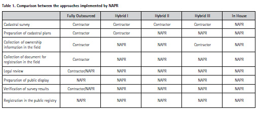
NAPR tested three different approaches during the registration process. The approach to the implementation of the pilot project has passed through several stages in search of the most effective technical and financial solution. Comparison between the approaches is presented in Table 1.
i. Fully Outsourced Approach
The first contract for systematic registration in the pilot areas was awarded for Manglisi Pilot Area. The work included surveying and preparation of cadastral plans, collection of data and documents necessary for registration in the public register, participation in public display, involvement in dispute resolution, correction of errors and gaps, participation in public awareness and information activities.
The contractor was required to perform the fieldwork for the entire pilot area based on an analysis of the existing title documents, ortho and mapping data, and according to the procedures established by law and the Guidelines.
The contractor implemented a flawed methodology without preliminary analysis of the available title documents. It deployed inadequately trained and insufficient personnel5 and inadequately supervised the project. Most human and technological resources were spent on the cadastral survey, while the legal analysis was paid little attention. The staff lacked familiarity with the Guidelines. The company had no internal quality control and quality assurance mechanisms.
As a result, NAPR received incomplete registration packages. Despite the regular communication, meetings and weekly reminders, the contractor failed to provide the registration data required by the contract. On November 3, 2017, three and a half months after signing, the contract was terminated. NAPR still made payments for the GPS points and cadastral drawings that were used in subsequent registration at the significantly reduced price.
Phase II
After the failure of the first contract for Manglisi, NAPR decided to test two alternative implementation approaches – hybrid and in-house.
Hybrid approach was designed to split the legal and technical part of the project between the NAPR and the contractor, surveys are conducted by the private company selected through a tender and legal side of the project is sorted by the NAPR team;. APR successfully tested this approach in first pilot area after which it was further refined and simplified, whereas the GIS works were transferred to the NAPR and the contractor conducted only the fieldworks. This approach was than successfully tested in other Pilot Areas.
In-House Approach was designed to conduct the systematic registration entirely with the in-house team, NAPR transformed to the sole responsible party for fieldworks as well as the legal aspect of the registration. This approach was introduced right after first unsuccessful attempt of the outsourcing the entire process to the private companies and it was also successfully tested.
i. Hybrid approach
Hybrid Approach divided the tasks between the NAPR and the private contractors. With the hybrid approach, the survey fieldwork was contracted to the survey companies, while the legal aspects of the systematic land registration were done entirely by NAPR. The contractor was required to perform boundary measurements under the close guidance of the NAPR Regional Facilitators who collected and analyzed registration documents provided by the interested parties. The contractor was also required to set up an office in the pilot area, participate in public awareness and information activities, Public Displays and dispute resolution process. It was also obliged to correct errors and perform verification of survey results.
Prior to entering the pilot area, NAPR would divide the area into registration blocks and their boundaries would be approved by the local municipality (This was the standard practice for all pilot areas). Contractor submitted survey data and registration packages NAPR on a block-by-block basis. Each delivery passed quality control. The registration documents were checked in accordance with the ISO 2859-1 Standard Sampling Procedures for Inspection. The boundary surveys were controlled by field checks of no less than ten percent of delivered data.
In order to ease off the fieldwork management, NAPR removed GIS work from the contractor obligations and began to outsource only the cadastral surveys. Contractor’s sole responsibility was to make measurements while all GIS and registration works were taken over by NAPR (Hybrid II). This simplification was expected to lower the costs, improve the quality and break the monopoly of several expensive companies, which dominated the survey market. Finally NAPR improved the Hybrid approach further by requesting the contractor to collect also ownership information and work closely with the RF (Hybrid III). The modifications in the Hybrid approach are presented in Table 1.
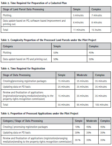
Hybrid I approach was implemented in Salkhino area. The contractor underwent trainings prior to beginning of the fieldwork. The initial quality control however, revealed discrepancies in the produced data and NAPR provided additional trainings related to TOR. The PPCT QC specialists spent 14 calendar days in the field to share their experience and provide practical advices. It was revealed that the preparation of cadastral plans poses the main problem because takes considerable time. Therefore, NAPR developed a computer application that considerably shortened it and enhanced the quality of the produced drawings.
Hybrid II approach was implemented in Zaridzeebi area. Based on the experience from Salkhino, NAPR removed cadastral plan preparation (GIS Works) from the contractor requirements. Contractor delivered all field measurements to the required quality and standard. The NAPR involvement in the survey work was considerably less in comparison with Hybrid I approach.
Hybrid III approach was implemented in Vedidkari area. In contrast with Hybrid I and Hybrid II, the contractor was requested to collect ownership information. The RF worked in parallel with the surveyors to collect the necessary documents. Afterwards the information was combined and processed submitted to NAPR for review. This approach almost eliminated the need of RF and decreased their related expenses incurred by NAPR.
The hybrid approach with its modifications proved that it is possible to outsource the fieldwork to private companies. To be effective, the contractors should be released from responsibility to analyze registration documents and prepare cadastral plans. One of the findings of the hybrid approach was the need to appoint a Contract Manager for each area to keep track of the contractor delivery dates, monitor its work plan and establish communication between the contractor and NAPR units.
ii. In-house Approach
With the in-house approach, all technical and legal fieldwork was carried out by the NAPR. This fully eliminated the need of contractors in the systematic registration process. In order to facilitate the application of the in-house approach, NAPR received a “No Objection” from the World Bank to: i) purchase additional equipment and contract an In-house team; and ii) incur project support costs for a technical staff to perform legal fieldwork and help survey teams.
The in house approach was implemented in 8 pilot areas including Jimiti, Mzisguli, Arboshiki, Arkhiloskalo, Saguramo, Lakhamula, Shuakhevi, Karaleti and partially Manglisi. In these areas NAPR utilized all available resources. With their specific knowledge in land registration, the in house teams performed well in extremely tight schedules. However the downside was the logistical strain on NAPR. The pilot areas were far and without facilities for long time accommodation. The teams had to return home periodically, which negatively affected the project costs.
Changes in workflow
During the Phase II of the project several major changes were introduced to the workflow, substantially changing the existing workflow under the guidelines.
According to the original process description, the field teams were required to deliver documents and data to NAPR on a weekly basis. The survey data was periodically controlled by the QC Team and then entered (after topology checks) into the cadastral database by the Geodesy and Geoinformation Department. On their side, the registration packages were reviewed by PPCT. After collecting all data for the pilot area, it was presented in a Public Display where the interested persons could perform control and make contests. If not contested, the data was considered approved and legally valid. In case of problems, interested persons might request verifications according to the procedures established by law. Finally, the registration data went to the Property Registration Department for final QC and recording into the public registry. In case of illegally occupied land, PRD submitted an application to LPRRC and performed registration after their decision.
According to the new implemented workflow, the field teams composed by surveyors and Regional Facilitators deliver survey and registration data after the completion of each registration block. Then the registration packages go to the Technical Support Staff, which performs an initial quality control to discover technical discrepancies before sending to Public Display. TSS checks the data against the records in other governmental databases and contacts interested persons to validate the information and make corrections. Once compliance is ensured, GGD integrates the survey data into the electronic cadastral database and together with TSS prepares survey plans and a plan of the registration block. Together with other documents and after passing QC by TSS and GGD, these plans are presented in Public Display and signed by the owners. After Public Display and if necessary after verification of the survey results, PRD performs registration according to the law. In case of illegally occupied land, PRD submits an application to LPRRC and performs registration after their decision.
The responsibilities of the Regional Facilitators were changed and the new position of a Local Regional Facilitator was created. The changes were aimed at improving the performance and facilitate implementation of the hybrid and in-house approaches. The original responsibilities of the Regional Facilitators were to assist the registration work on site and ensure good communication with local authorities and citizens. The RF still retain their previous functions to provide public awareness and information; organize events in the pilot areas together with PRU, introduce normative acts to the population; collect questions, comments and complaints; participate in Public Displays; keep connection with administrative units, city councils, NAPR and/or other administrative bodies; assist in dispute resolution. These functions were extended and the RF are now also responsible for coordination of the Public Display process, collection and keeping record of applications for verification of survey results.
The most significant change however, is that the RFs are now part of the field teams together with surveyors. While the surveyors perform boundary surveys in accordance with the predetermined schedule, the RF verify, collect and analyze registration documents provided by the owners. They are also responsible for the coordination of the field teams (except for the survey teams) and provision of technical assistance. Some previous responsibilities of the RF are transferred to the new created position of the Local Regional Facilitator. They are employed from the local population to know well the territory and land issues over it and work under the direction of the RF. Main responsibility of the LRF is to communicate with the population and representatives of the municipalities. They also collect information on interested parties during the cadastral surveys, participate in Public Display and resolve logistical issues related to the fieldwork.
NAPR introduced a new computer application designed to speed up the information exchange. It provides the RF with tools for collection of field data, which automatically is uploaded into the servers of NAPR. Once processed by the TSS, the data is uploaded back into the servers. The application also facilitates the communication between the Property Registration Department and GIS operators.
Other project related activities
Systematic land registration in the pilot areas produced interesting results in all aspects of land registration. Pilot project financed number of activities aimed at improving the land registration process as well as activities aimed at better understanding the overall problems faced by the project in the registration process.
i. Baseline research in the pilot areas
The Pilot Project conducted a baseline assessment in four pilot areas to: i) evaluate among others the importance of land registration to the local populations, ii) identify challenges faced by the households in the registration process and iii) provide a basis for better assessment of the project outcomes. The survey involved 800 households in Karaleti, Vedidkari, Zaridzeebi and Shuakhevi to obtain information on land ownership, land use, perceptions of tenure security, land transactions, types of land use, investments, sources of information in the areas, people’s trust in government agencies, the importance and outcomes of land registration reforms. The main results show that:
• 17% of households registered their land over the past five years. The reasons for not attempting to register vary according to settlements. In Zaridzeebi, it is the expensiveness of the procedure (40%). In Vedidkari and Shuakhevi 36% and 48%, do not deem registration necessary. In Karaleti 68% of the households, give as a main reason the prolonged procedure.
• The main reasons why the residents could not to register their land are the absence of documents, expensiveness and lack of knowledge on the procedure.
• Absolute majority of the households in all target areas do not expect to lose the right of ownership or use on residential or arable land parcel within the nearest 5 years, whether they have ownership documents completely in order or not.
• 38% of households recognize the right to sell or assign residential land parcels and 31% in case of arable land parcels. These numbers are significantly lower in Karaleti where the main document for ownership is the systematic registration card (so-called Shevardnadze document) but not a record from the Public Registry, which is the case in the other communities.
• Main sources of community-related information on municipal/district issues are the fellow villagers (77%) and local TV/radio (39%). This is not a comprehensive review of the baseline research, but a small demonstration. The outcomes of the Baseline research warrant a separate paper in itself.
ii. Web portal and software application for the systematic land registration
NAPR developed a computer application to automate and standardize the systematic registrations process. It allows for processing of field data, researching ownership data, archiving parcel related documents, cadastral survey plans and registration blocks in a completely automated way. This saves time and unifies the data format and storage in a single database. The application can produce hard copies of survey plans, layouts of changes and overlaps, plans of sets of parcels or registration blocks.
The new application improves the efficiency of the registrars and GIS managers. Prioir to adoption of the software, 2h and 50m was needed to process a block in a settlement while with the new application this is reduced to 1h and 10m. Similarly, the time to process an agricultural block was reduced from 2h 12m to 1h and 20m. The samples used for testing include 15 plots in residential (settlements) and 18 plots in agricultural land.
The major outcomes from using the application are reduced number of defects, unification of data storage, increased accountability and economy of time and resources.
The PP created a web portal to improve the provision of electronic services and provide comprehensive information on the registration process. It presents regularly updated information on the project status, results, findings and conducted public displays. The portal is a powerful tool for increasing public awareness and promoting the project and NAPR.
Main take aways
Main findings of the Pilot project will shape the national policy regarding the land systematic registration in Georgia. Based on the pilot findings government of Georgia introduced the legislative amendments to the Law on Systematic and Sporadic Registration which was adopted by the parliament and came into effect on January 01, 2020.
i. National registration strategy
A comprehensive land register with high quality and comprehensive data is a significant tool to support economic growth, innovation and the overall property market. It guarantees that the ownership of all land is transparent, plays a critical role in the property market and supports the government’s infrastructure objectives.
The results from the pilot areas indicate mass and significant differences between new and existing cadastral (map) data. This can be considered for the whole territory of Georgia. Therefore, systematic registration will provide the most efficient and effective solution. It will quickly provide the land register with more comprehensive information and more people with improved rights. Systematic registration is the most direct way to start using effectively the advanced registration system of the country. The priority should be given to systematic registration leaving sporadic registrations to be done on demand.
The government should identify priority areas for systematic registration and the process should occur region by region depending on the available funding and technical resources. The initial focus should be on areas with property market activities or infrastructure projects to maximize the early impact. Areas with more than 85 % of registration coverage should have lower priority in the nationwide systematic registration campaign. Meanwhile property should be registered by sporadic registration under an improved procedure to ensure data integrity. Most advantageous system for a national rollout is the hybrid approach where the survey fieldwork is outsourced while the legal part is entirely done by NAPR. This will release NAPR from fieldwork to concentrate on strengthening and improving the QC processes. To exploit the full potential of the hybrid approach, NAPR should reintroduce the certification of surveyors and surveying companies. The implementation capacity can be further scaled up by a wider involvement of the private sector to collect and investigate registration documents in the field.
NAPR should create a permanent unit within its structure to manage and carry out systematic land registration across the country. The unit should take over the functions of the present Pilot Project Core Team. It’s main responsibilities should be to: supervise the SLR process, prepare ownership data for each area before initiation of fieldwork; organize trainings for their staff, municipality representatives, members of LPRRC and mediators; prepare with PRU public awareness; organize, prepare and participate in public awareness and information activities, public display and dispute resolution, perform analysis and QC of registration documents provided by owners and communicate with the Registration Department at NAPR.
NAPR should create a permanent unit for quality control of the cadastral survey work for systematic and sporadic registration. Its main functions should be to: manage and conduct QC and verification of survey results across the country; develop documentation necessary for employment of contractors; organize trainings for their staff and contractors; prepare survey data before initiation of cadastral fieldwork; approve cadastral survey/measurement plans. The unit should employ surveyors and GIS specialists. The private contractors currently do not have capacity to conduct a comprehensive legal review of the data obtained during fieldwork. This work and the following registration after considering all facts for the particular case can be done only by the Property Registration Department at NAPR.
ii. Baseline data on complexity and time required for GIS and registration works
One of the most significant findings of the pilot project was to identify and pinpoint the complexity of the registration sages and the times needed for their completion. It encompassed time needed both for the GIS and the back office registration works.
Systematic land registration is a onetime effort. The government sector alone rarely has the capacity to do work on a national scale. It is common to involve the private sector in data capture, surveying and mapping.
In many cases, this includes also the adjudication and drawing up the title documents, leaving the state agencies to register the documents and monitor the process. The state responsibility is to ensure the accuracy and reliability of the data. Such arrangements require standards, guidelines, which are in place in Georgia.
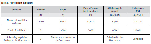
Pilot project is nearing its life cycle as all the activities are completed and the registration process in nearing its end. From the outset, there were project progress indicators against which the success of the project would be measured: i) number of land titles registered in project pilot areas; (ii) female beneficiaries. As of writing this paper, Pilot Project managed to achieve 125.2% completion rate on in the first indicator and 160% on the second indicator. Upon completion of the registration process, all indicators will be met.
Besides meeting the indicators, Pilot Project i) prepared the draft National Systematic Land Registration Strategy based on the findings of the project; ii) developed, tested and evaluated three different approaches to the systematic land registration; iii) calculated the time and cost of systematic land registration; iv) identified basic human and technical resources required to implement the systematic registration activities; and vi) developed and submitted for approval the legislative package designed to improve land registration system and facilitate the implementation of national rollout.
Paper prepared for presentation at the “2020 World Bank Conference On Land And Poverty” The World Bank – Washington DC, Copyright 2020 by author(s).


 (2 votes, average: 1.00 out of 5)


Leave your response!