| Navigation | |
Solving the GPS gap
|
Antonio Angrisano, Armando Pacifico, Mario Vultaggio
|
||||||||||||||||||||||||||||||||||||
|
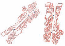
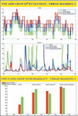
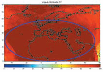
With a mask angle 40° GPS is inadequate to provide a continuous 3D positioning service, because very frequently there is a poor constellation coverage (VSN<4). VSN of super-constellation are between 5 and 11, so a continuous positioning service is guaranteed; the accuracy is not too good, because GDOP<6 probability is near to 40%. Fig.12: 3D model of a Naples street A further analysis is made considering a real environment rather than constant mask angle, building a 3D model of an urban area in AutoCAD (Fig.12); a map of historic centre of Naples is considered and the third dimension was obtained extruding the buildings contours with rough height values. In the 3D model three different observers are considered and for each of these VSN and GDOP are computed every 60 seconds for 24 hours. The observers (marked by blue spots on Fig.12) have different types of blocking situation; the first observer has a low masking angle (comparable to the blocking configuration with constant mask angle 15°), the second with a high masking and the third one with a very high masking angle. With a weak urban masking (observer 1 Fig.12) the GPS coverage is suitable to provide a good positioning service, the VSN is at least 5 and the GDOP value rarely exceeds 10. The augmentation constellations improve further the performances. The super-constellation works very well, the VSN is between 9 and 17 and the maximum GDOP value is about 5. With an high urban masking (obs.2 Fig.12 and results showed in Fig.13) the stand-alone GPS is not sufficient to provide good coverage performances; VSN>5 probability is near to 30% and positioning service is often cut off. In these masking conditions and with an observer at middle latitude, S-QZSS and EGNOS augmentations work differently; Fig.13: Naples coverage evolution (strong masking) With a very high urban masking (obs.3 Fig.12) the coverage performances of GPS are very poor, so the 3D position solution is often impossible or uncertain. GPS+EGNOS+S-QZSS constellation provide a continuous service but it couldn’t be guaranteed high accuracy: VSN>5 probability is near to 100% but GDOP<6 probability is about 55%. Service Area DefinitionThe obtained results encourage defining a “service area” (highlighted by ellipses in Fig.14) where both considered parameters (VSN and GDOP) reach appropriate values to guarantee availability and continuity of good satellite geometry. The following parameters have been chosen to define the service area: ConclusionsIn this paper the coverage performances of four constellations are analysed: GPS, GPS+EGNOS, GPS+S-QZSS, GPS+EGNOS+S-QZSS. Coverage is globally examined; over european region, different masking angle conditions are considered. With a not severe environment, GPS constellation provides good coverage performances. In moderately adverse environment (masking up to 35°), EGNOS and S-QZSS constellations are useful augmentations. A wide service area, including Southern Europe and Africa can be defined, where the superconstellation GPS+EGNOS+S-QZSS guarantees good performances in terms of visibility and GDOP. In the near future we wish to simulate a theoretic constellation with orbital parameters suited to improve coverage performances at high latitude. The obtained results encourage the implementation of a European program dealing with launching of some geosynchronous satellites in order to improve navigation satellite coverage over Europe. Waiting Galileo system deployment, such constellations could be used as gap-filler, or in future as backup system or as Galileo ERIS (External Region Integrity Systems) support. Fig.14: Service Area References• Japan Aerospace Exploration Agency (2007), Interface Specification for QZSS (IS-QZSS) |
||||||||||||||||||||||||||||||||||||
|
||||||||||||||||||||||||||||||||||||
|


 (No Ratings Yet)


