
IFEN GmbH appoints V3 Novus its distributor for India
iFEN Gmbh, Germany have appointed V3 Novus Pvt. Ltd. as its distributor for India for range of GNSS test equipment, including simulators capable of simulating all GNSS constellations and frequencies and a multi-GNSS software receiver.
V3 Novus is based in Bangaluru, India is an ISO 9001:2008 certified company …
DroneShield releases CompassOne
DroneShield Ltd. has released CompassOne, a self-contained navigation solution for fixed site, vehicle and marine applications. The device provides real-time militarygrade location, orientation and direction sensing for deployed static and on-thego assets. The device can be used both in counter UAS systems and general situations requiring satellite navigation. CompassOne can operate stand alone …

This paper highlights humorous research related to typical problems encountered in the workplace office environment, which are investigated using spatial tools, physics and artificial intelligence
Volker Janssen
Publications Officer, Association of Public Authority Surveyors (APAS), New South Wales, Australia
This is the second in a series of papers celebrating some of the weird and wonderful research findings hidden …
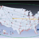
Timing is essential to our economic and national security. It is needed to synchronize networks, for digital broadcast, to efficiently use spectrum, for properly ordering a wide variety of transactions…

A number of challenges lie ahead when it comes to developing international standards for resilience
Guy Buesnel
PNT Security Technologist, Spirent
How the world became dependent on GNSS for PNT
The arrival of GPS kick-started a revolution. Using GPS was a cheap and reliable method of obtaining precise time and accurate position fixes globally. This revolution really accelerated when …
Planet has announced that it has expanded its contract with the NASA Commercial SmallSat Data Acquisition (CSDA) Program to provide access to PlanetScope imagery for scientific research use for all US Federal Civilian researchers and National Science Foundation funded researchers, including their contractors and grantees — roughly 280,000 eligible users.
This expands access on the existing contract that currently supports …
Esri has announced that in collaboration with federal agencies, it is opening up access to dozens of high-priority, high-demand national data layers, referred to by government users as National Geospatial Data Assets (NGDA). This development is critical for decision-making in areas of national concern like infrastructure development and disaster response.
The information being made available includes cartographic boundary …
China’s leading e-commerce platform for services, has introduced a new, self-developed drone model and announced plans for a drone logistics network pilot program in Shanghai. The announcement was made at the 2021 World Artificial Intelligence Conference (WAIC) in Shanghai, where Meituan demonstrated how drones and delivery riders could conceivably work together to deliver orders.
In a partnership with …
September 2021
Commercial UAV Expo Americas
7-9, September Las Vegas USA
…
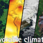
In this year itself, there have been many worrying events of extreme weathers.
In Greenland, for the first time rain fell at the highest point of its ice sheet.
If there are extreme level of flooding in Germany, China and Australia,
Then the Western US is facing one of …


 (5.00 out of 5)