

Volume XVIII, Issue 8, August 2022
Laser scanning in archaeology and cultural heritage documentation
Hina Pande, Poonam Seth Tiwari
and Shefali Agarwal
…
Northrop Grumman and Airbus MOU
Northrop Grumman and Airbus have signed a Memorandum of Understanding to address the United Kingdom Ministry of Defence (MOD) military satellite communication system requirements as an integrated team. The team will work together to address future aspects of the SKYNET program ensuring that …
Enhancing Living Atlas of the world
Maxar Technologies has announced that Esri, will enhance the World Imagery layer with higher resolution Maxar Vivid basemaps in the Living Atlas.
Esri will use Maxar’s Vivid basemaps to upgrade nearly half of the global landmass in Living Atlas from 1.2 m resolution to …
Consortium to develop future European land combat capabilities
Already member of the Consortium and part of the FAMOUS effort, Arquus has announced that it has been selected as a part of FAMOUS2, alongside coordinator Patria from Finland, fellow French major Defense company and partner Nexter, as well as …
Rwanda joins ADB supported remote data collection initiative
Rwanda has embraced the Remote Appraisal, Supervision, Monitoring and Evaluation (RASME) initiative, a tool that enhances project-related data collection in remote areas. It is the first East African country to do so and the seventh overall in the continent.
The …
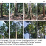
In this paper, we present, to our knowledge, the first validation of Lidar-derived AGB estimates of tropical trees using reference values obtained entirely from direct measurement
Andrew Burt
Department of Geography, University College London, London, UK
Matheus Boni Vicari
Department of Geography, University College London, London, UK
Antonio C. L. da Costa
Instituto de Geosciências, Universidade Federal do Pará, Belém, Brazil
Ingrid …

Addressing national datum modernisation, this paper presents a new approach to include static Network Real-Time Kinematic (NRTK) observations and their uncertainties in the survey control network of New South Wales (NSW), Australia.
Tom Bernstein
Senior Technical Surveyor in the Metropolitan Operations & Preservation of Survey Infrastructure team at DCS Spatial Services, NSW Department of Customer Service, in …

The remote sensors play a significant role in field archaeology as they offer non-invasive means for collecting data related to the physical and chemical properties of objects from space based, aerial and terrestrial platforms.
…
M-code compatible navigation system by Collins Aerospace
Collins Aerospace has introduced NavHub™-200M, the first non-ITAR vehicular navigation system for the international market compatible with Military Code (M-Code) receiver technology.It provides Assured Positioning, Navigation and Timing (APNT) capabilities while improving overall resistance to existing and emerging threats to GPS, such as jamming and spoofing. www.collinsaerospace.com
Small SWaP Time-space …


 (5.00 out of 5)