
DoD announces strategy for countering unmanned systems
On December 2 US Secretary of Defense Lloyd J. Austin III signed a classified Strategy for Countering Unmanned Systems. The strategy unifies the Department’s approach to countering these systems that looks across domains, characteristics, and time frames.
Unmanned systems pose …
Skykraft forms international partnership
Skykraft has announced the formal signing of Participating Project Partner Agreement for the “Demonstration of Collaborative Position Navigation and Timing (PNT) in Low Earth Orbit (LEO)” project. Supported by an International Space Investment (ISI) India Projects grant from the Australian Government, this initiative marks …
YellowScan teams up with Argosdyne
YellowScan has announced a collaboration with Argosdyne, whose latest UAV has officially received the C2 Class certification. The C2 Class certification permits closer operation to bystanders and in densely populated areas, meeting stringent European safety requirements. www.yellowscan.com
ESA and Japan expand collaboration …

The study aims to determine the floodplain hydraulic and hydrological spatial pattern using digital elevation models (DEMs) from topographic survey data.
JONAH Iyowuna Benjamin
Department of Surveying & Geomatics, Rivers State University, Port Harcourt, Nigeria.
URIAH Jeremiah
Office of the Surveyor General, Rivers State, Moscow Road, Port Harcourt, Nigeria
OKWERE Chiziandu Enyinda
Department of Surveying &Geomatics, Rivers State University, Port Harcourt, …

Appears that Geo-information sciences, Environmental sciences and Social sciences overrule the principles of the grammar of the English language.
Dr Mahavir
Former Professor and Dean (Academic), School of Planning and Architecture, New Delhi, India
I was going through a paper (Singhal and Gupta, 2024) when the word ‘imaginary’ in the abstract caught my attention. Somehow, the sentence was …
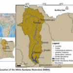
The purpose of this paper is to adopt a hydrological model combined with a GIS to assess the potential impacts of future Climate Change on the hydropower potential of the White Bandama River watershed in Côte d’Ivoire (West Africa).
Koffi Claude Alain Kouadio
Faculty of Biological Sciences, University of Peleforo Gon Coulibaly, Korhogo, Côte d’Ivoire African Centre …
ISRO’s Space Docking Experiment (SPADEX) marks a groundbreaking achievement, placing India on par with global leaders in space docking technology. Union Minister Dr. Jitendra Singh hailed the mission as a milestone while addressing the media today in New Delhi following the successful launch of PSLV-C60 from Sriharikota on December 30.
Dr Jitendra Singh said, the SPADEX …
Sandra Durán, an Assistant Professor in the Forest and Rangeland Stewardship Department, housed in the Warner College of Natural Resources at Colorado State University, is leading a groundbreaking research project funded by the National Science Foundation with a $299,551 grant.
Her project, “Linking functional biodiversity and airborne imaging to improve predictions of terrestrial ecosystem productivity across climatic gradients,” seeks to integrate …

Ancient buildings clustered on a hilltop are revealed by a narrow transect of lidar survey data. Lidar technology uses laser pulses to measure distances and create 3D models of specific areas. (Photo courtesy Luke Auld-Thomas)
Using laser-guided imaging to peer through dense jungle forests, Tulane University researchers have uncovered vast unexplored Maya settlements in Mexico and …
Astranis is the prime contractor for the U.S. Space Force
Astranis has been selected as a prime contractor for the U.S. Space Force (USSF) Space Systems Command’s (SSC) new Resilient GPS (R-GPS) program. It is one of four awarded an agreement to produce design concepts for R-GPS’ Lite Evolving Augmented Proliferation program. The R-GPS program was …


 (5.00 out of 5)