
The European Space Agency launched its star-surveying satellite Gaia into space, hoping to produce the most accurate 3-D map of the Milky Way and to better understand the evolution of our galaxy.

The U.S. Department of Transportation’s Federal Aviation Administration (FAA) released on November 7, 2013 its first annual Roadmap outlining efforts needed to safely integrate unmanned aircraft systems (UAS) into the nation’s airspace. The Roadmap addresses current and future policies

Bhuvan (www.bhuvan.nrsc.gov.in), a unique geoportal of NRSC that provide diversified geospatial services, is gaining popularity day by day and is much appreciated for its dynamic services. Initiated in 2009, Bhuvan has grown up rapidly and has made its impact on Indian user community. Expanding it’s state-ofart facilities and a datacentre at Hyderabad, Bhuvan is now extending geographically with its distributed architecture.
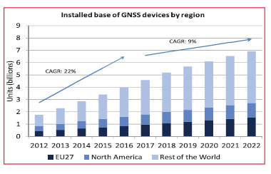
On the 15th of October 2013 the European GNSS Agency (GSA) released the latest version of its GNSS Market Report. The Market Report brings an updated and enhanced view of the GNSS global market “as it is experimenting rapid developments”. It encompasses a larger scope than before

In areas such as the environment of the city, for reasons such as multipath and GPS signal blocking, accurate position estimation is difficult only GPS system. The study such as GPS/INS, GPS/DR has been performed. Location estimation technique that combines vehiclemounted sensors, camera

China has invested enormous effort in manned space engineering. The Tiangong-1 and Shenzhou-8 have been launched, twice rendezvouses have been accomplished successfully. In order to meet the requirements of the manned space engineering on the TT&C network, and prepare for our country’s space station construction
The Eighth Meeting of the International Committee on Global Navigation Satellite Systems (ICG) was held in Dubai, United Arab Emirates (UAE) from 10 to 14 November 2013 to continue reviewing and discussing developments in global navigation satellite systems (GNSS) and to allow ICG members, associate members, and observers to address recent developments in their organizations and associations with regard to GNSS services and applications.
The Czech Office for Surveying, Mapping and Cadastre (COSMC), has implemented a web-based solution from Intergraph® for the distribution and publishing of national geospatial data. It includes high-performance image compression and delivery for handling big data on a large scale.
Highly automated vehicles require highly precise and redundant positioning and navigation systems in order to stay on track. With an innovative approach designed to meet this need through landmark-based navigation, Hartmut Runge from the Earth Observation Center (EOC) of the German Aerospace Center (DLR) has…


 (5.00 out of 5)