| Positioning | |
PPP using combined GPS/ GLONASS measurements
GPS was offi cially declared to have achieved full operational capability (FOC) on July 17, 1995, ensuring the availability of at least 24 operational, non-experimental, GPS satellites. To meet the future requirements, the GPS decision makers have studied several options to adequately modify the signal structure and system architecture of the future GPS constellation. The modernization program aims to, among other things, provide signal redundancy and improve positioning accuracy, signal availability, and system integrity (El- Rabbany 2006 ). Unfortunately, even with the modernized system, there exist situations where the GPS signal may be partially obstructed, e.g. in urban canyons, which in turn affect the availability and reliability of the PPP solution To improve the availability, positioning accuracy and reliability of the PPP solution, we propose to combine the GPS and GLONASS constellations. GLONASS has been gradually replenished since 2002 and has reached a total of 22 operational modernized satellites at present (Defraigne and Baire 2010; Springer and Dach 2010). In addition, Russia is planning to include eight different Code Division Multiple Access (CDMA) signals, along with its existing Frequency Division Multiple Access (FDMA) transmissions. This study investigates the effect of combining GPS and GLONASS dualfrequency measurements on the static PPP solution and its sensitivity to different processing strategies. Many data sets from IGS tracking stations distributed across North America were processed using the Bernese GPS 5.0 software package. It is shown that the addition of GLONASS constellation improves the number of visible satellites and geometry (PDOP) by more than 60% and 30%, respectively. Statistical analysis of PPP results shows that the performance of the combined GPS/GLONASS solution is superior to that of GPS-only solution. However, the improvement in the fi nal daily (i.e., with 24 hours of observations) solution is not signifi cant. System availabilityTo verify the improvement in the system’s availability, we used the GSSF simulation software to generate the global coverage and PDOP maps for the GPS and the combined GPS/GLONASS constellations, respectively, on November 9, 2010. As can be seen through the satellite coverage map (Figure 1), the addition of GLONASS constellation improved the global coverage by more than 60%. In addition, it improved the satellite geometry by 30% to 60% and eliminated dead zones (Figure 2). Modeling and processing of combined GPS/GLONASS PPP
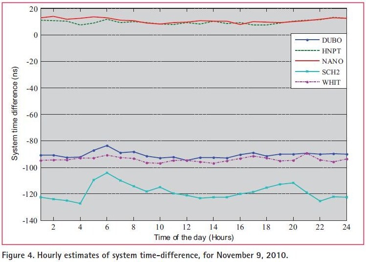
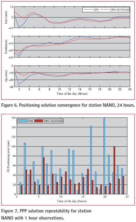
Data sets from fi ve International GNSS Service (IGS) tracking stations across North America (Figure 3) were acquired for November 9, 2010. Precise orbits and clocks corrections were obtained from the European Space Agency (ESA) to satisfy the compatibility conditions of orbit and clock corrections. Differential code bias (DCB) and ocean loading corrections were downloaded from the Center for Orbit Determination in Europe (CODE) and the Onsala Space Observatory (OSO) websites, respectively. Combined GPS/GLONASS PPP resultsEstimation of system time differenceThe estimation of system time-difference between GPS and GLONASS is an essential step for the combined GPS/ GLONASS standalone solution. Unfortunately, because there are no available calibrated values for the hardware delay of GLONASS receivers, the inter-system hardware delay will be included in the estimated time difference (Habrich 1999; Cai and Gao 2007). In the sequel, we will refer to the biased system time difference by TDGG. To verify the short-time stability of TDGG estimation, the combined GPS/GLONASS processing control fi le was used to estimate TDGG values every hour, for the fi ve selected stations, over the 24 hours under consideration. Figure 4 shows the hourly estimation of TDGG at the selected IGS stations over 24 hours. As can be seen, the estimated hourly values of TDGG agree to within 10 ns, except for station SCH2. For stations with same receiver/antenna brand (Table 1), the system time difference values agree to within 5 ns. However, discrepancies of up to 130 ns in the values of TDGG occurred between stations with different receiver/antenna confi guration, which refl ect the contribution of hardware delay. PPP results and analysisAs indicated earlier, data sets from fi ve IGS reference stations (Figure 3) were processed using the Bernese software. The obtained results show that there is a signifi cant improvement in the convergence and repeatability of the combined solution, especially in the fi rst observation hour. Figures 5 and 6 show the PPP solution convergence, fi nal solution accuracy and repeatability results are presented for station NANO as an example. Similar results were obtained for the other stations.
To examine the repeatability of the combined GPS/ GLONASS solution, positioning errors were estimated every hour over the 24 hours under consideration. Figure 7 shows the hourly positioning error for both of GPS-only and combined GPS/ GLONASS solutions. As can be seen, the combined solution has better repeatability in 75% of cases. ConclusionsThis study investigated the performance of dual-frequency GPS/GLONASS PPP solution. It has been shown that the addition of GLONASS constellation improved the satellite availability and geometry by more than 30%. This allows for precise surveying in urban areas or when the satellite signal is partially obstructed. In addition, the performance of the combined GPS/GLONASS PPP solution was found to be superior to that of GPS-only solution. While a few centimetre-level accuracy can be achieved within 30 minutes with combined GPS/ GLONASS PPP solution, it requires about 3 hours with GPS-only solution. AcknowledgmentsThis work was carried out at Ryerson University and was supported in part by Ryerson University and the Egyptian Ministry of Higher Education. The fi rst author acknowledges the fi nancial support provided by the Government of Egypt to carry out this reseacrh. Observation data and ESA Precise orbits and clocks corrections were obtained from the NASA/Goddard Crustal Dynamics Data Information System (CDDIS) website http:// cddis.gsfc.nasa.gov; differential code bias (DCB) were obtained for the Center for Orbit Determination in Europe (CODE) website http://www. bernese.unibe.ch/; and ocean loading corrections from the Onsala Space Observatory (OSO) website http:// froste.oso.chalmers.se/loading//, their contibutions are appreciated. ReferencesCai , C. and Y. Gao (2007). “Precise Point Positioning Using Combined GPS and GLONASS Observations.” Global Positioning Systems 6(1): 10.
|


 (6 votes, average: 1.17 out of 5)


Leave your response!