Articles in the News Archives Category

Bharat-VISTAAR’-a multilingual AI tool
The Union budget of India proposes ‘Bharat-VISTAAR’(Virtually Integrated System to Access Agricultural Resources) – a multilingual AI tool that shall integrate the AgriStack portals and the ICAR package on agricultural practices with AI systems. Bharat-VISTAAR is expected to • Enhance farm productivity through scientific, data-backed …

A holistic summary of important criteria needed for safe and successful flights
Tito Jun T. Tidula
A former UAV operator/ controller who operated both fixed wing and multirotor drones and is currently a faculty member in the Department of Agricultural and Biosystems Engineering, College of Engineering and Information Technology, University of Southern Mindanao, Kabacan, Cotabato, Philippines
Rezin G. …
PointX and StellaX to smart lawn mowing
MOVA has integrated CHCNAV PointX integrated satellite ground service and the StellaX high precision positioning chip into its NAVAX 5000 AWD intelligent robotic lawn mower, unveiled at CES 2026. The integrated positioning solution is designed to support centimeter level accuracy for wire-free mowing, without requiring users to install …
SpaceX launches next-generation Italian COSMO-SkyMed satellite
The third satellite part of the COSMOSkyMed Second Generation (CSG) constellation, owned by the Italian Space Agency and the Italian Ministry of Defense, built by Thales Alenia Space, a joint venture between Thales (67%) and Leonardo (33%) and operated in orbit by Telespazio, a joint venture between Leonardo (67%) …
GNSS and PNT security deployed at World Economic Forum
Dimetor is providing its NAVSentry airspace situational awareness system to the World Economic Forum annual meeting, in support of the Austrian Armed Forces. The meeting is taking place this week in Davos, Switzerland, close to the Austrian border. NAVSentry is an AI-powered platform for detecting GNSS disruptions …
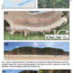
A case study on a beach and rocky cliff
Álvaro Gómez‑Gutiérrez
Instituto Universitario de Investigación Para el Desarrollo Territorial Sostenible, Universidad de Extremadura, Avda. de la Universidad S/N, 10003 Cáceres, Spain
Manuel Sánchez‑Fernández
Instituto Universitario de Investigación Para el Desarrollo Territorial Sostenible, Universidad de Extremadura, Avda. de la Universidad S/N, 10003 Cáceres, Spain
José Juan de Sanjosé‑Blasco
Instituto Universitario de Investigación …
Deep learning warm starts for trajectory optimization on the ISS
New research, published in and presented at the 2025 International Conference on Space Robotics (iSpaRo), introduces a system designed to help Astrobee, a cubeshaped, fan-powered robot, autonomously navigate the International Space Station. The ISS is a complex environment made up of interconnected modules filled with …
UAVOS partners to advance HAPS technology
UAVOS has announced the successful completion of a test flight of Mira Aerospace’s High-Altitude PseudoSatellite (HAPS) ApusNeo 18, with UAVOS providing full engineering and technical support. One of the key objectives of the flight was to evaluate the jointly developed optoelectronic, gyro-stabilized aircraft POD (Payload Onboard Device) by obtaining …
SiTime takes on GNSS threats
SiTime Corporation has launched the Endura® temperature compensated oscillator (Super-TCXO®), ENDRTTT, for PNT applications. When GNSS signals are dropped due to unavailability or degradation – including signal jamming or extreme environmental conditions – holdover maintains timing stability locally to enable uninterrupted network operation. The ENDR-TTT Endura Super-TCXO provides up to 20x …
e-GEOS and Umbra partnership
e-GEOS and Umbra have signed a multi-year strategic agreement to jointly develop innovative geospatial intelligence solutions for customers worldwide.
The deal will combine the high revisit frequency, resolution and wide coverage offered by the First and Second Generation COSMO-SkyMed satellites – a SAR program of the Italian Space Agency and the …


 (5.00 out of 5)