| Surveying | |
Mapping of the Mount Everest – An awe inspiring history!
This article attempts to take a closer look at the mapping history of the Mount Everest region from its history to the present day. The survey and discovery of Everest by using classical trigonometric methods to modern-day space technology and 3D mapping is examined in this article |
 |
|
Mount Everest is often considered “a symbol of something impossible”. For mountaineers standing atop Everest, near the Nepal-China border on the huge ice block that caps its peak, it is a life-time dream. Before climbers scaled the world’s highest mountain, several surveyors sacrificed their lives surveying and mapping in order to contribute to the worlds’ understanding and knowledge of this unique and beautiful geographic icon.
Since Everest is the world’s highest mountain it has been constantly studied from various aspects. This article attempts to take a closer look at the mapping history of the Mount Everest region from its history to the present day. The survey and discovery of Everest by using classical trigonometric methods to modern-day space technology and 3D mapping is examined in this article.
The icon
This iconic peak was known by various local names before it earned global fame as the highest peak. It was only after The British Great Trigonometric Survey of India determined a heigh the late 19th century that the local peoples recognized the fact that their mountain truly was the worlds’ height. Europeans had prepared a rough sketch of the mountain from the northern side of Everest using their own resources before naming the mountain as the world’s highest peak.
Being the highest among many of the world’s highest peaks, fosters tremendous interest among geographers and the general public. Various survey authorities from across the globe began to publish the maps of Everest and its environs soon after it was recognized as the world’s tallest mountain. And with the advent of the internet, and open-source data, publishers seem to be competing in publishing maps of the region for various purposes ranging from the scientific to news stories.
As awe inspiring as the mountain is, so are the maps. From the hand-drafted to digital 3D models and detailed studies of the geology and tectonic elements, these have become more readily available. But for the foundation for these maps, the rich history of the work of intrepid surveyors, mappers, geodesists, geologists, geographers, and cartographers has often gone unheralded. Do not take those maps for granted; they were borne of the skill, innovation, and bravery of many, over several centuries. There have been so many wonderful and informative maps of Everest and the region; we offer a few notable maps and their storied creation.
Early mapping in the region
Jean-Baptiste Bourguignon d’Anville (1697-1782) was an influential French geographer that is credited with greatly improving the standards for map making at the time. d’Anville is considered by some to be the first Westerner as a person to conduct a survey of Everest, in the beginning of the eighteenth century. Between 1708-1716, Jesuit missionaries led by d’Anville performed the first survey by Westerners of China. The survey included the Hindu Kush Himalayan range and produced the Royal Map of the Chinese Empire.
In the course of this ambitious undertaking, d’ Anville’s team had conducted a tentative survey of the region that includes what it now is known as Mount Everest. The map printed in Beijing in 1718 covers the mountain range without determining summits of mountains. The Everest region was named Jumu Lungma (see Image 1) in Chinese language (but not specifying individual peak names). This same section of the Himalayas in northeast Nepal and south-central Tibet of China is what is now known as the Mahalangur Himalayan (Mahālangūr Himāl) range. Many of the maps of these remote and difficult to traverse regions were more like rough sketches [Ward. M.P. Mapping Everest. Cartographic Journal 1994 Jun;31(1): 33–44].
Nepal’s mapping records indicate that Charles Crawford, a member of the British- Kathmandu mission, was first Westerner to conduct a survey in the country. Between 1802-1803, Crawford prepared a map of the Kathmandu Valley for the first time, also determining the latitude and longitude of the valley. Further, Crawford calculated heights of mountains seen from Kathmandu, the capital city of Nepal.
As has been the case throughout history, science and mapping initiatives can be disrupted by geopolitical events. A few years after Crawford’s survey of Kathmandu valley, relations between Gurkha (Nepal) and the British worsened because of Anglo-Gurkha War that lasted until 1816. Because of the war, foreigners were barred from coming to Nepal. Special permits were required to enter the Kathmandu valley until 1950, the year when the Rana Oligarchy ended.
The Great Trigonometrical Survey
Spanning seven decades of the 19th Century, one of the most ambitious surveys in history was conducted, under the auspices of the East India Company, which sought to provide the geodetic framework to survey the entire Indian sub-continent.
Between 1847 to 1850, the Great Trigonometric Survey observed the locations and heights of some 79 mountains situated in the Hindu Kush Himalayan region. Most of those mountains are in Nepal. The survey was conducted from North Indian territories—Bihar, Patna and Lucknow— while surveyors from British-India were deployed, for triangulation surveys. They observed “Peak XV” from more than 108 miles to 118 miles far from the summit of Mt Everest. Their survey, and computations by Indian mathematician Radhanath Sikdar, proved that Peak XV was the highest peak.
The second of four successive leaders of the survey was British surveyor and geographer Colonel Sir George Everest CB FRS FRAS FRGS. The initial height of the mountain was computed from observations made during his tenure, but it was his successor who put forth Everest as the namesake. Naming the mountain presented difficulties as there were multiple local names for the mountain under consideration. Later Peak XV was officially renamed as MOUNT EVEREST only after a meeting of Royal Geographic Society in 1865 in London. It is said that Everest himself was not in favor of this as he felt that his name was difficult to pronounce in local languages.

Modern age exploration
As the mountain became the focus of expeditions to reach the summit, surveyors would often accompany support teams. This year marks the centennial of the one of the first comprehensive, and arguably the most important, Everest mapping expedition of the modern age. It employed photography, and modern surveying instruments and techniques and has served as a foundation for all that followed.
The 1921 Everest Expedition took a long and arduous, fourmonth route in a wide arc around the region, from Darjeeling India, north to Lhasa Tibet, then southwest to the Rongbuk Monastery—at the time one of the last outposts before reaching the mountain. Major Wheeler, a Canadian citizen serving in British army, would later serve as Survey General of British-India from 1941-46. A Nepali surveyor working for British Survey of India- – Lalbir Singh Thapa, and surveyors Gurljar Singh, Turbaj Singh and a photographer Abdul Jalil Khan were also part of the same survey team.
There were also two British surveyors, who were also accomplished mountaineers. This combination of surveyor and mountaineer was not uncommon during the serval centuries of using triangulation for mapping—someone has to scale those high vantage points and perform the surveys. The survey team was mobilized to pursue three goals: prepare an Everest map, explore unidentified areas, and prepare a detailed map of the Everest Base Camp and surrounding areas. The team had started their survey work from the state of Sikkim in northeast India. The survey data and sketches by Major Wheeler were the basis for the famed 1921 expedition map (see Image 4) that would inform subsequent climbing expeditions, surveys, and mapping campaigns.
A young George Mallory, schoolteacher and experienced mountaineer also accompanied the expedition and assisted in the survey and logistics. Three years later, Mallory and a colleague attempted to be the first to scale Everest, only to have apparently perished near the summit. The mystery of their disappearance was not solved for over 75 years when remains were finally found, though we may never know if they made it to the top.
Aimed at assisting a 1922 Everest expedition, the Royal Geographic Society had published a map of Everest showing the route to Rongbuk Glacier in 1922. In 1925, the Royal Geographic Society prepared a map of Mount Everest based on photos and ground data captured in different seasons and over various time periods. Surveyors were successful in publishing a map of Everest on the scale of 1:63360 with a 100-meter contour interval (Image 5).
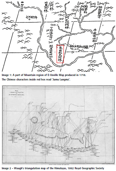
The Survey of India had first released an Everest map at a scale of 1:126720 (One inch equal to 2 miles) in 1930. The level of detail across the maps was inconsistent, so some of the places and streams in the Everest region were not named.
As Europeans and other foreigners were banned from entering Nepal at the time, many climbers attempted to ascend Everest from the north. The map (Image 6) shows camps set up by George Malory’s team for one of his Everest expeditions.
From the Air
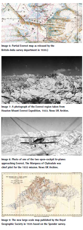
By the 1930’s, aviation had evolved to the point where the high altitudes and harsh conditions could be overcome, and the dream of flying over Everest had been realized when two planes, a Westland PV-3 and Westland PV-6 (twoseater heavy bi-planes) landed in Pune India. Named the Houston Mount Everest Expedition, the team achieved the first successful flights over Everest on April 3, 1933.
Two aircraft had successfully, for the first time, captured both horizontal and vertical photos of Mount Everest and surrounding areas. They rounded the summit of Everest for 15 minutes, capturing hundreds of aerial photos. AR Hinks, a cartographer, and the then Secretary of Royal Geographic Society, along with then society’s draftsman HF Milne processed those photos for a new Everest map.
The addition of aerial photos, and later lidar and satellite images and radar data, revolutionized mapping of the region. But even those advanced technologies required precise and accurate geodetic references, and framework.
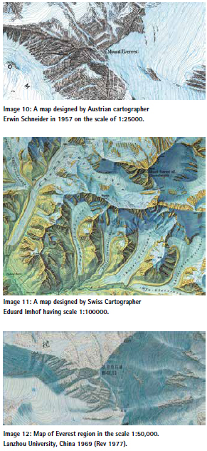
Continuous updates
Surveyor Michael Spender was included in 1935’s British expedition team led by mountaineer Eric Shipton. He was equipped with a Zeiss photo-theodolite and Wild phototheodolite used by Royal Geographic Society, which was carried by the famous climber Tenjing Norge Sherpa. This was his first time on an Everest expedition, serving as a highaltitude worker and porter. Afterward, Spender successfully published a new large-scale map of the northern ridge of Mount Everest. Photography was performed on the scale of 1:20000 from the base of Rongbuk Glacier to the top of Everest.
Map Source: The Himalayan Journal, Records of the Himalayan Club Edited by Kenneth Mason, Vol. IX, 1937.
Survey work also featured in expeditions organized in 1936 and 1938. Noel Odell, a geologist, was also part of the expedition groups who later returned with valuable firsthand data on the geography and geology of the Everest region.
For the first time in 1945, an Everest map covering both the Nepalese and Tibetan sides was prepared. This map was prepared by compiling aerial photos taken in 1933 from Houston Mount Everest Expedition, and maps prepared by Michael Spender in 1935 [MP Ward and P Clark; Everest 1951: Cartographic and Photographic Evidence of a New Route from Nepal; in Geographical Journal 158, 47-56, 1992].
A survey from the Nepalese frontier was performed for the first time in 1951, as part of an expedition that also included the famed climber, Eric Shipton. The survey was conducted from southern ridge [K Mason, The Representation of Glaciated Regions on Maps of the Survey of India. Professional Paper No 25. DehraDun, 1925]. Though an Indian surveyor named Nath Singh was the first to visit the Khumbu Glacier for the purposes of surveying, he was not able to complete the work due to low temperatures.
Charlie Ivan, one of the famed climbers of 1953’s first ascent of Everest expedition climbed some of the mountains surrounding Everest in order to acclimatize. During these ascents, he collected valuable ground data. Based on this new data, Survey of India revised its first map published in 1930.
A year after the first successful expedition to summit Everest in 1953, a joint team comprising the Everest expedition of New Zealand and British climbers conducted a photo survey of Everest and surrounding areas. Later, in 1961, the Netherlands published another map of the Everest region by incorporating details of previous photo surveys [E P Hillary and W G Lowe, East of Everest. Hodder & Stoughton, London, 1956]. Between1954-55, the French Federation of the Mountain published a map of Everest and the inner Makalu region on the scale of 1:50000.
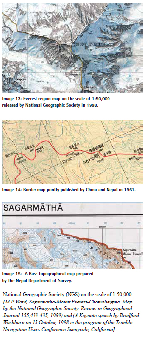
In 1957, Erwin Schneider, an Austrian cartographer, unveiled larger maps of the entire Khumbu region on the scale of 1:25000 with a 20 meter contour interval (published in English and German). After the first historic and successful Everest ascent expeditions in 1953, Survey of India calculated and published the new height of Mount Everest; 8848 meters. After releasing the new height, Survey of India released an updated, comprehensive map in 1954. This map was later downscaled to 1:50000 and was released in 1963.
In 1959, Survey of India released topographical maps encompassing all of Nepal, which was published in 274 grid sheets. These maps were compiled and prepared based on aerial photos captured between 1956-1958, and ground surveys of the Everest region. Later, in 1960, Swiss Cartographer Eduard Imhof published a map of Everest region on the scale of 1:100000, with a widely lauded, visually attractive cartographic features. This map sold out quickly, despite a relatively high price tag for that time.
In 1961, GS Holland and GR Crone, cartographers of the Royal Geographic Society, published another map of Everest on a scale of 1:100000, showing areas of Namche Bazaar to Rongbuk Glacier in the north, Rolwaling of Dolakha in the west and Tashi Lapcha Pass in eastern region of Solukhumbu [G S Holland and G R Crone, ' A New Map of the Mount Everest Region; in Geographical Journal 128, 54- 57, 1962]. Cartographers had collected new survey data from several locations and compiled previous data from others to prepare this map. The Royal Geographic Society in 1975 published and updated map incorporating some new data.
Likewise, a team of Chinese cartographers led by Chen Jiaming, professor at Lanzhou University, prepared an Everest map in Chinese language in 1977. Chinese surveyors had worked for 10 years on this map starting from 1966. The Royal Geographic Society of London later translated the contents of this map into English which is still being displayed at the Hall of the Royal Geographic Society.
In 1980, Bradford Washburn, director of the Boston Museum of Science, sought helicopter flight permission from Nepal’s Department of Survey to prepare an Everest map on the scale of 1:10,000 with a 20 meter contour interval, aimed at avoiding mapping errors and making it useful for all in the future. The Government of Nepal granted permission through the Survey Department.
Washburn employed Nepali and Chinese Surveyors for ground verification. Using sets of aerial photographs captured by aerial survey and ground verification, an Everest map was prepared by Washburn and his team, and they published that map through the National Geographic Society (NGS) on the scale of 1:50,000 [M P Ward, Sagarmatha-Mount Everest-Chomolungma. Map by the National Geographic Society. Review in Geographical Journal 155,433-435, 1989) and (A Keynote speech by Bradford Washburn on 15 October, 1998 in the program of the Trimble Navigation Users Conference Sunnyvale, California].
Nepal Survey Department
Against tough competition among global power centers in mapping the mountains of Hindu Kush Himalayas, home to Everest, Nepal was a late comer in emphasizing the importance of surveying and mapping science, and formalizing mapping activities. Gurkha armies who fought with distinction in World War I and World War II on behalf of the British Empire experienced the importance of maps. They studied maps and learned surveying skills during their deployments. The Nepal army started mapping and surveying work using plane tables in 1923 when Former Field Marshal Judda Shumsher was Shree-3 Maharaja, prior to becoming Prime Minister and Rana (ruler).
In 1957, Nepal established the Survey Department under the Nepal Army. From the very beginning of its establishment, the department focused on preparing the official cadastral maps to help regulate land tenure and land administration. In the meantime, a border marking agreement was signed between Nepal and China in 1960- 61. Under the agreement, a joint map having a scale of 1:500000 was prepared. Before Nepal measured Everest, Survey of India in 1954 determined 8848 meters as its official height. But Nepal-China border map in 1961 reads Everest height is 8882 meters as measured by Sydney Burad in 1904. The reason behind mentioning the Everest height as 8882 meters in the joint map is not clear.
Since the peak of the Everest sits very close to the Nepal-China border, a strip map was prepared to show the northern and southern sides of the mountain border in the course of designing the joint-map. A separate topographical mapping unit was established later under the Department of Survey, Nepal in 1970, and at that time essential infrastructures were inaugurated to prepare topographical maps.
In 1978-79, the second Nepal-China joint border survey was conducted, and a new border map was jointly prepared on the scale of 1:50,000. In that map, the height of Mount Everest is noted as 8848.13, which was measured by the State Bureau of Surveying and Mapping of China in 1975. Nepal seems to have agreed to that.
From 1978 to 1984, the Survey Department published land resource maps of Nepal in collaboration with the Department of Forests (later to become the Department of Forests and Soil Conservation). The land resource map of the Everest region was also prepared and published.
Since 1996, aerial photographs have been taken for the preparation of base maps of the eastern part of Nepal under the Eastern Nepal Topographic Mapping Project with support of the Finnish Government. Later only in 2001, a detailed base map of the Everest region was also prepared on scale of 1: 50,000.
Presently, the Department of Survey has prepared maps on the basis of satellite images and previously created contour data.
The quest for a definitive height
There is an enduring fascination with the “height” of Everest. And indeed, a lot of mapping data has come from various expeditions for which the high-ascents were not the sole motivation, but that which gained the attention of general public.
For example, the height of the mountain was discovered incidental to a much broader mapping project. In 1852 when Radhanath Sikdar, an Indian-Bengali mathematician, rushed into the room of Sir Andrew Waugh of the Great Trigonometric Survey of India and exclaimed, “Sir, I have discovered the highest mountain of the world.” Sikdar was employed as a “computer”; he had been processing observations the survey had performed with the optical instruments of the day, like Great Theodolites that weighed half a ton and had to be carried by teams of 12. Designated at the time as “Peak XV,” the official height was given as 8,840 meters (29,002 feet). Everest has been measured repeatedly since, using all manner of instruments, including satellite radar. GPS was employed, for official measurement purposes, for the first time in 1999, though there is evidence that some low-precision recreational GPS units may have been carried up the mountain prior to this.
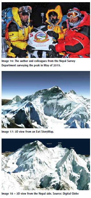
Subsequent surveys refined this to the broadly-accepted official elevation of 8,848 meters (29,029 feet), from a 1955 Indian survey, and backed-up by a 1975 Chinese survey. More recently, the multi-year Sagarmatha Height Measurement project, that performed geodetic surveys in and around mountain, included an ascent and survey of the summit. I lead the Nepal survey team especially for the survey observations on the summit in May of 2019; you can read my account of the climb and survey here.
The technology employed to take the measurements was GPS (actually called GNSS now as multiple satellite navigations systems are used) from Trimble, and ground penetrating radar (to determine the thickness of the ice on top of the peak. A second survey by a Chinese team in 2020 used similar technologies. By mutual agreement between China and Nepal the new official height of 8,848.86 meters or 29,031.69 feet (height above sea level) was announced jointly on December 8, 2020.
Digital and 3D
Theis iconic mountain continues to inspire awe; both in terms of science and the desire of many to summit. The technologies of surveying and mapping have steadily evolved, but some elements remain the same. Namely the acts bravery in collecting ground data, as the respective Nepal and Chinese surveys in 2019 and 2020 demonstrated.
Everest has now been mapped by remote sensing and direct observation in great detail, and in 3D. Cartographers, even those who have never set foot in the region, continue to create valuable and data rich maps leveraging ever increasing resources and data that are freely available online. This data has been processed into models that you can download and have a 3D printer make you scale replica. There are even virtual reality (VR) versions developed for gaming engines, where you can do a virtual ascent.
While all of this downstream lateral activity is interesting, the core data still holds fundamental value for science and management of this natural wonder and its environs. As with any lofty pursuit, practitioners are said to be standing on the shoulders of those who came before. And in the case of mapping this mighty mountain, some of those shoulders have stood higher than anywhere else on earth.
The full story of the mapping of Everest is not simply a matter of technology. Fundamentally it is the story of human connections to the mountain, the explorers, surveyors, climbers, and the keepers of oral and written tradition. Narratives may change but none can erase the history. While only known to the western world as the world’s highest peak for less than two centuries, its rich history holds its own significance for all—Nepalis and people from across the globe.
Ed. This article has been published courtesy of GoGeomatics (gogeomatics.ca).


 (6 votes, average: 4.67 out of 5)


Leave your response!