| GIS | |
Implementations in planning of public services in Riyadh
This plan aims to improve the level of these services in the city, fill the existing gap and identify the future needs of Arriyadh |
 |
|
The provision of public services is considered as one of the basic goals which city managements all over the world seek to realize. In particular, the provision of public services indicator is considered as one of the most important urban indicators which reflect the quality of life for city residents. In this regard, the High Commission for the Development of Arriyadh, that is responsible for planning and comprehensive development of the city, has approved an overall plan for coordination and provision of public services in Arriyadh city.
This plan aims to improve the level of these services in the city, fill the existing gap and identify the future needs of Arriyadh. The plan also includes the establishment of a database at city level, which will include all information, spatial data for public services in terms of locations, distances and ownership, and any other information that may help the relevant agencies to develop their future plans and priorities.
The plan was prepared in coordination with relevant public agencies through a technical committee formed for this purpose. This committee comprises 15 representatives from public agencies concerned directly with public services in the city, where these agencies in addition to the High Commission for the Development of Arriyadh city include Arriyadh Municipality, Ministry of Education, Ministry of Health, Ministry of Interior (General security, Arriyadh Police, Arriyadh Traffic Police Department, General Directorate of Civil Defense, Passport Department), Ministry for Islamic Affairs, Endowment, Dawa and Guidance, Ministry of Higher Education, Technical and Vocational Training Corporation, Saudi Red Crescent Authority, Central Department of Statistics and Information, and Saudi Post.
The plan included the collection of data related to the quantity and quality of public services from different public agencies, and a field survey of different public services facilities in the city of both public and private sectors was also carried out. This included information related to ownership, metadata, number of labors and beneficiaries of these facilities, as well as identifying their locations, such as if they were for developed locations or lands allocated for public services or if they haven’t been developed in approved plans.
The phasing in the plan included the following:
a. Phase 1: This phase is concerned with the collection of information and an overall field survey for the public services in the city.
b. Phase 2: This phase is concerned with the evaluation of the current situation and the development of planning standards. The numbers of currently-needed public services and their distances have been identified as well as the future needs till 1450H.
c. Phase 3: This phase is concerned with the development of an executive program to achieve public services needs in Arriyadh city.
Methodology
The Establishment of Geographic Database
The provision of a geographic database for public services in Arriyadh city is one of the main requirements of the plan, where it provides spatial data about public services as well as achieving the following:
• The geographic distribution of public services in terms of quality and quality at city level.
• Compare provision of public services in Arriyadh city with those in cities across the world.
• Estimate the level of these public services provision with the population needs according to the city, sub municipalities and neighborhoods.
• The provision of scientific bases which help the decision-maker to improve of public services in the city.
• Identify the future qualitative and quantitative needs of these public services.
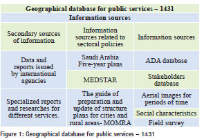
Based on the above, the importance of database provision is clear, because it contains accurate and updated information of public services and their locations in the city, that was based on the overall geographic database existent in the High Commission for the Development of Arriyadh.
The work methodology in this plan was based on the review of all information sources, data, and aerial images, as well as data of social and demographic characteristics and five-year plans of the Kingdom and MEDSTAR.
Data collection and field survey
The available data from basic sources and before the field survey was classified into several levels as follows:
• Services without spatial coordinates and metadata.
• Services with available spatial coordinates but the service metadata is not available.
• Services without spatial coordinates but the service metadata is available.
• Different information and statistics (urban, social, population, etc.).
After the data collection process, the data is indexed, classified and numbered. This is followed by the analysis process, and from the comparison process, the following were found:
• Identify the services points which will be targeted during the field survey.
• Identify the survey area.
• Identify the time framework for the field survey process.

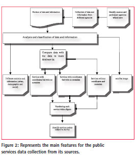
Figure (2) represents the main features for the public services data collection from its sources.
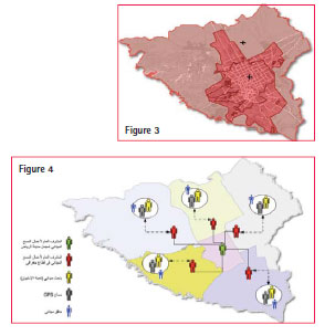
Due to the need for updated spatial metadata for the public services in Arriyadh city, the filed survey process has been carried out in accurate and scientific manner. The field survey covers the development protection limits for Arriyadh city with an area estimated at 5,400 km2 (figure 3).
To ensure the compatibility of the field survey deliverables with database requirements, specifications and analysis requirements, it was necessary to develop a detailed methodology for the field survey that deals with the field survey deliverables, questionnaire design, survey area division, identify and train the required staff, and identify the mechanism of coordination between the survey teamwork and download and verify data.
The field teamwork is formed from 24 groups distributed all over Arriyadh city, where each group includes a surveyor, researcher, field auditor and watchman.
The field survey is carried out in accordance with the recognized scientific bases when carrying out such studies, including ensuring the collection of accurate information and filling the questionnaire for the required service. Then locations and coordinates of service and the metadata related to each service are ensured, as well as the quality control process in collecting, classifying and downloading information to the (GIS). These processes are done in accordance with international standards.
The survey teamwork provides surveyors with the necessary maps, navigation equipment and coordinates, so the meters of equipments used in monitoring the public services points were set, where these specifications should be unified in all equipment in order to ensure the accuracy and harmony of monitoring works.
The teamwork has carried out an inventory of all required services and has monitored their points on the ground. After that, a coding system for these services has been prepared by identifying a ‘CODE’ for each service. This code is introduced (GPS) during the monitoring process to facilitate the data classification and utilize them in (GIS) programs. The table 1 shows the way of classifying the service type and its code:
The field teamwork has carried out the Cadastral Survey and registered metadata of the location, code, number and service location which were monitored in accordance with the coding system approved for services by using (GPS Garmin Etrex) with accuracy of 2 m.
Registration of survey information and data in geographic database
By the end of the field survey and Cadastral Survey, the (GIS) teamwork has registered the metadata digital information to be processed in the geographic database framework.
After the collection, revision and registration of information, the most prominent characteristics of the current situation of these services have been reviewed and compared with the international indicators. Then, the current situations have been evaluated and analyzed through the revision of available data and in the light of the approved planning standards. The degree of these services are measured, and the suitable distribution at city level, sub municipalities and neighborhoods. The indicators related to service quality have been concluded and compared with measurements targeted from services agencies and international standards, particularly in terms of medical and educational services.
This was carried out on two levels, the first is the statistical level and the second was through comparison with the current standards (not updated). These standards depend on the scope of service in meters, as well as the serviced population and the land area allocated for each individual by using (GIS) as follows:
• The first level: The statistical tables for the current situation of services which show the facilities number for each service and the extraction of urban indicators and compare them with the current indicators.
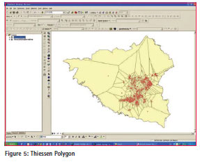
• The second level: The analysis and comparison with current indicators that require identification of service scope for each service, and calculate the serviced population and land area in which the service is provided. This process is done through Thiessen Polygon, in which the following are carried out:
– Calculation of the scope of service a mathematical equation which calculates the average rate for distances from the service centre to the periphery range.
– Calculation of serviced population.\
– Calculation of land area rate of service for the population.
– This information is collected within a specified range, then formatted into (EXCEL) and included (Pivot tables) to check their compatibility with the current standards.
Analytical model
In the light of the above, an analytical model has been established by (GIS) to evaluate the current situation and estimate the future needs of public services in terms of number and distance through the following inputs: 1) The available data for numbers and distances of public services:
– The main database existent in ADA.
– Databases existent in agencies involved.
– Aerial images for successive periods.
– Field survey.
2) Numbers and distribution of current population and predictions:
3) The planning standards to provide public services, in this plan, planning standards for the provision of public services in Arriyadh city have been revised and developed based on the following considerations:
– Evaluation of compatibility of the current situation of public services provision with the current standards that are applied when lands are planned by Arriyadh municipality.
– Comparison of the current standards with the local and international standards in other similar cities.
– Consideration of urban fabric of neighborhoods and the demand level compared to the available supply.
1. Analysis of current situation of public services and the extent of current standards applications.
2. Comparison of current standards with local and international planning standards in other similar cities.
3. Consideration of urban fabric of neighborhoods and demographic distribution and demand level compared to available supply.
Developed planning standards
It was found from the analysis that there was a multiplicity in standard sources used by agencies related to public services, and there is a variance in the effectiveness of standards currently applied, in particular, standards used in planning lands in the city. For example, it was found that the standard used for primary schools for boys is the provision of a school for each 3.600 people and this is considered as a very high standard compared with other cities where it has been modified to become one school for each 6.000 people. While the standard used for hospitals was specified by the provision of one hospital for each 160.000 people, is considered as a suitable standard, so it was adopted in the developed standards.
It was found that the current standards focus on the required services at the level of neighborhoods, where there are no standards related to traffic centers, universities and public libraries and others, as suitable standards have been developed for these services and included with the developed standards. In the light of this, developed standards of public services related to Arriyadh city have been obtained jointly with the relevant services agencies which participate in the preparation of this plan, where the evaluation of the current situations and specification of the future needs of public services in Arriyadh till 1450H was based on these standards.
The most prominent results and issues of public services
The identification of deficit and surplus process in the provision of public services is based on viewing the current situations in terms of quantity and quality related to the number of services and coverage level, as well as the land distance available to fill the current and future gap. To realize these goals, a comparison was carried out based on population and current population densities, calculation of density average in all neighborhoods and the adoption of revised standards used for all services on sub municipality level.
Results have been presented in detailed reports of the plan through charts and tables which show surplus and deficit for each service on all sub municipalities level, that will facilitate the development of plans in future to fill the gap and improve the level of public services in the city. The standards proposed for services that are included in the study have been applied to identify the current deficit and surplus. The most prominent results are as follows:
• Mosques are properly provided at city level, although there is variance in provision or deficit at neighborhood level.
• Educational services are considered as the service that suffers most from deficit and poor distribution at city level, whether kindergarten or primary and secondary schools for boys, also schools for girls suffer from deficit, particularly secondary schools. Universities suffer from poor distribution as they are concentrated in the north and central part of the city.
• Medical services suffer from poor distribution where some sub municipalities suffer from deficit.
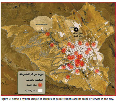
• Security services and police stations, particularly civil defense, suffer from a big deficit at a neighborhood level.
• There is also a deficit in the provision of parks and recreational services, especially playgrounds and public parks city level.
• The percentage of public services located in leased buildings rise where it is estimated at (46%). This influenced the provided service and location appropriateness, and an unwanted situation resulted from the lands which were allocated for public services and still owned by the private sector. This is in addition to the change of some land uses allocated for public services to other uses, the lack of financial support necessary for expropriation or the implementation of public services buildings in allocated lands. Through the evaluation of the current situation of public services, some issues that face the city have been identified as follows:
• Change uses of some lands allocated for public services, where the total distance of public services lands established for other uses is estimated (at 31 km2), whether for leasing or concession by service agencies. The percentage of leased buildings of public services is high where the buildings of public services located in leased buildings is estimated at (46%).
• The lack of lands owned by public services agencies, particularly Ministry of Education, Ministry of Health, and security agencies.
• Regarding the need for unifying planning standards related to public services, it was found that no conformity of previous standards of public services in the city compared with international standards, as well as concentrating on the provision of services at local level, and ignoring other levels such as hospitals and universities.
• The weak coordination mechanisms between executive agencies of public services in terms of planning and executive aspects related to priorities and providing the necessary financial support.
• The clear lack of data and information related to the public services that are not connected with spatial data through (GIS). This led to lack of knowledge of agencies about their service locations and slowdown of monitoring, implementation and updating aspects.
• The expected impact of new policies in providing public services (medical insurance, Wasil postal service, E-government, electronic education and distance education). This reflects on the standards related to providing these services and their scope in the city.
Executive program
The executive program reflects the executive plan for coordinating and providing public services and its management in Arriyadh city, where it is concerned with filling the gap in public services and fulfilling the current and future needs till 1450H. The program represents a planning reference for relevant executive agencies related to public services. It includes the following:
– Identify priorities: Priorities have been identified according to seven indicative atlases that show type, volume and location of services required at neighborhood level for each service. This is in accordance with time priority identified by four phases till 1450H and estimated costs to provide these. The identification of priorities was based on the level of requirement for each service, taking into account the aspects related to availability and quality of the service, current and future population, as well as urban growth trends.
– Available means for lands provision: The continuation of the current situation of reserving a percentage of lands when planning for public services, and in case of unavailability of lands, ownership for targeted locations is expropriated. The establishment of land bank at city level will allow land swap between public services agencies. Contract with the private sector to provide necessary lands is followed by the commissioning, maintenance and operation of services against money paid periodically, and then the ownership is transferred to the government.
– The available means for finance: The continuation of government expenditure where services are implemented from the public budget, are approved for different service agencies in accordance with a schedule consistent with the implementation phases included in the implementation program. Participation of the private sector in financing, building and operation, followed by ownership of services is then transferred to the government. In the joint development with developers, the developers of comprehensive development projects of residential and commercial complexes are committed to build public service facilities located within their projects.
– The available means for implementation and management: The implementation and management of public services facilities is carried out through public agencies. Participation of the private sector in financing, building and operations, is followed by transfer of ownership of services to the government after an agreed period (BOT). This is in order to mitigate the burdened budget, and improve level of services such as establishing new postal, educational and medical services. Transfer of the responsibility of management, operation and development to the private sector by management contracts for a period of time are made against an amount of money according to the performance improvement. Leasing assets owned by the government, such as medical and educational services. The executive plan, particularly the approved projects included in the operational plans of agencies related to services, can be monitored through ‘performance indicators’ for each of the approved services projects by measuring the scale of achievement in these projects according to the approved schedule.
Recommendations
• Approve the database related to the public services in Arriyadh city, and design a joint portal between relevant agencies in order to update data continuously and periodically, monitor and follow up on the implementation of projects, and measure their consistency with the planning standards. This must be consistent with the trends of the establishment of E-government.
• Approve the developed planning standards included in the plan and consider it as the main reference for lands planning and distribution of services locations in Arriyadh city.
• Emphasize on stopping transfer of lands allocated for public services in approved subdivisions (schools, hospitals and others), and be committed to the decrees of Council of Ministers.
• Establish ‘the Land Registry Center for public services lands in Arriyadh city’ that is concerned with the inventory of public services lands and specify their ownerships, transfer them to identified services agencies and set procedures necessary for swapping these lands in accordance with needs and surplus for each agency at neighborhood levels.
References
The High Commission for the Development of Arriyadh (ADA) , Planning and Projects Centre, 1433H, the executive plan for the coordination and provision of public services in Arriyadh city. First edition. Arriyadh: The High Commission for the Development of Arriyadh.
The paper was presented at 9th National GIS Symposiun in Saudi Arabia at Damman during April 28-30, 2014.


 (2 votes, average: 3.00 out of 5)


Leave your response!