
Articles in the Mycoordinates Category

INDUSTRY | LBS | GPS | GIS | REMOTE SENSING | GALILEO UPDATE
wireless adapter can take advantage of its positioning technology and locate a user. Users
Opera Software and Skyhook Wireless …
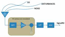
The current panorama of navigation satellite systems is rich of proposals for novel modulations and bands, to be prospectively used in the current and incoming systems. In this perspective, the know-how on the inherent nature of signals and systems is a fundamental resource to proactively cope with the multiple aspects of interaction and integration among signals, services and applications…

Of course, it would be extremely rare, when any GPS surveying and/ or “navigating” to the North Pole is undertaken. One such opportunity occurred In April 2005. British explorer Tom Avery in his effort(s) to recreate Adm. Robert Peary’s epic journey of April 1909 to North Pole took GPS to navigate himself…

Indian Institute of Surveying and Mapping (IISM) is the country’s premier institution for human resources development in the realm of surveying and mapping in its modern incarnation. IISM recognizes that the cutting edge in the process of development is information dissemination. Hence, its efforts of generating awareness among various organization and training its manpower in modern trends in Surveying & Mapping like GPS, Total Station,…
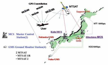
The Multi-functional Satellite Augmentation System (MSAS) is a Japanese Satellite Based Augmentation System (SBAS) [1] which provides Differential GPS (DGPS) corrections and is designed to supplement GPS by reporting and monitoring the reliability and accuracy of GPS signals in real time. MSAS consists of two satellites, (MTSAT-1R at 140E longitude and MTSAT-2 at 145E longitude), four Ground Monitor Stations (GMS), two Master Control Stations (MCS),…

GPS import in India was derestricted in Jan,04 – Bal Krishna, june’05
If we go strictly by rule that exists on paper, making a GPS operational without a license from WPC is not allowed – P. K. Garg, July’05If GPS needs a license to operate in India then what is the procedure
for obtaining that license – Sudipto Roy, Jan07
It was easy to have detected Sumatra Offshore Earthquake from GPS – Shunji Murai and Harumi Araki, July’05 Rapid data acquisition and information services have contributed greatly to the rescue work and disaster relief efforts in Wenchuan Earthquake – Deren Li, July’08

Basic Act on the Advancement of Utilizing Geospatial Information was approved by the cabinet in Japan last year. It states the promotion of the various kinds of the applications of geodetic information in both private and public areas to realize the convenient and safe society. The supplementary budget to save the economical crises this year in Japan prepares a lot of money to promote the utilization of geographic information. In order to realize such society in near future,…

Fifty months ago, the journey started.
With passion, confi dence and conviction.
All the while, we navigated through technology trends.
Raised issues and followed up.
Captured the pulse of the market.
Added dimensions to the domain (refer page number 16).
Presence was felt, impact is notable.
And the journey continues…

Almost 20 years ago, as a Surveyor in private practice, and as someone who had a passing interest in politics, I presented a paper at a surveying conference, titled “Surveying the Political Landscape. At the time I had no ambition to stand for political office as I was more than fully occupied with my Surveying and Mapping business which was busy adopting new technologies such as Geographic Information Systems and Global Positioning Systems…
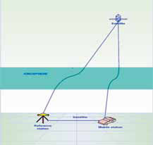
Global Positioning System (GPS) is currently one of the most popular global satellite positioning systems due to global availability of signal and performance. GPS employs two carrier frequencies which is L1 and L2 allowing receivers equipped with dual frequency operation to be used. Due to the inhomogeneity of the propagation medium in the ionosphere, the GPS signal does not travel along a perfectly straight line [1,2]…


 (5.00 out of 5)