| Surveying | |
Automated digital workfl ows and transactions using machine readable language to represent 2D & 3D cadastral surveys
Readers may recall that in last month we published an article underlying survey database technology and workfl ows. As indicated, we present here the article on how the process is facilitating the representation of the survey plan in a machine readable fi le that is
|
 |
|
Background
Security of tenure and incontestable spatial definition of land is the major contributor to the economy of developed states and is the economic springboard for developing states. E-governance technology is now a major component of administering all aspects of this sector.
In the survey and mapping domain, digital transmissions and workflows have been in place for a considerable time but for the most part the ‘digital’ component has been an electronic image of a ‘hard copy’. The automation of digital workflows and transactions is identified as a natural progression in efficiency as computing capacity and more intelligent data structures develop.
The survey title plan is a complex document that has a legal role as a supporting document to a title, and a spatial role that once validated, is guaranteed by government so spatial quality is critical. Validation of this type of survey information has always been a complex and laborious manual process.
Over 10 years ago the Australian Intergovernmental Committee on Survey & Mapping (ICSM) began a process to initiate a standard ePlan LandXML structure to represent the complete content of a survey plan in a machine readable format for digital automation purposes across all State jurisdictions.
NSW has developed an ePlan system based on the ICSM LandXML version which represents every component of the survey plan image. A Registered Surveyor submits their LandXML file to the Titles Office portal and the process then immediately checks the plan content for compliance with over 100 business and survey rules followed by spatial validation with a survey database of existing plans.
The Northern Territory (NT) has utilised a simpler structure used by Commercialoff –the- Shelf (COTS) software. The NT has reduced the machine readable content to that which is only relevant to the processes of updating and spatially upgrading the current cadastral database and satisfying business transactions for new Title creation. Formats to represent 3D Strata/Apartment Titles are being tested. Very few strata plans currently have a height (z) component but each unit will be uniquely represented in the cadastral database and height attributes can be added to existing strata plans as needed for 3D modelling requirements but new strata plans will require height definition attributes at lodgement.
This presentation outlines the background to the processes that has been successfully implemented in those two State jurisdictions. Geodata Australia technology has contributed to some of the outcomes outlined in this presentation.
Technology is facilitating e-governance and is also driving the transition from measurement based title systems to position based title systems, so it is important that there is also consideration as to whether existing survey practises, statutory requirements and even the content of a survey plan will still be relevant in the digital future. Spatial infrastructure like Continuously Operating Reference Stations (CORS) will challenge current Statutory Regulations developed for measurement based technologies.
Current technology determines survey methods and title definition
The available technology at the time has always determined survey and title processes. Early title definition of ownership was described by words or diagrams based on recognisable physical bounds (monuments) – rivers, mountains etc. As further division was required artificial monuments were placed and technology provided circumferenters and chains to measure and records of those were retained as a proof of the ‘metes’. Written text became the most effective way to represent a survey inside the legal process by means of a Metes and Bounds description. As technology progressed measurement accuracy increased and copying technology saw diagrams and survey plans become the preferred method of representation for all stakeholders. Through all this the Torrens Title edict of ‘Monument over Measurement’ has remained.
Today, measurement as we knew it is changing as GNSS and the coordinated database underpins land administration. The survey plan in the hands of a Registered Surveyor still provides the core survey information and intuitive skills to spatially locate the boundaries of a property, but in a non legal scenario the database is rightfully or wrongfully challenging that role. The intensity of that challenge is increasing to where a database of a high spatial quality is starting to provide the coordinates that will be the evidence for a Registered Surveyor to reinstate a boundary on the ground. The content of the modern digital survey Plan has been driven by the requirements to identify a new Title, the metadata associated with that Title and the survey information that satisfies plan examination scrutiny that adjoining titles are not spatially compromised. This content was designed to fit with historical technologies that are being superseded around us like CORS. Another aspect of the plan referred to above is that it is a local solution only linking that plan to the adjoining titles. Spatial technology is now providing global solutions so investigation of that progression will make surveyors relevant for the future to deal with precise coordinate issues like datums & time.
Initially GIS cadastral databases were based on mapping tools such as digitising charting maps. Whilst updating with modern accurate survey data can directly populate a precise cadastral database, older survey plans representing current titles are not of the same precision, so ‘fitting’ those titles into a seamless fabric is difficult. All the survey issues to consider are variable and any method to categorise precision in the database can only truly be done with a comparison of the coordinates of a particular point with those determined by a Registered Surveyor in the field.
A tool that links survey data and accuracy is the Survey Database technology ‘GeoCadastre’ and the ESRI ‘Parcel Editor’. The difference with previous mapping based cadastral databases is that the original parcel ‘ground’ dimensions stated on the plan are always stored as the defining parcel dimensions and are used in the adjustment to generate parcel coordinates. The process also automates resolution of azimuth, measurement types (Feet, links etc) and grid conversions. The ‘grid’ dimensions of the parcel in the cadastral fabric model will vary from the original ground dimensions as all the parcels are adjusted to provide a seamless geodetic ‘fabric’.
In areas of modern development with accurate surveys, that adjustment will be minimal but in areas of older inaccurate subdivisions the difference between the plan dimensions and the model dimensions will be greater as more accurate representation of the distances between monuments is provided by the fabric database.
Geodetic survey control points or accurately coordinated cadastral points are the location foundation of the Parcel Fabric Survey Database. It contains all the components that a surveyor would expect in a dynamic survey database with several levels of validation.
Electronic lodgement and automated examination of survey plans
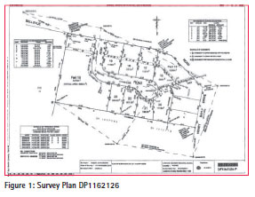
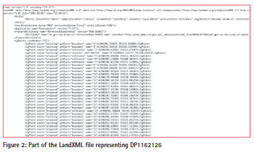
All title boundary measurements, other survey measurements and jurisdictional information can now be represented in a text file as machine readable data. This opens the door to automated examination and transaction processes. Diagrams 1 & 2 represent the old and new way of survey plan lodgement in NSW.
An XML representation of the plan goes through initial automated examination processes that can happen in seconds. After the file passes the initial examination, the survey is then matched by joining the new parcel corners with those in an existing cadastral Survey Database. Transformation residuals of that matching points provide metrics for spatial validation. The business outcome has been that most of the manual assessment tasks have been automated and in the best case scenario (matching a new plan to an accurate locality database) the time to create new titles can be reduced to several days rather than 1 – 2 months as per existing manual processes.
In Australia, the original government ePlan process began ten years ago with a committee under the auspices of the Intergovernmental Committee on Survey & Mapping (ICSM) to initiate a standard ePlan LandXML structure to represent the complete content of a survey plan in a machine readable format for digital automation purposes. The committee developed a standard schema which was based initially on a variation of LandXML that has matured from a basic to an expanded schema when the various state entities (including New Zealand) have added requirements to meet their individual requirements. The ICSM committee engaged the major survey software vendors to provide an internal tool to the surveyors to output an ICSM LandXML compliant file to lodge with the relevant Titles Office. Due to each jurisdiction having different data protocols, the vendors needed to develop separate tools for each jurisdiction. At this stage only 3 States have progressed to an implementation stage based on the ICSM schema while the others are reviewing that progression.
In New South Wales (NSW) and the Northern Territory (NT) processes of this type are being implemented with the assistance of the Geodata Australia team, but with different approaches as outlined further below. One point of difference is the validation tools in the NSW system are built into the portal for online validation whereas in the NT the surveyors are required to complete similar validation in GeoCadastre software prior to lodging.
The real benefit is a self validation for the surveyor. As many ‘errors’ in plans are minor, early statistics are showing that the initial validation is finding in the order of 50% to 80% of the errors that would normally be found in the departmental manual examination process. So they are being highlighted by the technology before it is accepted by the Titles Office.
NSW
In NSW the ICSM Australian LandXML structure has been in implementation for several years and is in ongoing development for better presentation outcomes. Upon lodgement the LandXML file is converted to a COTS Survey Database format for processing using a tool developed by the Geodata Australia team. NSW LPI also uses on-line tools for automated Portal examinations. The underlying survey database for spatial matching purposes is generated in GeoCadastre and the outcome of the registration process is then migrated to the Survey Database managed by the ESRI Parcel Fabric platform.
The automated Portal examination process checks the survey for compliance with over 100 business and survey rules that include:
• Correct XML syntax and correct XML entities
• Accuracy of parcel and traverse closes
• Currency of geodetic survey control coordinates
• Statutory requirements for survey reference marks
• Correct jurisdictional names (County, Parish and Local Government names)
If a survey plan file fails any of the tests the surveyor can withdraw the file, rectify them as identified in a comprehensive report and re-lodge the file. This could take a matter of minutes and the Plan file then goes on to the next stage of spatial assessment using Parcel Fabric based tools.
For the NSW Titles Office there were initial concerns that the bulk of their plan examination team had been in that role for many years and there may not have been an acceptance of a digital way of analysis rather than the manual way they had been doing the spatial examination for many years. These concerns were not warranted as once the experienced examiners understood it, they could see how the process simplified their jobs.
The process has meant that in optimum conditions a less experienced plan examiner can verify that the file passes all the automated portal examinations and then undertakes the process of matching the topology to an underlying accurate Survey Database fabric. If the residuals at all points are within a certain tolerance (10-15mm in urban areas) and the underlying principles of land title boundary definition are met, they are able to register that plan without the involvement of experienced plan examiners. Any jurisdiction that has an aging plan examiner workforce would recognise how this technology will benefit a diminishing resource at a time where the government business pressure is to do more with less.
Whilst the NSW Titles Office has been vigorous in assisting surveyors to utilise the technology, acceptance and take-up by the Survey profession has been slow. While the concept of a faster turnaround is accepted, the implementation involves time in understanding and setting up of the survey detail to match the ICSM schema, so there is an orientation component that costs the surveyor that they must overcome. Currently 78 LandXML plan files have been lodged and registered through the NSW Titles Office Portal.
NSW Registered Surveyor Graham Hall of Craig & Rhodes Pty Ltd who has lodged over 25 LandXML files comments that “once you understand the process, have the systems in place and there is no duplication with manual workflows, efficiencies for the surveyor and all stakeholders should be achievable”.
The future scenario would be that the cost component of manually drafting a survey plan would be replaced by the time taken to populate the respective attribute fields that would otherwise represent geometry or text components that would have been shown on the plan.
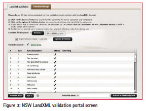
If preparation of the LandXML digital output is greater than the manual methods, that cost should be passed on to the client and justified by the fact that they will benefit in the longer term by faster Title creation. Diagram 3 is a screen shot of the automated LandXML Validation tool. This is accompanied by a PDF file which lists the full description checked.
The process offers considerable benefits to the NSW Titles Office so they will push for it to become compulsory in the future.
Northern territory
The Northern Territory (NT) has to deal with extremes in cadastral definition, from standard urban parcels to Pastoral Leases in remote areas that can cover over 5000ha with 80km boundaries that are historically defined by Latitude & Longitude. Computations of long lines also introduce the geodetic complication that each survey line is an arc and will have different azimuths along its length.
The NT is fortunate that it has been implementing the Parcel Fabric Survey Database process for over 20 years to generate a Numerical Cadastral Data Base (NCDB) built from plan measurements. It has nearly completed the manual data entry of all the current survey plans for each parcel (historical plans not entered) into the NCDB so they have a foundation for modern digital survey processes using intelligent XML data structures. Where no existing survey plan is available the existing Digital Cadastral DataBase (DCDB) data has been reverse engineered into the NCDB as the current parcel.
Recognising how technology will drive measurement and Title definition, over 10 years ago the NT enacted legislation to allow coordinates to be the prima facie evidence to define the location of a Title. The NT Surveyor-General recently ‘declared’ 3 Coordinated Survey Areas to come under that legislation. As all measurement in rural and remote areas of the NT is already done by GNSS, work practises will not change. It will mean that the effort required in computations and statutory survey outcomes is significantly reduced.
In the NT a less complicated ePlan standard that escapes the burden of the requirements of other jurisdictions inherent in the ICSM LandXML standard has been implemented. Amendments to the NT Survey Practice Directions have been made to enable all surveyors to lodge single survey plan files or larger survey databases that hold many plan files that have externally been joined and adjusted to geodetic control in a fabric. These will be lodged in a GeoCadastre file format which is the same as the ESRI Cadastral Editor XML (CEXML). This is also a point of difference between the ICSM ePlan Process which has been designed for the lodgement and examination of one survey plan file. The NT system will expand the capability of spatial examination and efficient updating of the NCDB with larger survey databases. In the near future, the Surveyor General will only accept lodgement of survey plans electronically through the departmental portal.
In the NT there will be no legislative requirement for the survey plan to be a completely digital based plan. In this process, data that is only relevant to updating and upgrading the cadastral database and satisfying business transactions is required to be held in the lodged XML file. Other plan data which is only relevant to surveyors for boundary reinstatement and plan examination purposes is still available in a ‘tiff’ format.
The NT Department of Lands, Planning and the Environment has met the challenge in the remote areas to not only electronically represent the geodetic computations, but also integrate the historical survey records which will be captured on an as required basis. Extensive ground traverses have been done over many years to locate the lease boundaries on the ground. Those survey plans defining the boundaries have been registered at the Titles Office, so the marks placed by those surveys legally define the boundary and will be represented in the NCDB and by future title coordinates.
The authoritive survey and title database will be accessible to surveyors from a web-based service that will maximise the benefits of real time technology. This however is still a number of years into the future.
Northern Territory – 3D Cadastre
Whilst there are only a couple of cities or towns in the NT that have multi story buildings, the data structure and capability to represent 3D title entities is being developed within the GC technology for the NT as part of the digital workflow implementations.
‘Strata’ plans defining a cubic space will be included in the NCDB. Current Strata Plans have limited measurement information in either x, y or z directions. Each cubic entity is defined by digitising the footprint of the structural elements that provide the legal definition of the Strata boundaries, being the internal faces of structural walls, floors, ceilings and other features supporting and defining that cubic space. Initially that geometry representation will be transferred to the NCDB so each unique legal cubic entity will be spatially represented in the NCDB. When required, lower & upper height attributes can be added when they are needed or become available so that 3D modelling of that data in a GIS is then possible.
3D Strata Titles are an internal division of a current parcel in the NCDB. That NCDB parcel location will be spatially affected as the NCDB is constantly upgraded. Horizontal geometry connections to the 3D Strata Titles ensure that as the external parcels are more accurately located, the position of the internal 3D Strata footprints will also be spatially upgraded. Adjustments in the NCDB will only affect the X,Y or horizontal location as there is no need for adjustment of height definition.
As the detail of the process is refined over time, strata boundaries may be populated from various sources if it is of benefit. Initially, hard copy building plans could provide better dimensions to define the digitised 3D entities. The next progression would be to import digital boundaries from CAD drawings or extracted from detailed Building Information Models (BIM). The Spatial definition of the cubic space may be held in an xml format so it will be readily accessible to more advanced 3D modelling technology.
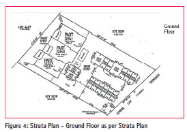
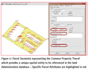
Whilst these sources would provide accurate design dimensions, if a higher level of accuracy is required to produce a spatially authoritive dataset a Registered/Licensed Surveyor would be required to validate that boundary location. This would be a significant undertaking and it is doubtful it would be commercially justifiable, particularly in the NT. Figure 4 shows the Ground Floor Level of the Strata Plan. Figure 5 highlights the digital geometry of the Common Property ‘parcel’ which has a legal status as a parcel in the Strata scheme. In the future surveyors will be required to populate all the X, Y & Z components of the strata parcel in a format of this type. The parcel identified is Common Property so no Lower & Upper Height limits have been noted like a normal strata parcel which is limited in height, usually by floor & ceiling levels.
The future
The focus of the digital survey tools discussed is representing relevant survey plan data in a machine readable format that facilitates the automation of existing survey quality validation processes. This will then flow through to improving the quality of the Cadastral Database. This is not an issue for new development areas but it is important that the best data structure is put in place for efficiently upgrading areas of older surveys where accuracy is either uncertain or poor. If the data is in the Survey Database structure, the digital workflows outlined in this paper will assist in the most efficient spatial upgrading with the least resources.
Many of the processes being implemented in NSW and NT have been built on COTS processes and the different jurisdictional needs are managed by linking to a specific Configuration file that automatically sets up the tables required to populate statutory or other specific jurisdictional needs.
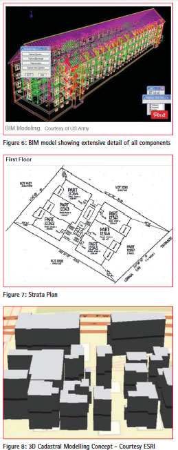
The 3D cadastral model is now in demand to match advances in 3D visualisation and administration technology. Since the Strata Plan Legislation in NSW was enacted in 1961 the format of the Strata Title Plan has changed very little. It is an elegant way to represent a complex ownership arrangement. Thick lines represent walls and it was defined that the face of the structural wall, floors and ceilings is the limit of private ownership while the wall itself is deemed Common Property. Survey measurements were only required where no structure existed and rather than being related to the cadastral definition of boundaries, external private cubic spaces were defined relative to recognisable structural features in X,Y & Z directions. Many other jurisdictions follow a similar protocol.
BIM models (See Figure 6) now offer a wealth of detailed information for construction as shown in the Figure 6 below. The issues of the location of Common Property and infrastructure like pipes & cables that service all the separate Strata Titles spaces are well defined and provide clear visualisation for trouble shooting at the design and construction stage. The BIM could be a useful spatial data source but they are only currently generated for a small percentage of Strata Plans.
The Strata Plan (See Figure 7) provides the antithesis of the BIM where a basic diagram effectively identifies the legal entities and implied easements protect the private services that run throughout the Strata scheme.
To add a 3D component to the cadastral database for digital visualisation and administration of legal cubic spaces, we believe the pragmatic approach being adopted by the NT can begin the process. It is difficult to see where a higher level of definition of actual Strata unit boundaries would be commercially justified. Figure 8 shows a conceptual 3D model built from a 2D footprint with upper and lower heights defining cubic spaces.
Quantifying a pragmatic level of ePlan and 3D cadastral database development with all the stakeholders is the key to engaging them. Complexity in the process will delay implementation and alienate many stakeholders. We can move forward with complex modern technologies guiding our processes but integrating the manual outcomes that define our past and current lands must also be addressed in a pragmatic way.
Acknowledgements
Dr Michael Elfick – Registered Surveyor, Survey Database Software Developer, Wallalong, NSW
Mark Deal, Chris Wilcox, Hwan Choi – NSW Land & Property Information – Eplan Project
Craig Sandy – Director Surveys, Land Information Department of Lands, Planning and the Environment, Northern Territory
Graham Hall – Registered Surveyor – Craig & Rhodes Pty Ltd, Sydney, NSW Sean Morrish – 3D Product Engineer, ESRI, Redlands, California, USA
Keera Morrish – Instructor, ESRI, Redlands, California, USA
CADASTRE 2034 – Cadastral Reform and Innovation for Australia – A National Strategy Intergovernmental Committee on Survey and Mapping.


 (42 votes, average: 1.19 out of 5)


Leave your response!