Study on Galileo services consolidation
The European GNSS Supervisory Authority has issued a call for tenders for a study on Galileo service consolidation. The general aim of the project is to conduct a critical review of the current Galileo integrity baseline concept, based on the evolution of integrity requirements for Galileo, and receive proposals for new global Galileo integrity concepts. For details visit: http://ted.europa. eu/udl?uri=TED:NOTICE:039425- 2008:TEXT:EN:HTML

Iran’s space ambitions ride on Safir
Iran has successfully recently launched a sub-orbital rocket called Safir (Envoy). The payload that was launched by Safir sent real-time data back to earth from about 250 km. Next, a satellite called Omid (Hope) will be placed in a near-polar orbit satellite, at an altitude of 650 km and will pass over Iran six times every 24 hours.

Jharkhand state in India goes online at the grassroots level
Common service centres would be set up at each of the 4,562 panchayats in the state by soon where villagers can avail services like registration of certificates, filing commercial taxes among others. According to R. S. Sharma, Secretary of IT, 3000 of such centres has already been set up. Use of GIS for digital mapping of districts shall also be done to locate the villages and also to calculate
the amount of rainfall an area receives in a year to facilitate irrigation. Water harvesting mapping using GIS shall also be emphasised. www.telegraphindia.com/

India orders over one hundred SIGMA 95 navigation systems
Hindustan Aeronautics Ltd. (HAL) of India has just ordered from Sagem Défense Sécurité (SAFRAN Group) more than 100 SIGMA 95N navigation systems. These systems will be used on the Indian Air Force Sukhoi fighters and the Tejas fighters from the Indian LCA (Light Combat Aircraft) program. SIGMA 95N is a standalone inertial laser gyro navigation system with integrated GPS/Glonass. It brings highprecision navigation and a high degree of operating flexibility to combat aircraft.

2.2 million cars in Europe have a telematics device
According to Berg Insight, 2.2 million passenger cars in Europe had an on-board telematics device at the end of 2007. It forecasts that the major breakthrough for telematics in Europe will come with the introduction of the eCall system proposed by the EC, which holds a high probability of becoming a reality in the early 2010s. berginsight.com

Topcon and Sokkia merge
The merger between Topcon Corporation and Sokkia Co, Ltd, both with corporate headquarters in Japan, was confirmed on 5 February. Both companies are the two largest Japanese manufacturers of survey equipment. Sokkia will become a wholly owned subsidiary of
Topcon Corporation.
April 2008
MELAHA 2008
13-15 April Hurghada,
Egypt
ain@aast.edu
http://www.ainegypt.org
GEO-SIBERIA 2008
April 22 – 24, 2008, Novosibirsk , Russia
strutz@sibfair.ru
http://geosiberia.sibfair.ru/eng/n
Toulouse Space Show’08
22-25 April Toulouse, France
contact@toulousespaceshow.eu
http://www.toulousespaceshow.eu/toulouse_space_show.htm
May 2008
IEEE/ION PLANS 2007
Co-sponsored by IEEE and Institute of Navigation
May 5-8, 2007
Monterey, California, USA
http://www.plansconference.org
June 2008
International conference: “Studying, Modeling and Sense Making of Planet Earth”
1 – 6 June, 2008
Department of Geography,
University of …

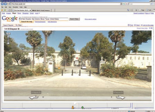
Does Google have multiple standards?
The Pentagon has banned Google from taking photographs and video footage of US military bases after images showing important security features of a base in Texas appeared on the company’s website. The Defence Department’s ultimatum came after images showing entry gates, barriers and buildings within the Fort Sam Houstan base, in …

Over the past 100 years the world’s total population has quadrupled – from 1.6 billion to 6.6 billion. (Footnote: Population Bulletin, “World Population Highlights: Key Findings From PRB’s 2007 World Population Data Sheet” http:// www.prb.org/Articles/2007/623WorldPop. aspx.) In many parts of the world we see growing poverty. We now face increasingly worrisome resource constraints and environmental difficulties…

Although Global Navigation Satellite Systems (GNSS) technology is developing rapidly, the major disadvantage of GNSS will still exist even when the European Galileo system is fully operational, that is, signal blockage due to obstructions and the low power of the signals. The combination of GNSS with a self-contained inertial navigation system (INS) provides an ideal solution, which can not only address the weakness of GNSS and but also bound…


 (5.00 out of 5)