

South Africa has received the first images from its Sumbandila satellite. Sumbandila means “lead the way” in one of South Africa’s indigenous languages, Tshivenda. Using that theme, South Africa’s Science and Technology Minister Naledi Pandor said South Africans must never be shy to compete against the best countries in the world. She was …
PCI Geomatics announced the availability of an upgrade to its remote sensing and image processing software Geomatica®. Version 10.3.1 is the latest release available which includes imaging tools for GIS as well as additional satellite and aerial sensor support.
Satellites fully supported in this release include THEOS (Thailand Earth Observation System), GOSAT (Greenhouse Gases Observing Satellite), …
Vol. VI, Issue 2, Feb 2010
Zip
Defining civil PNT requirements
John W Lavrakas
MISSION 2020: Land Titling Project
P Misra
GNSS support to canine search and rescue
José Caro and Manuel Prieto
Fuzzy strong tracking unscented
Kalman filter
Dah-Jing Jwo, Fong-Chi Chung and Shih-Yao Lai
My Coordinates
EDITORIAL
Book
Land administration for sustainable development
Conference
The First Asia Oceania Regional Workshop, Survey camp
News
INDUSTRY | GPS | GALILEO UPDATE | …
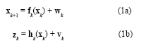
The Global Positioning System(GPS) (Brown and Hwang 1997; Farrell and Barth 1999; Gelb 1974) and inertial navigation system (INS) have complementary operational characteristics and the synergy of both systems has been widely explored. An integrated GPS/INS system is typically carried out through the extended Kalman filter (EKF). The EKF is the approximate nonlinear filters which linearizes the system…
Honeywell announced that its Bendix/King by Honeywell AV8OR handheld GPS is now available for helicopter operators. The AV8OR is a portable touch-screen GPS for use in the car or in the air, with real-time weather capability, moving-map navigation and video-in capability. Its large 4.3-inch screen can display weather, from Honeywell’s KDR 610 or the WxWorx …

Earthquakes, landslides, avalanches, collapsed buildings… There are many situations in which people could suddenly become trapped and unable to free themselves without the assistance of search and rescue professionals…
Karnataka, India: A central government appointed probe panel has found “sufficient evidence” of land grabbing against the controversial Karnataka High Court Chief Justice, PD Dinakaran. The probe panel report is likely to be based on satellite images of the village land, revenue records submitted by the state officials and statements of villagers and the version …
Bentley Systems announced breakthroughs in 3D GIS software to support the design and operation of intelligent cities. Bentley’s intra-operable portfolio of software features lifecycle support across all classes of intelligent infrastructure, including land management, power generation and energy delivery, water and wastewater networks, roads, bridges, rail, communications networks, and buildings. The just-released V8i versions of …
Chinese mapping authorities have worked out about 70,000 topographic charts and image graphics for the rural areas in the past year, as an effort to ensure each village has one map of its own. The State Bureau of Surveying and Mapping has also made more than 300 thematic maps and developed 18 GIS tailored for …
In Africa, convergence has been happening between the web and geo as open source solutions such as MapServer, traditional GIS data has been made accessible to millions of people through the web. These innovative tools have inspired the proprietary GIS companies as well. So indeed, geo and web have really taken off, according to Mark …


 (5.00 out of 5)