| Application - New | |
Application of a multi-sensor approach to near shore hydrography
A cost-benefi t analysis |
 |
|
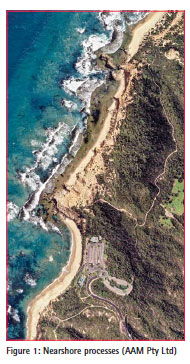
The shallow water coastal environment characterises the critical interface between activities at sea and on land. Much of the economic activity at sea that is now being recognised as the Blue Economy takes place ‘out there’, away from our focus of attention on land. But all of it, at some stage, in order to be relevant to our lives, comes to the shore, and in doing so it passes through the shallow water coastal environment. This is the bit of the maritime world that most of us can associate with and are, at least, aware of. This is also the zone where growth in the Blue Economy and expansion from the land into the sea meet, and where there is potential conflict of interests and increasing pressure in terms of resources, one of which is space.
In order to manage and regulate a space it is first necessary to have some idea of what that space consists of. This is a given on land and yet seems not to be at sea. Some of this is because there really has been no requirement to manage or control the space at sea apart from in a fairly 1 or 2 dimensional fashion. Traditional navigation was a significant driver and has created the historical emphasis for hydrography to be concentrated on safety of shipping. This has largely been the reason why there are some areas well surveyed at sea and others almost not at all. The main factors for safe navigation have been the draught of ships, the main trade routes and entry and exit from ports. This has driven the survey requirement and, as long as we know there is enough water for a ship going about its normal business not to run into danger that has sufficed.
This is similarly the case with explorations for minerals and gas at sea. The purpose of the surveys has been to meet the needs of the resources being mined or drilled, including some very precise work for rig siting and pipeline laying, but essentially the requirement away from these specifics has been simply to know that there is nothing adjacent to or around the area of interest that is going to interfere with the mineral extraction itself.
Appreciation of the more macro nature of the ocean environment started in practical terms with weather forecasting. The weather does have the ability to impact the sorts of specific areas mentioned above and much of the oceanographic work that has gone on in the past century is related to understanding the impact of the oceans on weather patterns so that they can be factored in to the more specific operations of shipping, mineral extraction and coastal design.
But even here, the scale of the events as we understand them means that our understanding of the oceanographic space itself tends to be on a scale that limits it application to uses appropriate to that scale.
So what’s changed? Mostly it is twofold: the improvement in our understanding and awareness of the interdependence of the land and sea environment in the nearshore region, and the increasing pressures that are being put on this same region by developments that are taking place mainly on land. These two factors have been the major reason why there has been a large increase in interest in managing and regulating the nearshore region, and consequently why it is becoming increasingly important to improve our understanding of the space that we are operating in.
The role of hydrography in environmental management
The role of the nearshore region in environmental management is well understood. The days of discarding untreated waste into the sea are thankfully largely behind us and regulation of dumping is now almost universal. Similarly there is a clear understanding of the impact of agricultural and industrial practices on the nearshore environment and there is a growing willingness, often backed-up by regulation, to control the chemicals that run-off from land and factory into rivers and seas.
Regulation has created a requirement to understand the flow of water, whether contaminated or not, and its interaction with the larger body of water in the nearshore region and even its connection with the wider oceans. Much of this can be done by modelling the fluid flows based on tidal streams, currents and wind but the models themselves are heavily influenced by factors such as the underlying shape of the area on which the model is run and the friction that results from interaction of the fluids with the base of the model. In the real world, the model has to make an allowance for the real shape of the seafloor and also the makeup of the seabed in material terms because there is a considerable difference in the friction and drag associated with the varying seabed materials: fluid mud, sand or rock.
This is where hydrography has a major role in environmental management. By providing the information on the space in which the environmental management has to take place, the outputs from models can be improved and the environment itself monitored more directly. This input of terrain model, seabed texture and classification can also be combined with detailed measurement of water flow at specific locations, analysis of the water itself and mapping of the benthos in order to build a complete picture of the environment being managed. The outcome is better informed decision making and hopefully regulation that is effective, understood and enforceable.
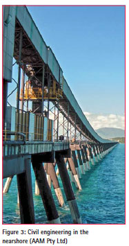
The role of hydrography in civil engineering
Hydrography in civil engineering introduces challenges of scale at the opposite end to the environmental role. Changes in shipping design, particularly propulsion systems, and in materials as well as in attitudes towards risk and risk mitigation mean that the standards currently required in civil engineering projects on land, particularly where there is the potential for harm to life or the environment, are increasingly expected and called for at sea.
Furthermore, improvements in acoustic and visualisation technology in hydrography offer savings in term of cost and time over traditional engineering measurement in the marine environment. It is now possible to visualise in 3D underwater using acoustic systems.
The role of hydrography in economic and social development
The Blue Economy has the potential to provide extraordinary resources. The expansion of mineral extraction offshore and of renewable energy are just two examples of the emerging importance of the Blue Economy where the relevance of hydrography is already established.
It is in the nearshore region however that the importance is most pronounced and probably least appreciated.
The nearshore region represents the area where all of these factors, including shipping patterns and leisure activities, combine to produce the most pressure on resources, particularly space. Whilst there are some temporal elements that reduce the squeeze in this area, such as tides and daylight, the limiting factor to using these areas optimally is the limitations of space, in all 3 dimensions.
A cost-benefit analysis – valuing infrastructure spend
Applying appraisal principles to hydrographic projects in support of energy, transport, flood risk and coastal erosion and communications.
Situation – there is demand for a new anchorage and landing point for cruise passengers in the SW Pacific islands.Currently a major cruise operator visits the island as part of their cruise cycle, visiting the island around every few days and staying for a day in the main town, which is served by a harbour with a jetty big enough for a cruise liner.
The cruise operator has identified a bay that they would like to use to land their passengers. The purpose is to provide the passengers with access to a picturesque bay with a beach so that the cruise experience is advanced. The cruise ship needs to be able to anchor, lower her boats and take passengers to the beach. A jetty would be beneficial.
Like much of the island, the bay is poorly surveyed and, although the cruise ship has entered and exited the bay safely in the past, the safety of such activities would be enhanced by a survey of the bay.
Social, economic and environmental considerations –
the potential of a survey in the bay goes beyond the one dimensional view given above. There is more to hydrography than just a navigational chart.
a. Measurement, regulation and control of environmental impact – benthic mapping, modelling, pollution monitoring, disaster mitigation, pollution control
b. Spin-off industries / activities – aquaculture, non-cruise tourism, diving
c. Secondary anchorage
d. Traffic and demand management
e. Climate change impact mitigation
f. Regulatory compliance
The requirement is to get all stakeholders involved so that the benefit can be fully articulated.
A mechanism for assessing and presenting the value of nearshore hydrography
a. Consider existing data sources – charted depths, echo sounder information from visiting ships, local knowledge, crowdsourced data, tidal data
b. Consider current shipping traffic patterns
c. Consider forecast shipping traffic patterns – without the survey / with the survey
d. Consider contribution of survey to other infrastructure projects
e. Consider contribution of survey to environmental projects
f. Consider contribution of survey to regulatory responsibilities
g. Consider contribution of survey to other industries
The decision to plan and undertake the survey should not be done in isolation nor should it focus exclusively on the needs of shipping. As many stakeholders as possible should be involved so that the full requirement and the benefits are identified and articulated. It may even be possible to identify additional sources of funding for the survey. These stakeholders may include:
• Local planning authorities
• Tourism
• Aquaculture
• Environmental agencies
• Nearshore resource extraction
• Pipeline and cable routes
• Local fishermen
• Port operators
• Defence and security authorities, and
• the Leisure industry, as well as the national charting authority.
Hydrographic surveys should be considered as part of the infrastructure of a country and should be thought of in terms that include the wider impact of traditional infrastructure, the interdependence of infrastructure networks, and the risk of infrastructure failure.
Options
Do nothing – There will be no initial investments costs but costs in other areas (eg the main port) may rise as usage increases, causing congestion in the port, and also the existing road / port infrastructure. Ships will only visit on an ad hoc basis meaning the local economy misses out on potential increased revenue from tourism. The cruise operators may decide to go elsewhere.
Do minimum – Use existing data to establish a safe entry and exit. A low cost option which may meet existing low demand. Possibility of congestion as the available space and facilities are limited.
Limited survey – approaches, anchorage and boat lane survey. There will be some reduction in navigation risk and the possibility that more ships will visit the bay. Navigable water will only be confirmed in those areas where the survey has been carried out. Costs will be quite high and the needs of only one sector will have been met. The fundamental capacity constraints will remain.
Full MBES survey – The investment cost will be very high but the whole of the bay will be mapped to a very high standard allowing safe navigation and optimising the use of space for multiple applications. This sort of investment should fit into a wider affordability strategy for all infrastructure development in the region and cannot be considered in isolation. It is very unlikely that nautical charting alone will justify this level of expenditure and the quality of the survey data is likely to be in excess of that required by non-nautical charting applications.
Multi-sensor survey – The various stakeholders are likely to have different requirements in terms of accuracies and coverage; nautical charting will require IHO Order 1a or Special Order accuracies which will drive the requirement towards a multibeam survey. This level of accuracy is unlikely to be required by fishermen and leisure users however and their needs may well be met by bathy LiDAR or lines of singlebeam data. The needs of aquaculture, benthic mapping, climate change and pollution assessment/ mitigation and regulatory requirements may even be met by satellite observations. Although these methods aren’t capable of the accuracies and object detection of MBES, and will not work at all in some conditions, they are much cheaper than MBES and produce data more quickly over a wider area. Approaching the survey of the bay in this fashion will have a lower initial investment cost than the MBES survey and yet the same benefits from the perspective of the stakeholders will be realised. Concentrating high effort into the areas where it is most needed, whilst also providing data at the appropriate level of detail across the whole of the bay offers the potential to meet multiple requirements, serve the needs of several applications and provide a more balanced cost-benefit ratio.
Valuing the risk of infrastructure failure
Societies and economies are dependent upon their infrastructure to provide the mechanisms that keep industries working, societies interacting and countries developing, whether it be the simple process of individuals getting to work, food getting to market or capital projects providing impetus to growth and job creation. For island communities and for economies with a maritime component the infrastructure extends well offshore and the failure to provide a safe and reliable offshore infrastructure can result in disruption and loss of output as a failure of terrestrial based infrastructure. In order to properly assess the benefits that can be derived from a hydrographic survey it is also necessary to consider the risks implicit in not conducting the survey.
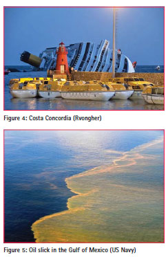
In order to assess the impact of not providing adequate hydrographic data it is necessary to consider the severity of an event, the probability of it occurring and the impact of the event on the society or economy. If a ship has an incident and blocks the approach channel to the main port it will have a serious impact on the functioning of that port as other traffic may be prevented from entering or leaving harbour. It may take some time to clear an obstruction eg. Costa Concordia, during which time the port is effectively closed to major traffic.
A fuel spill may cause damage to nearby marine ecosystems which will in turn affect the industries that are based on them eg. the Deepwater Horizon incident in 2010 in the Gulf of Mexico, and this may have significant implications for the parent company or the related industry, as with BP and oil production in the Gulf of Mexico.
In cost-benefit terms the risk associated with the infrastructure failure is measured by looking at the impact of these sorts of incidents and the probability of them happening as a result of that failure. In this case, the survey provides additional resilience into the infrastructure system that can be assessed by considering to what extent the probability of the incident occurring is reduced, how the additional information derived from the survey may mitigate the failure should it occur, and by how the impact of such an event may be reduced by the survey either directly or indirectly.
Placing a value on some of these things is very difficult and the value may vary from place to place and even time to time because the value will depend on the economic and social weight/importance placed by the society on the assets that could be put at risk. The effects of climate change provide a good example of this, where a rise in sea level in one place may mean only the need to build a higher sea wall, while in another the same increase in mean sea level could submerge a whole island-based society.
Assessing the benefits of hydrography
A more complete understanding of the nearshore environment can bring a number of benefits to be considered. The most obvious one is that based in traditional nautical charting which can improve safe navigation for ships and, when combined with good navigation skills and equipment, and sound seamanship, will reduce the risk of groundings and collisions occurring. Unfortunately it is not possible to prevent incidents happening for other reasons such as mechanical failure, weather impacts or human error. However, once an incident has occurred a good knowledge of the hydrography in an area can mitigate the impact of an event in the following ways:
• Assisting the safe conduct of a rescue effort
• Containing related pollution
• Enabling a recovery
• Permitting traffic management (diversion)
• Predicting the most probable short term and long term impact on the ecosystem
All of which will assist with the management and mitigation of the event and its aftermath. Good decision making is based on good and reliable information, especially in a crisis, and the provision of geospatial data is integral to the provision of good information.
A multi-sensor approach
One of the common issues with value for money is over-specifying the requirement. In an attempt to gather high specification data, a standard is set requiring an MBES survey for a shipping channel. A requirement could be density and accuracy allowing delineation of contours at 1m intervals. This is logical until the area reaches depths of less than, say, 10m. At this point requirement exceeds reality, as many ships won’t go there (unless there is plenty of tide). Effort and budget is expended chasing an unrequired standard and looking at only one aspect of hydrography or assuming that the job is best done by only one system type.
The GEBCO system (General Bathymetric Chart of the Oceans – www.gebco.net) is the origin of a Global Base Layer. It represents a basic level of information but is a significant step up from no data at all. Its limitations are known, however it forms the first stage of spatial decision making. GEBCO is also the original concept of crowd sourcing and yet technology, particularly in terms of data logging and position fixing, has made huge advances and suitable quality controlled crowd sourced data has the potential to contribute in a very big way to filling in the white space on charts. In the case presented here, the cruise ships that have already been in and out of the bay will have echosounder readings and position information that could contribute significantly to navigation safety at virtually no cost.
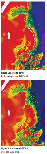
Satellite derived bathymetry currently has the ability to provide good quality depth data in very shallow and optically clear water. The uncertainty associated with the technology and the apparent errors in deeper water mean that its application is currently limited but it is a very cost effective method of obtaining depths in very shallow water in specific conditions. When combined with other data in the same area such as crowd sourced bathymetry or bathymetric LiDAR, the depths derived from satellite observations can be tuned to give a more complete and accurate picture of the sea floor.
The potential of satellite data is growing and improving. Although currently limited in depth and with uncertainties that exceed IHO order 1, it is a useful planning and risk reduction tool. Satellite data gathering is passive, repeatable and relatively cheap and will meet the requirements for environmental applications and most low level modelling requirements in very shallow water.
Satellite data can also identify areas where LiDAR bathymetry can ‘tighten’ the solution or provide Order 1 if required. This adds redundancy to the data as some areas will now be covered using independent systems, reducing the measurement uncertainties in these more important areas.
Bathymetric LiDAR is generally limited to depths of less than 50m (more commonly 20-30m) but achieves IHO Order 1, offering an economic alternative to MBES, particularly in shallow water where echo sounding may be inefficient or dangerous. Many modelling processes are better suited to lower resolution datasets.
LiDAR offers an IHO Order 1 compliant product in coastal areas at a price around half that of an MBES survey and will meet the needs of most applications outside high definition navigation surveys. It is ideal for the shallow waters of the bay considered in our study and can also inform the areas suitable for the shipping channel, anchorage area and approaches to be surveyed with mutibeam.
With Order 1 requirements met using LiDAR, and the very shallow and land area covered with satellite, MBES can be employed where it is actually needed. It is relatively slow and expensive in shallow water, which is a good reason to employ it only in those locations where it is really needed.
Valuing the wider benefits of hydrography
As with most infrastructure spending and investment, the benefits of hydrography extend into social and environmental effects which are difficult to measure and evaluate. For example, better charted information may mean that a ship does not have to have all her engines available for rapid manoeuvre which implies reduced CO2 emissions, improved air quality, less noise pollution and less wear on the ships machinery. Ships’ boats landing passengers in the bay may also have a positive effect on economic activity in the area itself, facilitating the creation of new jobs and spreading the benefits of the cruise industry further across the island.
It also represents increased resilience in the infrastructure. A safe anchorage and landing point would permit multiple ship visits to the island without increasing congestion in the port, and offers an alternative visit location should the port be rendered temporarily unsuitable by weather or other incident. The survey in the bay represents an extension of the existing infrastructure network and assets and is likely to have an impact on the rest of the network, perhaps in terms of more traffic throughout the network.
Infrastructure development is recognised as being a major driver of both commercial and residential economic development and investment in the infrastructure in the nearshore should be considered in the same way. Planning strategically, involving multiple stakeholders and applying the appropriate technologies, creates an opportunity to add significant value in a particular location when infrastructure is considered as part of wider development.
Conclusion
At the coastal margin, depths become critical for navigation, the environmental impact of humans is significant and the effects of onshore and offshore processes need to be fully understood. The coastal margin is where routine human activity is most influenced by, and affects, the hydrography. Geospatial data in the nearshore region provides information that underpins development and contributes directly to the infrastructure of the area both offshore and on land.
The importance of considering the coastal region as a whole is growing and it is no longer efficient to consider hydrographic surveys as a single dimension activity in support of safe navigation. In order to fully appreciate the benefits and costs of hydrographic surveys, they have to be considered as an integral part of the strategic planning process for infrastructure development and spending. Only then can the real contribution of hydrography be assessed and the right investment decisions reached.
A multi-sensor approach to surveys, blending data from different sources and at the appropriate levels of accuracy and cost, makes it possible to model the coastal margin more completely and to meet the needs of different users in specific areas; regional satellite mapping; project aerial survey; targeted acoustic survey. This approach offers real cost and time savings and allows a cost benefit analysis to be carried out that is appropriate to the needs of the multiple end users. It is a vast improvement over no data, historic data unlikely to be improved upon due to available budgets, or the prohibitive costs of trying to do everything with MBES.
Bibliography
Greenland A, 2013, Hydrographic Risk Assessment for maritime Safety, A presentation at the FIG SIDS Symposium 2013, Land Information New Zealand (LINZ), http://www.fig.net/pub/fiji/ ppt/ts1b/ts1b_Greenland.pdf
HM Treasury, 2011, Valuing infrastructure spend, Supplementary guidance to the Green Book, www. hm-treasury.gov.uk, London
International Federation of Surveyors (FIG), 2011, Report on the Economic Benefits of Hydrography, FIG Publication No 57, International Federation of Surveyors (FIG), Copenhagen
International Federation of Surveyors (FIG), 2006, Administering Marine Spaces: International issues, FIG Publication No 36, International Federation of Surveyors (FIG), Copenhagen
International Hydrographic Organisation (IHO), 2008, IHO Standards for Hydrographic Surveys, Special Publication No 44, Monaco, International Hydrographic Bureaux
Patreiko D & Holthus P, 2013, The Shipping Industry and Marine Spatial planning; a Professional Approach, the Nautical Institute, London http:// www.nautinst.org/en/forums/msp/
Quadros N, 2013, Bathymetry Acquisition – Technologies and Strategies. Investigating shallow water bathymetry acquisition technologies, survey considerations and strategies, Prepared for the Commonwealth Government of Australia DCCEE, Cooperative Research Centre for Spatial Information (CRCSI)
Waddington A, 2013, A Layered Approach, Hydro International, Issue 7 October 2013, p20-23, Geomares Publishing, Lemmer
All im ages were provided by AAM Pty Ltd or are in the public domain. The paper was presented at FIG Congress 2014, Kuala Lumpur, Malaysia 16-21 June 2014


 (No Ratings Yet)


Leave your response!