| Applications | |
Analyzing the cultural landscape – Preservation and development strategies
The article deals with the issue starting from a specific case, the identification and study of archaeological evidence around the Castle of Petriolo (Siena, Italy) for the protection, intervention and enhancement of this site |
 |
|
The contribution that is presented aims to highlight the methodologies and tools that can lead to a full knowledge of multi-layered cultural areas or landscapes by the actions and human interventions that have changed their perception over the centuries. The use of appropriate cartographies, the archival materials and documents and the selection of the most appropriate data management and processing methodologies are crucial for the structuring of investigations in complex territories, for their protection and enhancement. This is most evident for areas characterized by the archaeological features, elements and structures. For this reason, the article deals with this issue starting from a specific case, the identification and study of archaeological evidences around the Castle of Petriolo (Siena, Italy) for the protection, intervention and enhancement of this site.
The investigation area is located in Bagni di Petriolo, along the course of the Farma stream and near the confluence with the Merse stream, in today’s Municipality of Monticiano (Siena). The Farma valley delimits the current border between the provinces of Siena and Grosseto and is formed by the stream itself, which flows into the Merse stream, after collecting the waters of the Petriolo thermal springs. The Merse and Farma streams are part of the hydrographic system of the Ombrone river, one of the main connection routes between the backcountry and the Tyrrhenian coast since prehistoric times (Torelli M. 1992; Ascheri M., Borracelli M. 1997).
The examination of the archaeological evidences that characterize the site started with the collection of all the published information, materials and documents relating to the Petriolo area, including the two neighbouring valleys. The documentation was thus analysed and organized according to a chronological order to allow a first hypothesis regarding the evolution of the site and the related phases of anthropic activity. Such information was subsequently linked to all the data that emerged from historical, literary and iconographic sources (Massa S. 2017).
In parallel with the archival analysis, the cartographic materials available from 1800 to today have been collected and examined. These were obtained mainly from the Geoportale Nazionale and from Geoportale della Regione Toscana and include aerial photos, regional technical
maps (CTR), maps of the Istituto Geografico Militare (IGM), cadastral maps and topographical/morphological maps, historic and current and at different levels of detail. The materials that emerged from the archival and cartographic research, however, required a data management and a query system to provide a solid and complete reference framework for the subsequent evolutionary study phase and for the identification of the most critical portions from the historic, archaeological and landscape point of view.
This led to the creation of a Geographic Information System thanks to which spatial information could be georeferenced and thus identifying the different chronological phases in sequence. The materials have been structured on three distinct information levels, the first contains regional data concerning the morphology and orography of the area, urban centres, road infrastructures and regional regulations, the second reports information on the inter-provincial scale regarding mainly current and historic road infrastructure and provincial landscape plans. Finally, the third information level collects all the historic materials and current maps on a more detailed scale, so as to allow an in-depth analysis and to anchor all the data to specific points of the territory (Favino P. 2017).
The overlapping and comparison of the cartographic materials have made it possible to read some evolutionary transformations of the Castle of Petriolo and its main constructions and to identify the infrastructures formerly connected to the buildings. This operation also made use of the reconstruction of the morphological trend of the soil, the geomorphological characteristics and the documentation available in such a way as to highlight the areas of greatest interest from the historic-archaeological point of view (Bortolotto S. 2017).
On a methodological level, it was therefore preferred to obtain a database from historic, literary, archival, cartographic and iconographic sources, as complete as possible and included totally in a Geographic Information System, for easier consultation and analysis. From the study of these materials, the need was felt for a comparison with the current situation of the places to verify above all the first obtained results and, at the same time, to identify any signs or remains of archaeological or architectural nature, not reported in the archive documentation. In addition, the available cartographies, mostly on a scale of 1: 10,000 if not higher, represent the area and its anthropic components with a detail that did not allow immediate feedbacks and a certain positioning of the elements. Even looking at the aerial photos, past and recent, it was not possible to accurately distinguish the signs inside and outside the walls that delimited the Castle due to the definition of the aerial images and, especially, for the presence of a dense and high vegetation, the main reason that prompted us to plan a detailed on-site investigation.
The survey used a method based on Navigation Satellite Time and Ranging Global Positioning System technology, the NAVSTAR GPS, more commonly and synthetically known with the acronym GPS (Global Positioning System). However, it would be more correct to say GNSS (Global Network Satellite System) as it includes all the satellite constellations currently in orbit and therefore visible from the instruments (American GPS system with 31 satellites, Russian GLONASS system with 23 satellites, European GALILEO system with 26 satellites and the Chinese BEIDOU system with 16 satellites). The principle of operation of satellite systems is based on distance measurements between satellites in orbit around the earth with a constant distance and points on the ground of unknown coordinates and therefore to be determined. All the systems that use Global Network Satellite System procedures, regardless of their degree of accuracy and complexity, calculate the position of the receiver based on the position and time values sent by the available satellites. These are called ephemerides, that is the set of parameters necessary and sufficient to calculate the position of the satellite over time and then obtaining the position on the ground. This setting occurs only and exclusively if the instrument on the ground is able to capture the signal of some satellites, thus processing the data, through triangulations and semi-automatic corrections, to provide a planimetric and altimetric location of the points of interest (Bertocci S., Bini M. 2012; Guzzetti 2017).
Coming back to the case study, the area, located in the lower part of the valley of the Farma stream, is characterized by dense vegetation, both weed and tall, and by the remains of the elevated external walls of the Castle. This specific morphological conformation of the territory and the presence of high covering elements considerably reduced the portion of the sky visible from the ground and therefore also the possibility of acquiring the signals of the satellites in orbit. Theoretically, to obtain the coordinates of a point on the ground, it is necessary to record the signal of at least 4 satellites, however it would be preferable to increase this threshold to make the determination of the data redundant thus allowing greater precision in the spatial location of the elements to be analysed.
Considering these premises and in the impossibility of conducting a more advanced survey (Garzulino A. 2019), as too expensive in terms of time and costs, we have chosen to use a differential satellite system (DGPS), which allows to significantly increase the accuracy of the investigations compared to the traditional global consumer category tracking systems, such as road satellite navigators, smartphones, position detectors integrated with cameras, etc. This instrumentation (GNSS RTK Topcon Hiper PRO) consists of a base (Base Station) and a receiver (Rover Station) that operate in kinematic mode, fully integrated and connected to each other via Bluetooth technology. Specifically, considered the particular morphology and to deal with signal alteration problems due to the location and dimensional characteristics of the elements, it was decided to place the main unit (Base Station) in the only area free from vegetation and shielding elements, near the small church located close to the road that runs along the Farma stream. Here it was in fact possible to fix, with good quality, the constant signal of about 8 satellites and then proceeding with the synchronization and setting of the Rover Station to start the survey operations. Considering the environmental conditions, the period value, i.e. the time interval between two successive measurements, has been set equal to 5 seconds. Once the quantity and quality of the satellite signals picked up by the mobile receiver had been verified, it was possible to continue with the inspection of the area under investigation and with the recording of the planimetric and altimetric coordinates of each single point. By operating in continuous kinematic mode and being the receiver equipped with the OTF (On The Fly) option, it was possible to perform the entire detection campaign quickly and keeping the positioning error limited, ± 2 cm for the planimetric coordinates and ± 4 cm for the altimetries, despite the environmental difficulties encountered. Considered these critical issues, if consumer category units or less complex GPS instruments had been used a dilution of precision would have occurred mainly due to the acquisition of signals from satellites arranged in a nonprofitable way for the calculation of the coordinates. Unlike these devices, the GNSS RTK has assessed the conditions for selecting the satellites fully automatically, consequently reducing positioning inaccuracies to a minimum level.
The collected data was stored thanks to the use of a mobile device connected via Bluetooth to the Rover Station and capable of showing the planimetric and altimetric coordinates directly on the screen as well as the qualitative and quantitative information of the satellite signals.
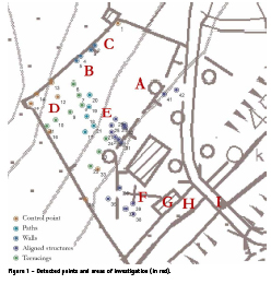
The information acquired was entered in the GIS environment and divided into categories based on the type of object detected: verification points, paths, walls, aligned structures, terracing (Figure 1). All the positions identified were checked once entered in the Geographic Information System and processed graphically with different colours to facilitate the identification of any connections with the archaeological and cartographic analysis previously carried out. The reconstruction of the ground trend, the geomorphological characteristics of the area and the study of the available documentation have therefore made it possible to develop a surface investigation strategy aimed at identifying the areas of greatest interest for the future definition of an archaeological risk map. The quantity and the layout of the buildings documented by archival sources, especially in the XV century, led to a detailed survey of the area delimited by the fortified walls of the Castle and in the area outside the North- Eastern/South-Western wall. On the other hand, specific surveys were carried out in areas of interest identified following the analysis of published cartographic and bibliographic data, external to the site. The systematic survey of the spaces has led to the detection of artificially regulated areas and of numerous remains of stone structures surfacing on the terrain and in exposed sections of the slopes, while the total absence of mobile finds on the surface was noticed. The collection and analysis of cartographic and
archaeological data have thus highlighted the presence of part of the built context of the village and of the remains of the walls pertinent to the building physically linked to the central internal section of the Northern wall of the fortification. In addition, the evidences in archival sources have provided tangible evidence regarding the organization of the settlement, the functions and often also the properties of the buildings. The acknowledgment of this information made it possible to obtain a relatively clear picture of the structure of the complex and therefore to plan subsequent investigations (Massa S. 2017).
Starting from this base, further investigation phases have been planned to allow the progress of the research and to proceed with the identification of the archaeological analysis. The phases indicated and preparatory to future interventions will concern first of all the cleaning of the weed vegetation in order to investigate archaeologically the internal sector of the walls in front of the Northern and Eastern wall (Figure 1 – A). After cleaning with archaeological assistance, stratigraphic surveys can be carried out in the area in front of the Western corner tower above the terraces (Figure 1 – B and D) and between the two wall partitions linked to the Northern wall (Figure 1 – C). A further area to be explored from an archaeological point of view is the central sector of the fortified area, which has numerous walls, some also contiguous and coeval, to be analysed in order to better understand the planimetric configuration of the village (Figure 1 – E). Regarding the area of the Church, a stratigraphic survey was planned to verify the grounds and the progress of the fortification wall to the East (Figure 1 – H) and West (Figure 1 – F) of the religious building together with an elevated stratigraphic analysis. Outside the building itself, it is advisable to check the possible presence of the ‘women’s bathroom’, of any pre-existing structures and perhaps a landing place (Figure 1 – G) under the current terracotta floor. It will also be interesting to investigate the stratigraphy of the tanks to verify their chronology. On the outside, a stratigraphic survey could be set on the remains of the structures of the oldest bridge, of which the ancient pillars of the ruined structure are still visible today (Figure 1 – I).
These analyses will give back a greater understanding of the place as a complex cultural resource and will allow a conscious enhancement of the site as an archaeological and environmental park and museum of itself.
Bibliography
Ascheri M., Borracelli M. (1997), Monticiano e il suo territorio, Cantagalli, Siena, Italy.
Bertocci S., Bini M., (edited by – 2012), Manuale di rilievo architettonico e urbano, Novara, Italy, pp. 162-167.
Bortolotto S. (2017), “Lettura delle cartografie storiche: permanenze” in A. Paolella (edited by), Bagni di Petriolo: Restauro e Valorizzazione, Edifir Edizioni Firenze, Pisa, Italy, pp. 159-174.
Cambi F., Terrenato N. (1994), Introduzione all’archeologia dei paesaggi, Carocci, Roma, Italy.
Favino P. (2017), “Sistema informativo geografico del sito di Petriolo” in A. Paolella (edited by), Bagni di Petriolo: Restauro e Valorizzazione, Edifir Edizioni Firenze, Pisa, Italy, pp. 149-158.
Francovich R. (2006), “Un parco senza confini. I segni della storia nel bacino del Farma-Merse”, in Detti T. (edited by), La terra dei musei. Paesaggio, arte storia del territorio senese, Giunti editore, Firenze, Italy, pp. 254-261.
Garzulino A. (2019) “LiDAR, territory and archaeological areas: new results and perspectives for the knowledge, analysis and preservation of complex context” in ISPRS International Archives of Photogrammetry, Remote Sensing and Spatial Information Sciences, Vol. XLII-2/W11, Copernicus Publ., Göttingen, pp. 549-555.
Garzulino A., Perego A., Zerboni A. (2014), “Mura Tarquiniesi: lettura delle evidenze (LiDAR) e degli aspetti geoarcheologici”, in Bartoloni G., Michetti L. M. (edited by), Atti del Convegno Internazionale PRIN: Mura di legno, mura di terra, mura di pietra: fortificazioni nel Mediterraneo antico (Sapienza Università di Roma, 7– 9 may 2012), Roma, Italy, pp. 131-140.
Guzzetti F. (2017), “I metodi satellitari”, in Campanella C. (edited by), Il rilievo degli edifici. Metodologie e tecniche per il progetto di intervento, Palermo, Italy, pp. 110-113.
Massa S. (2017), “Analisi dei dati archeologici noti e metodologia delle nuove ricerche” in A. Paolella (edited by), Bagni di Petriolo: Restauro e Valorizzazione, Edifir Edizioni Firenze, Pisa, Italy, pp. 131-148.
Scazzosi L. (edited by – 2002), Leggere il paesaggio. Confronti internazionali, Gangemi, Roma, Italy.
Torelli M. (1992), Atlante dei siti archeologici della Toscana, L’Erma di Bretschneider, Roma, Italy.


 (2 votes, average: 3.00 out of 5)


Leave your response!