| Applications | |
GNSS support to Canine search and rescue
|
||||||||||||||||||
| Earthquakes, landslides, avalanches, collapsed buildings… There are many situations in which people could suddenly become trapped and unable to free themselves without the assistance of search and rescue professionals.
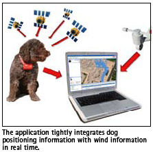
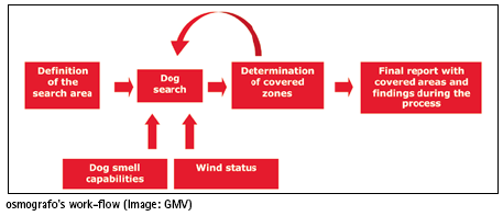
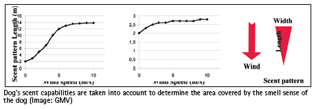
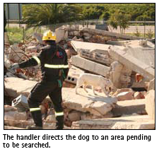
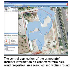
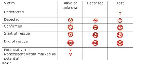
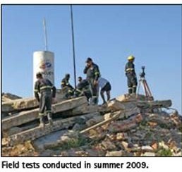
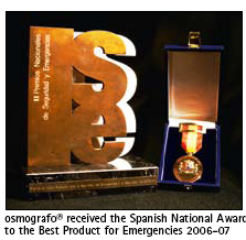
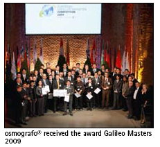
In response to those situations, and to help rescue teams locate and save people in need in the shortest possible time, the company GMV has patented and developed the osmografo®, GNSS-based support system for rescue operations that uses canine (K9) search teams. It seamlessly integrates dog positioning data with environment data such as wind direction and speed to determine areas covered by the dog’s smell. The system reads the dog’s positioning information and integrates it with wind data to build a map of the scent covered area in real time as it happens. The system offers support for the operative needs and procedures of canine Search And Rescue (SAR) teams. K9 SAR and the role of the windCanine teams are used worldwide for rescue operations, for which the dogs receive rigorous training on locating victims. The dogs rely on their keen sense of smell in combination with their training in order to scout the devastated region and detect the telltale scent of a human being trapped amongst the wreckage. In the search and rescue process the wind is a key factor that can aid the dog by allowing it to cover large areas much more rapidly and efficiently. With a moderate wind of a few kilometres per hour, the olfactory range of the dog can grow to up to a few dozen meters. This allows the dog to cover the entire search zone in fewer passes. When the total number of victims is unknown then the responsibility for determining that an area has been completely covered falls to the rescue operation coordinator. This decision will initiate a change of search area or the use of heavy machinery to clear the debris. In both cases the consequences could be fatal if there are undetected survivors that remain within the area. This decision currently relies solely on the technologically unaided opinion of one person. To determine whether there are areas that remain unsearched, the coordinator has to remember all routes the teams have travelled and the direction and speed of the wind. This in practice requires spending more time in any one zone than should be necessary in order to ensure that the zone has been fully searched before moving on to look for other victims, for whom any delay could be fatal. GNS support to K9 SARIn response to this challenge, GMV has developed the osmografo®, an innovate system that assists the rescue coordinator in determining whether an area has been fully searched by the canine teams. The name of the product has been selected to stress its main functionality, namely to represent the smell (osme, οσμη after the Greek). The system consists of a GPS tracking device attached to the dog that sends its position to a central monitoring unit and includes meteorological sensors that measure the speed and direction of the wind. It can be calibrated during training sessions to map the dog’s olfactory range as a function of the existing wind parameters. During a rescue operation, the central monitoring unit of the osmografo® records the wind characteristics and routes taken by the dog and shows in real time the effective area that has been covered. It compiles all of the search information from every team and displays the total area covered by the rescue squad at any moment. This provides invaluable support to the rescue coordinator for determining what areas have been fully searched and what areas have yet to be covered. In addition to these basic functions, the system has the ability to support the training of the dogs, handlers and coordinators by analysing in detail their training sessions and helping them to improve their search techniques. System ComponentsThe main components of the system are: • A wireless wind sensor with GPS positioning capability • A computer running a software application • A wireless communication device connecting all components to the computer All components have been designed for easy packing, transport and deployment on the field. The collars are light enough for all dogs and are equipped with a breakaway buckle for the dog’s safety.This way the collar is automatically detached if caught in something. The system has been designed to work in collapsed areas with absence of any telecommunication infrastructure. All provided wireless communications is autonomous without need of external resources. The collar device and the anemometer device send data wirelessly over long ranges using ISM radio bands. No internet connection is needed for operation and everything is battery operated. Data is received in real time at the operator’s computer and visualized in an integrated way. This includes generation and addition of smelled areas as the dog’s trajectory is being done. Personalised smell characteristics are defined for each dog and maintained in a database by the application. The operation coordinator can define a target area of interest and have an overview of the zone coverage. It is then possible to determine unsearched regions and act accordingly by alerting the handlers or introduce additional dogs to finish the search. The system has been developed in close cooperation with K9 Non-governmental organisation (NGO) IAE (Intervención, Ayuda y Emergencias, Valencia, Spain) to capture user needs and provide field testing. Support for rescue teamsThe software has been tailored to support rescuer’s needs in a variety of ways. The application supports the usual points of interest but also introduces special markings devoted to victims. As part of the focus on operative requirements, each victim or point of interest has a location but also events associated with it. The list of predefined events includes those commonly used during a collapsed area search and rescue operation as shown in Table 1. The used symbols are inspired by FEMA US&R Recommended Marking System. Several dog trajectories, searched areas, victims and events can be added up for coverage analysis. Support has been added for hiding places, victims and other special events. The operation’s reports are automatically generated by the application for activity traceability and documentation. The report describes search operation aspects including: ·Target zone description · Aerial georeferenced photography, maps(if added) All relevant data is maintained in a database allowing for later use such as export, search, comparison, etc. In addition to operational activities, the system can be used for training, certification and research. During training, the user can be assisted in the process of learning to read wind and dog smell capability. The handler can compare its understanding of the coverage with the one actually achieved. It is also possible to train the feeling of coverage of the search area with different dogs. The storage of a database of activities, data and progress is an important factor for dogs and handlers evolution assessment. During certification, the system can be a technological aid to rigorously trace and check the performance of dogs and handlers. The technology has also been used to further explore the influence of environment in dog’s capabilities as well as research on human mistakes in estimation of coverage. History and AwardsThe system concept was first proposed in mid 2006, after email interaction between GMV engineers and volunteers from the NGO IAE; a few months later the feasibility tests were conducted in the training field of this organization. Early in 2007, the patent was filed by GMV, and the development project defined and started. The first operational prototypes were tested in field in summer 2009, and a few improvements were introduced after the tests. The official international presentation of the prototypes was done in September 2009. Currently, the commercial version of the product is in preparation. The technology has been awarded several prizes. It received the Spanish National Award for the Best Product for Emergencies 2006-07, the award for one of the best 100 ideas in 2009, given by the economic magazine Actualidad Económica, and the overall prize in the European Satellite Navigation Competition, Galileo Masters 2009. In this competition it also received the prize for the best application in the region of Madrid and the Special Topic Prize Support to life. Summaryosmografo® is an innovative technological aid for search and rescue teams using rescue dogs. It does not substitute but provides added value to expert rescuers in their operation and decision making process. The system is fit to user requirements, not just technical, but operationally. Particular fit to dog characteristics with a safe detachable collar of right size and weight. This product, 100% funded by GMV as an internal R&D project, provides unprecedented combination of GNSS positioning, wind measurement and dog smelling capabilities in a simple, yet powerful aid to SAR teams. Human judgement, animal senses and technological aids are used together for the support of human life. AcknowledgmentsGMV is in debt with the K9 SAR nongovernmental organization ONGD Intervención, Ayuda y Emergencias, (www.iae.org.es), for their invaluable support in the definition of the user needs and the test phase. |
||||||||||||||||||
|
||||||||||||||||||
|
||||||||||||||||||
|



 (No Ratings Yet)


Leave your response!