| Geodesy - New | |
Study on the teaching method innovation of space geodesy
Space geodesy is a complete set of theory and method which uses natural objects or artificial objects to accurately determine the position of the point to determine the earth’s shape, size, external gravitational field and their changes over time [1]. Space geodetic techniques are changing quickly as many countries enhance emphasis on space exploration as well as the development of space science, computer, electronic communication and other modern science. The developments of society and human life in all areas have been profoundly affected by the achievements of space geodesy. The principles, techniques and methods are systematically introduced in the course of space geodesy, which will help students to master relevant knowledge comprehensively and lay a solid foundation for the subsequent scientific research Technology status of space geodesyThe primary missions of space geodesy consist of establishing and maintaining the earth or celestial reference frame and determining the high precision of Earth’s gravity field [1]. The resolutions of these issues need to rely on the continuous development of space geodetic techniques.
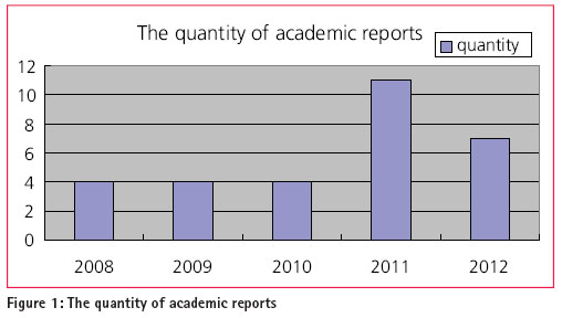
Very Long Baseline Interferometry (VLBI) VLBI measures the time differences r and its rate dr/dt in the arrival of microwave signals from extragalactic radio sources received at two or more radio observatories. Then, the baseline and the coordinate of the radio sources are determined. VLBI can be used to interconnect the Celestial coordinate system and the Earth coordinate system. Therefore, it can help us to determine the polar motion (Xp, Yp), th e earth-rotation variations UT1, the Precession and the Nutation parameters as well as providing scale reference for the ITRF. In order to break through the resolution limitations by the earth radius, the Space VLBI (SVLBI) has been studied and implemented. In addition, the Real-time VLBI represents the development trend of this technique. Global Navigation Satellite System (GNSS) On October 25, 2012, the successful launch of the 16th Beidou navigation satellite of China marks that the Compass can provide navigation service covering the Asia Pacific region. In addition, the GALILEO of Europe is under construction. And the GLONASS is gradually being restored by Russia. The modernization upgrade of the GPS has been implemented [2]. All of these make up the GNSS. The function of satellite positioning technology will be expanded in space geodesy, with the gradual development and improvement of the GNSS. Satellite gravity survey The first generation of satellite gravity technology takes advantage of the orbit perturbation of the satellite. Then, the satellite altimetry technology is used in the second. These have made great contributions to the establishment of the Ear th’s gravity field model and the refinement of quasi-geoid. The third generation of satellite gravity technology, which consists of the CHAMP, GRACE and GOCE, has being implemented. It greatly promotes the model’s resolution and precision of the Earth’s gravity field and the refinement of quasi-geoid. Satellite Laser Ranging (SLR) SLR has played an important role in determining the satellite orbit and orbital perturbation, as well as the establishment and maintenance of the ITRF. It will tap its huge potential in geodynamics along with the promotion of the observational accuracy, and the increase of the observation time and more reasonable of the station distribution. Satellite to Satellite Tracking (SST) There are two different patterns SST used– one is HL-SST which uses the highorbit satellite tracking low-orbit satellite, while the other uses the low-orbit satellite tracking low-orbit satellite. The former has been successfully employed to the inversion of gravity field of the earth by satellite CHAMP; moreover, it can also determine the satellite orbit. The GRACE uses the second pattern to achieve better precision of the earth’s gravity field. The teaching material contents and planThe teaching material keeps up with the latest technology and scientific research in the field of space geodesy. The basic concept, principle and technology are introduced to the students as much as possible in a way that is easy to be accepted. The teaching material consists of eight chapters. In the introduction, beginning with the limitation of the traditional geodetic techniques, the necessity and feasibility of the space geodesy is elaborated. Then, the basic concept, task and technology are introduced briefly [3]. Time and space are the basic dimensions used to describe the physical movement and change of objects. Therefore, the establishment, conversion and connection of the time references and position references are the primary research task for space geodesy. These contents are introduced in the second and third chapters. The theory and implementation of VLBI generally used in space exploration are introduced in the fourth chapter. Moreover, the high resolution and better precision are the strength of VLBI. The application and trends of this technology are given according to current scientific research. SLR can achieve centimeter to millimeter accuracy, which has played an important role in determining the satellite orbit and earth rotation variations precisely [3]. The new round of lunar exploration is planned and implemented, in which the Lunar Laser Ranging (LLR) will play an increasingly important role because of its high accuracy in determining the reference frame on the moon. These are the contents of the fifth chapter. Satellite altimetry and satellite gravimetry are successfully used in achieving high precision model of global gravity field and global geoid. The principle, data processing and development trend are introduced in the next two chapters. In addition, their increasing importance in oceanography, seismology and the global environment change and monitoring are also given. The development, present situation and upgradation of satellite navigation and positioning system are introduced in the last chapter. Moreover, the principle and data processing of pulsars navigation and positioning technology which have great potential in space exploration are introduced, too. The improvement of teaching method and effect analysisBased on the traditional teaching mode, the original teaching method mainly relies on depiction teaching, a certain amount of homework and discussions. This method needs further improvement in inspiring students’ interest and initiative. In order to keep up with the development of space geodesy, some improvements should be researched. Based on our experience in teaching and scientific research, some effective methods are introduced in the following, along with the teaching achievements. Participatory teaching method Participatory teaching method can fully take advantage of the initiative of teachers and students. It provides a communication platform which can be used in achieving thoughts and cognitive resonance [4]. Space geodesy is the forefront of geodesy, so it is difficult to master the knowledge because of its comprehensive content. Students can enhance the overall grasp of the course by making courseware, which can also help students to make full use of network to search the frontier. In addition, teachers can find some mistakes through the courseware. According to these, they can provide students with some advice. Moreover, the role reversal and discussions in class are also effective. For example, the quantity of international academic communication reports given by students in our research group within the past five years is presented in Figure 1. Figure 1 shows that the index has an apparent growth, which suggests that students’ creation and communication ability have been improved. Research-centered teaching Learning theory is aimed at application and research. Teachers should set up different research topics for each chapter according to the content of the course. Students should submit reports or papers after selective study. This method can not only help students to master knowledge profoundly, but also improve their comprehensive skills. Research-centered teaching can help students in learning. Moreover, it plays an important role in helping students to distinguish the trend and mainstream as well as scientific literacy training, which, therefore, is necessary to be adopted.
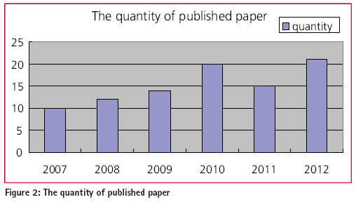
For example, the quantity of published paper given by students in our research group within the past six years is presented in Figure 2. Figure 2 shows that the quantity of published paper by students in our research group grows apparently, which suggests the effectivity of the Research-centered teaching method. Tracking the frontier An up-to-date state is one of the characteristics of space geodesy. All kinds of new theory, technology and research plans have been emerging with the development of science. Keeping abreast of new knowledge plays a definite role in grasping the teaching focus and research trend correctly. Students should be guided to browse websites (such as IERS, IVS, IGS etc) and periodical (such as Journal of Geodynamics, Planetary and Space science, Journal of Geodesy, Space Science Reviews etc) related to the subject. Some comments and advices should be given according to the report about the frontier submitted by students.
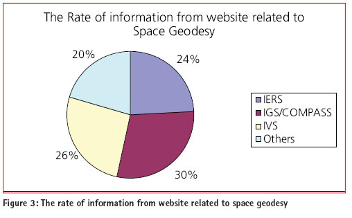
The statistics of the information from the websites related to space geodesy in our students’ papers are given in Figure 3. The combination of both the three charts suggests that it is helpful for students’ science research by tracking the frontier of space geodesy. The combination of subjects Space geodesy involves many subjects and technologies, such as space, computer, electronics and information technology etc. Therefore, making full use of achievements of all subjects is necessary and effective. For example, analysis of time series can play an important role in the analysis of Polar Motion. More conditions favorable to students to use this method should be created. ConclusionSpace geodesy is developing rapidly and the new space exploration movements are in the ascendant. All these indicate the bright prospects of Space Geodesy. Hoping all of these teaching method innovations from our research and teaching experiences can provide some good references. AcknowledgmentsThis research was funded by the national ‘863 Project’ of China (No. 2008AA12Z308), National Natural Science Foundation of China (No. 40974003) and the 2012 undergraduate comprehensive reform and teaching research project of School of Geodesy and Geomatics, Wuhan university (201220). References[1] Zhenghang LI, Erhu WEI, Zhengtao WANG et al. Space Geodesy [M], WUHAN: WUHAN UNIVERSITY PRESS, 2010. [2] WEI Erhu,CHANG Liu,LI Zhenghang On Course Construction of GPS Surveying and Data Processing[J]. Journal of Geomatics. Jun. 2012, 37(3) 44-46; [3] Erhu WEI, Qi ZHANG, Zhenghang LI, Fuhong WANG. On the Construction and Teaching Method of the Course of Space Geodesy[J]. Bulletin o f Surveying and Mapping, 2011(12) : 83-85; [4] Zhen Li. Study on Participatory Teaching Method[J]. Science Information, 2007(9):159 |


 (8 votes, average: 3.00 out of 5)


Leave your response!