| Navigation | |
Zheng He’s sailing to West Ocean
|
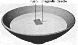
3.3 Nautical charts Figure 5. Zheng He’s Nautical Chart The charts utilize traditional Chinese landscape painting techniques to portray features such as mountains, islands, bridges, temples, and cities in detailed perspective. Figure 5 illustrates a portion of the chart. These graphic representations enabled the navigators to more easily identify important geographical features from shipboard. The charts include over 530 place names, including over thirty Asian and African countries and regions. Over fifty separate routes are delineated. Navigational data inscribed along the routes, such as compass headings and time notations. Zheng He’s nautical charts are of great both historical and practical value. These charts fully reflect the high level of navigational expertise of the time, and indicate that China’s maritime technology had essentially been perfected. It has been proposed that when Columbus, da Gama, Magellan and Cook later made the “discoveries’, they were carrying copies of the Chinese maps with then when they set off on their own journeys into the “unknown” (Menzies 2003). 3.4 Course and speed measuring Compass was the main means used by Zheng He in his epic ocean voyages. The compass was used to fix the direction and “geng” which recorded by Chinese era is used to measure distance. The compass used in the treasure ship was a kind of “wet compass”, that is a needle floating in water contained in a circular box with the compass points carved on wooden rim. On the compass there are 24 scales. Each scale, marked by different Chinese characters, represents a direction. The characters provided a way to mark the direction course route lines on the charts. The ship may follow one particular scale mark or follow a point between two scales. Figure 6. Magnetic compass Figure 6 shows the magnetic compass used by Zheng He’s fleet. The lower part of the figure is a replica of the compass and the upper shows the bearing correspondents of the Chinese character marks. Figure 7 shows a simple form of a “wet compass” (Xin Yuan-ou 2003). Figure 7. Simple form of “wet compass” Zheng He’s fleet used hourglass to measure the distances it covered. It was an instrument for measuring time by the trickling of sand through small opening from one glass bulb to another below it in fixed period of time, usually a “geng” (Information Office of Fujian Province 2005). “Geng” is a time recording unit, representing one of the five two-hour periods of a night, but here it refers to a unit of distance. Usually one “geng” was 60 li, about 30 kilometers. When taking the measure, they threw a wooden plank into the sea and then walked to the rear of the ship at a certain fixed speed to gauge the ship’s speed. Then route and distance were calculated and drawn on a map. That is what we see as the navigation chart, a precious material for studying Zheng He’s western ocean voyages. By using compass and the “geng”, navigators would know the position of the ship in the vast seas. 3.5 Organization The eunuch captains and admirals of these great treasure ships were men of awesome ability but, like the European explorers who followed them, they often drew their crews from the lowest levels of society. Most were criminals, sent to sea in lieu of imprisonment or internal exile, and in some respects life as a crewman was far better than a prison sentence. They were provided with a uniform – a knee-length white robe – food and wine, and were well cared for when at sea. The admiral’s staff included 180 medial officers, and every ship and company of soldiers had a medical officer for every 150 men. There was a varied and plentiful diet on the treasure ships, but the perils of voyaging through uncharted waters meant that life expectancy was short: only one in ten returned from the great voyages of exploration and discovery. But those who had survived the earlier voyages of the treasure fleets had been well rewarded. They were often freed and given endowments or pensions. Like all soldiers, the Chinese were superstitious. Each of Zheng He’s ships had a small cabin dedicated to Ma Tsu, the mariners’ deity, and prayers were said to her every evening before supper. When the crew went ashore in foreign lands, they carried round bronze mirrors to ward off evil spirits; on the reverse was the eight-spoked Taoist wheel. The elite of the crew were the navigators and compass-men, operating from an enclosed small bridge and living and dinning separately from the rest of the man. The junks also carried artisans and craftsmen of every description, capable of performing any task. Caulkers, sail-makers, anchor- and pump-repairers, scaffolders, carpenters and tung oil painters would keep the ships in good repair on their long voyage into the distant oceans. Tone-carvers and stonemasons were also embarked to leave permanent legacies of the fleets’ voyages across the world (Menzies 2003). |


 (7 votes, average: 3.43 out of 5)


