| Navigation | |
Zheng He’s sailing to West Ocean
|
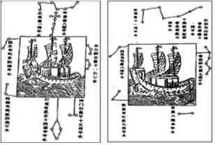
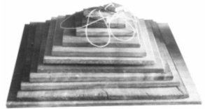
3.2 Celestial fixing Zheng He developed a whole set of navigation technology by looking at stars. Accompanying Zheng He’s nautical chart, there were four stellar diagrams. Figure 3 shows portions of two of them. Those diagrams passed on by Zheng He have not only enabled us to recapture the stars observed by navigators but also revealed the secrets of ancient navigation. Zheng He was able to determine his latitude by measuring the height of Polaris to the north and Southern Cross to the south. Twelve star boards (Fig.4) were used depending on the different height of the stars. The size of the largest board is around 24 cm by 24 cm (12 fingers as it was termed at the time, using the size of human thumb) and the smallest, 2 cm by 2 cm (1 finger), with 2 cm difference in succession (Zhao 2005). By using the attached thread, around 60 cm in length, the observer was able to fix the distance from the eye to the board, thus fix the angle of observation of the board, about 1.9° per finger. When observing the celestial bodies, the observer aligned the star on the upper side of the board and the horizon to the lower side, and thus the height of the star was determined. According to different heights of the stars, different sized boards could be used. By using Zheng He’s method, the positioning error could be controlled within 4.5 nautical miles, which was far superior to the general level at that time (Zhao 2005). Figure 3. Portions of stellar diagrams Figure 4. Star boards Menzies (2003) describes quite clearly astro-navigation of the fleet. The fleet used Polaris in the northern hemisphere. But when they were in Indian Ocean, and altered course to the southwest, southern Africa. Polaris, the Chinese guiding star, would have sunk closer and closer to the horizon and become invisible at 3°40¢N, north of Mogadishu in Somalia. Until they found another guiding star in the southern hemisphere to fulfil the same purpose as Polaris in the north, they were sailing into the unknown. The Chinese needed a star in the southern hemisphere to replace Polaris in the northern, and in the event they selected two: Canopus for latitude and the Southern Cross for navigation, they would have to sail far into the icy waters of the Deep South to locate the stars. To use Canopus for latitude, the Chinese had to determine its precise position by sailing to a point directly underneath the star. The Southern Cross points to the South Pole, but unlike Polaris, it is not directly above the Pole. To be able to use the Southern Cross for accurate navigation, the Chinese also had to locate its position in the sky – its height and longitude. Once again, the only way to calculate the precise position of the Southern Cross was to sail to a position directly beneath it. Menzies believes that only when Canopus and the Southern Cross had been located could new lands in the southern hemisphere be accurately placed on charts. When they reached Mount Adams in the West Falklands, the Chinese cartographers were nearly underneath Canopus. They were taking such pains to fix their position so that they could calculate their precise latitude: 52°40¢S. By cross-referencing Canopus to Polaris they could establish Canopus’s height and then use that star to obtain their latitude anywhere in the southern oceans. |


 (7 votes, average: 3.43 out of 5)


