|
The paper outlines how satellite altimetry can be used as a method to fi ll the gaps in available mean sea level data in the Caribbean region. The technique is examined in its utility to effectively monitor and compute MSL, and subsequently derive sea level rise (SLR) rates for the Caribbean
|
|
 |
Dr Dexter Davis
|
Department of Geomatics,
|
Engineering and Land Management
|
Faculty of Engineering,
|
University of the West Indies
|
St. Augustine, Trinidad and Tobago
|
|
|
 |
Dr Michael Sutherland
|
Department of Geomatics
|
Engineering and Land Management
|
Faculty of Engineering University of the West Indies
|
St. Augustine, Trinidad and Tobago
|
|
|
 |
Sandesh Jaggan
|
Department of Geomatics
|
Engineering and Land Management
|
Faculty of Engineering University of the West Indies
|
St. Augustine, Trinidad and Tobago
|
|
|
 |
Demi Singh
|
Department of Geomatics
|
Engineering and Land Management
|
Faculty of Engineering University of the West Indies
|
St. Augustine, Trinidad and Tobago
|
|
Even in 1996 it was reported that over half of the world’s population lived within 60 km of the shoreline (Turner et al, 1996). This trend has continued with an increase in the population in question. Small Island Developing States (SIDS), such as those in the Caribbean, tend to have much of their population live along coasts. This fact makes them very vulnerable to the effects of climate change, such as sea level rise. It is therefore important for SIDS to take steps to ensure sustainable development, and to prepare to adapt to and mitigate any threat (such as sea level rise) which may be potentially be detrimental to their socioeconomic prosperity (IPCC, 2007a; 2007b).
Sea level monitoring, an excellent tool for determining and predicting changes and trends in the sea level, is typically based upon accurate and reliable and long term tide gauge observations (Church et al, 2001). Unfortunately, long term consistent tide gauge data for sea level monitoring has been lacking in the Caribbean. In this region, only a small number of these tide stations are operational, most of which are plagued by problems of sporadic distribution, faulty equipment, data gaps and discontinuous results and coverage over time periods too short to account for climatic variations. This state of affairs creates gaps in Mean Sea Level (MSL) data (Sutherland, Miller and Dare, 2008). If only data from this method of measurement is used, without taking into account its drawbacks, the resultant models would be seriously constrained in their utility for dependable future projections. Figure 1 shows a digital elevation model of the island of Bequia, St. Vincent and the Grenadines, which includes a projected sea level of 1.4 metres above the mean that apparently seriously compromises the airport. This model is a potentially valuable tool to assist in developing appropriate adaptation and mitigation strategies. The lack of consistent long term tide gauge measurement, however, detracts much from the models predictive capabilities, underscoring the points made in the previous paragraph.

Figure 1 – Digital Elevation Model of the Island of Bequia
The lack of tide gauges and long term tidal data in most of the Caribbean means that MSL is currently undefi ned at many locales, as in the case of Bequia, or benchmarks can no longer be verifi ed or updated. In this paper, a modernistic approach to sea level monitoring and MSL determination is presented, through the use of satellite altimetry. The potential of satellite altimetry is examined, within the context of the challenges of maintaining an effective tide gauge infrastructure.
Sea level and satellite altimetry
Satellite altimetry has developed into an established technology for measuring sea level. In contrast to the sparse network of coastal tide gauges, measurements of sea level from space by satellite altimetry provide near global and homogenous coverage of the world’s oceans. Altimetry, as shown in Figure 2, uses pulse-limited radar to measure the altitude of the satellite above the closest point of the sea surface R. Global precise tracking along with orbit dynamic calculations are used to determine the height of the satellite above the ellipsoid, H. The difference between these two measurements results in the sea surface height, h given as;
h = H – R
However, accurate estimates of R and H are not sufficient for oceanographic applications of altimeter range measurements. The sea surface height, h relative to the reference ellipsoid is the superposition of a number of geophysical effects. In addition to the dynamic effects of geostrophic ocean currents that are of primary interest for oceanographic applications, h is affected by undulations of the geoid, hg about the ellipsoidal approximation, tidal height variations, hr and the ocean surface response to atmospheric pressure loading, ha. These effects on the seasurface height must be modelled and removed from h in order to investigate the effects of geostrophic currents on the sea surface height field (Chelton et al., 2001). Thus the sea level is given as

Attaining the required sub-millimetre accuracy for sea level rise monitoring, is challenging and requires satellite orbit information, geophysical and environmental corrections and altimeter range measurements of the highest accuracy. It also requires continuous satellite operations over many years and careful control of biases (Church and Gregory, 2001).
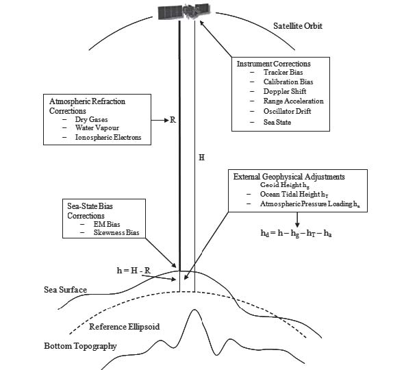
Figure 2 – Principle of Satellite Altimetry
Over the past 20 years satellite altimetry has provided a global, high resolution, consistent monitoring of sea level and ocean circulation. The launch of Topex/ Poseidon mission in 1992 was the advent of accurate altimetric based sea level data. With a repeat period of ten days, satellite measurements globally provided more details than in-situ tide gauge based observations over the last hundred years. Later in 1995, the European based ERS-2 satellite was launched followed by the Jason-1 in 2001, Envisat in 2002 and more recently Jason-2 in 2008. This multi-mission satellite period brought increasing data quality with the reprocessing of measurements, along with the continuity and homogeneity of data. At present the Envisat satellite with a 35 day cycle, Jason-1 and Jason-2 satellites with a 10 day cycle are in orbit providing very precise sea level data.
Sea level monitoring in the caribbean through satellite altimetry
The spatial and temporal distribution of satellite altimetric data, combined with the fact that it is a space-based measurement system means that it has the potential to address many of the problems that plague tide gauge installation, distribution and maintenance. It is therefore a particularly advantageous alternative to tide gauge measurements in regions like the Caribbean where these problems are characteristic to the challenge of effective sea level monitoring and consequently coastal zone management.
Several studies have been undertaken to show the applicability of the use of altimetric data as an alternative to tidegauge measurements (Madsen et al., 2007; Ginzburg, 2010 and Robinson, 2010). Jaggan and Davis (2012) describe a comparison of sea levels within the Caribbean between altimetric and tide gauge data. In the study, eight tide gauge sites in distributed in Puerto Rico and the Gulf of Mexico, as shown in Figure 3, were compared to interpolated satellite altimetry measurements for the period 2001 to 2010.
The results displayed an encouraging agreement between the tide gauge and altimetric data as shown in Figures 4 (a), (b) and (c), which depict the differences from three randomly selected sites of the eight investigated. Overall, the variations were generally of the order of 2cm in the mean and 5cm in the RMS between the tide gauge and satellite altimetry measurements.
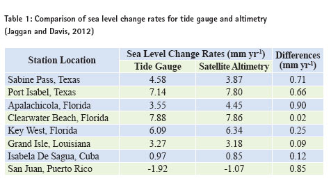
In the determination of sea level rise rates, a linear regression analysis was performed on the altimetric data with a summary of the results presented in Table 1. Taking into account the temporal and spatial differences between the measurement parameters; the altimetry being a 10-day discrete, open water measurement system vs. continuous coastal measurements for the tide gauges, the sub millimeter agreement for the sea level change demonstrates the applicability of the technology for sea level monitoring in the region.
Altimetry as a tool to determine mean sea level
Currently many Caribbean states lack an accurate and defi nitive reference of mean sea level due to the absence of long term functioning tide gauges. As a result, islands such as St. Vincent do not have a vertical reference system that can be easily maintained or verifi ed. Although the geoidal model, CARIB97, exists as a reference surface, the geoid does not equate to mean sea level as the latter is not an equipotential surface.
Sideris and Fotopoulos (2006) highlight a few approaches to determine a vertical reference system (MSL).
• Using a network of tide gauges, a free-network adjustment is done by holding one station fixed. A correction factor is applied to the adjusted heights so that the mean height of all tide gauges equals zero. However, this method relies heavily on measurements from a single tide gauge and ignores mean sea level (MSL) observations made at other stations.
• MSL can be measured by a network of reference tide gauges situated along the coastlines and fi xing the datum to zero at these stations. This can result in distorted heights since it ignores land motions and subsequent movements of tide gauges.
• Using the best model for the Sea Surface Topography (SST) at a network of tide gauge stations and then adjusting the network by holding MSL to zero for all tide gauges. SST models are not accurate near the coasts and can result in distortions for MSL.
• Using estimates of orthometric heights derived from ellipsoidal heights and precise gravimetric geoidal heights along a network of tide gauges. This relates the regional vertical datum to a global vertical reference surface (ellipsoid) and supports the realization of a World Height System.
Satellite altimetry has provided two decades of near global, continuous sea level data. However, while consistent and reliable data is available, altimetric data is based on the open ocean and its weakness lies in coastal measurements and monitoring. A vertical reference system must be localized as local factors infl uence its determination. Hence, satellite altimetry derived data alone is not sufficient to effectively and accurately determine mean sea level.
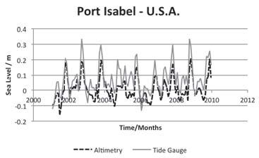
Figure 4 (a)- Sea level anomalies averaged over a month for Port Isabel 2001 – 2010 (Jaggan and Davis, 2012)
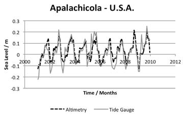
Figure 4 (b) – Sea level anomalies averaged over a month for Apalachicola 2001 – 2010 (Jaggan and Davis, 2012)
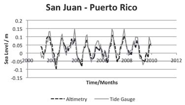
Figure 4 (c) – Sea level anomalies averaged over a month for San Juan 2001 – 2010 (Jaggan and Davis, 2012)
To compensate for the weaknesses of the altimetric measurements closer to land, a method using a combination of satellite altimetry and short term tide gauge sea level monitoring, is proposed in an attempt to address this problem in Bequia, St Vincent and the Grenadines. The realization of a vertical datum would necessitate the installation of a network of tide gauges collocated with GNSS receivers at strategic points along the coast of Bequia to record short term sea level data. The GNSS measurements will monitor and allow corrections for any vertical land movement taking place. Since tide gauges measure sea level relative to land, satellite altimetric based data will be used to tie the tide gauge data in an absolute reference frame. Studies by Dong et al. (2002) and Mitchum (1998 and 2000) have been successful in verifying and integrating satellite altimetry data with tide gauges. These studies provide the basis and methodology that will be used to integrate the different measurement techniques in order to determine a MSL reference datum.
With MSL established, appropriate scenario analysis can now take place applying the sea level rise rates determined through the satellite altimetry. Applying the sea level rise parameters to an incorrect vertical datum will clearly overestimate or underestimate any potential impacts and consequently affect any coastal zone planning policy mitigation strategies adopted.
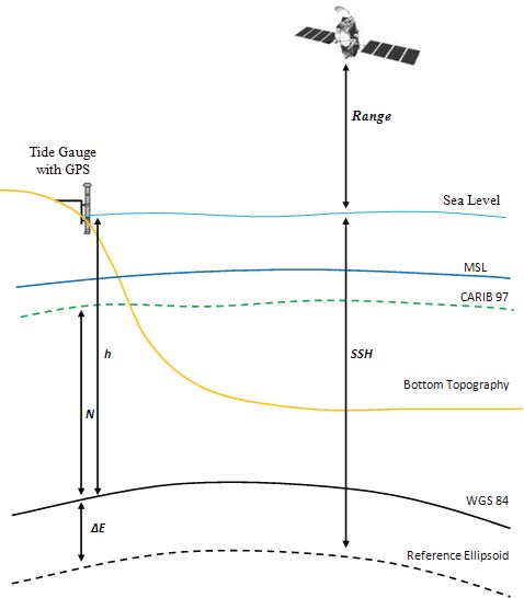
Figure 5 – Concept of MSL determination using Satellite Altimetry and Tide Gauges
Conclusion
The situation regarding the vertical datum establishment and monitoring in Bequia, St Vincent and the Grenadines is a representative of many of the states in the Caribbean. Considering the vulnerability of the region to changes in sea level, the defi nition of the vertical datum is a major concern. This critical issue however has largely been overlooked because of the diffi culty in establishing and maintaining adequate tide gauges as well as tide gauge records.
Satellite altimetry provides consistent accuracy, coverage, and independent space-based measurements in a geocentric reference frame, which are all necessary for the practical realization of a vertical datum. From the same altimetric datasets, there is the potential not only to obtain data to establish MSL, but also to monitor changes in sea levels. Currently, there is 20 years’ worth of altimetric data available, which would represent a long term data set for tide gauge records, adequate to establish MSL. Satellite altimetry gives an even spatial distribution free from issues of vandalism, theft or lack of proper maintenance that can account for the lack of tide gauges in the region. It therefore has the potential, once calibrated with tide gauge and GNSS data, to fulfil two of the major functions of the missing tide gauges in the region; establishing MSL and monitoring sea levels
References
Chelton, D. B., John C. Ries, Bruce J. Haines, Lee Lueng Fu and Philip S. Callahan. 2001. ”Satellite Altimetry”. In Satellite Altimetry and Earth Sciences A Handbook of Techniques and Applications. Edited by Fu, Lee-Lueng and Cazenave, Anny. Chap. 1. Academic Press, San Diego.
Church, J.A. and Gregory, J.M. 2001. Changes in Sea Level. IPCC Third Assessment Report. http:// www.grida.no/publications/other/ ipcc%5Ftar/?src=/climate/ipcc_tar/ wg1/408.htm. (Cited 02/03/2012)
Dong, X., Woodworth, P., Moore, P. and Bingley, R. 2002. ”Absolute Calibration of the TOPEX/POSEIDON Altimeters using UK Tide Gauges, GPS, and Precise, Local Geoid Differences”. In Marine Geodesy. Vol 25, pp. 189-204.
Jaggan, S. and Davis, D. 2012. ”Evaluating Satellite Altimetry for Monitoring Caribbean Sea Level Rise”. In The West Indian Journal of Engineering. Vol.35, No.1. In press.
Ginzburg, A.I., A.G. Kostianoy, N.A. Sheremet, and S.A. Lebedev. 2010. ”Introduction and assessment of improved coastal altimetry strategies: Case study over the northwestern Mediterranean Sea”. In Coastal Altimetry. edited by S. Vignudelli et al. chap. 14. Springer, New York.
Intergovernmental Panel on Climate Change (IPCC) (2007)a. Climate Change 2007: Synthesis Report. Based on a draft prepared by the Core Writing Team, adopted by IPCC
Plenary XXVII, Valencia, Spain November 12-17. Cambridge University Press, Cambridge UK, 7-22.
Intergovernmental Panel on Climate Change (IPCC) (2007)b. Climate Change 2007: Impacts, Adaptation and Vulnerability. Contribution of Working Group 11 to the Forth Assessment Report of the Intergovernmental Panel on Climate Change, M.L. Parry, O.F. Canziani, J.P. Palutikof, P.J. van der Linden and C.E. Hanson, EDS., Cambridge University Press Cam-bridge UK, 7-22.
Madsen, K. S., J. L. Hoyer, and C. C. Tscherning. 2007. ”Near-coastal satellite altimetry: Sea surface height variability in the North Sea–Baltic Sea area”. In Geophys. Res. Lett. Vol 34, L14601.
Mitchum, G.T. 1998. ”Monitoring the Stability of Satellite Altimeters with Tide Gauges”. In Journal of Atmospheric and Oceanic Technology. Vol 15, pp. 721-730.
Mitchum, G. T. 2000. ”An Improved Calibration of Satellite Altimetric Heights Using Tide Gauge Sea Levels with Adjustment for Land Motion.” In Marine Geodesy. Vol 23, No. 3, pp. 145.
Robinson, I. S. 2010. Discovering the ocean from space: the unique applications of satellite oceanography. Heidelberg; New York: Springer; Chichester, UK. 638 pp.
Sideris, M.G. and G. Fotopoulos. 2006. World Climate Research Program (WCRP) Workshop on Understanding Sea-level Rise and Variability. Paris, France, June 6-9, 2006.
Sutherland, M., P. Dare and K. Miller. 2008. ”Monitoring Sea Level Change in the Caribbean.” In Geomatica, Vol. 62, No. 4, p. 428-436.
Turner R.K., Subak S., and Adger W. N. 2006. Pressures, Trends and Impacts in Coastal Zones: Interactions Between Socioeconomic and Natural Systems. Environmental Management Vol. 20, No. 2, pp. 159-173. |


 (5.00 out of 5)


 (5.00 out of 5)


 (5.00 out of 5)


 (4.99 out of 5)
Leave your response!