| Policy | |
The Role of LIS in Instigating Development of a NSDI in Tanzania
This paper identifies and discusses the standards supportive of the proposed integrated LIS and highlights elements that can be agreed, standardized, and shared as part of the development of a national SDI |
 |
|
 |
|
Anation-wide Land Information System has the potential for providing the basis on which a National Spatial Data Infrastructure can be developed, given the strong similarities between the two concepts. In a country such as Tanzania where agriculture is the main sector of the economy, proper management and administration of land is of prime importance, and an LIS is an indispensable tool for effective and efficient land delivery services. Likewise, SDI must be developed to support the efforts to fulfill the vision of the nation. Among other issues, the Tanzania 2025 Vision places emphasis on transforming the current low productivity agricultural economy to one led by modernized and highly productive agricultural activities. The national SDI should support LIS to realize the nation’s vision. However, as is the case for many countries, LIS and SDI are developed through different independent projects. This poses problems of possible misalignment of LIS and SDI, a situation which can bring about conflicts and duplication of efforts (Siriba, and Farah, 2008).
Currently, there is no formal SDI in Tanzania. Nevertheless, most of the core elements of SDI exist. These have been developed over the years for use with legacy land information systems and have the potential for providing the foundation for a national SDI. These include:
(i) A vibrant land policy and an active institutional framework for land management and administration,
(ii) Application of technologies especially in ICT, such as improved access to internet brought about by a newly established opticfiber network that connects most districts in the country, and
(iii) Availability of fundamental spatial data such as- topographic maps, geodetic control network, and cadastral data.
The least developed element for both LIS and SDI relates to standards. Standards provide a framework for the development of any system (IT or otherwise) and represent codes of best practice. Using standards ensure interoperability between data elements of separate systems and greatly enhances the sustainability of systems, as it ensures a greater ease of transformation and portability in future development of both LIS and national SDI. The standards that will affect the integrated LIS include: Standards related to business processes and LIS professionals, e.g., land surveyors, land administrators or property valuation officers; standards relating to geographic information; standard for describing land information; standards relating to ICT; standards for storing and archiving documents, and standards for software development practices and methodologies. There is also a need for defining a number of national standards for the use of coordinate systems and projections, common transformation parameters between coordinate systems and formalize unique parcel identification numbering system.
Development of an integrated Land Information System in Tanzania
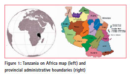
Tanzania is located on the east coast of Africa between latitude 1°S and 12°S, and 29°E and 41°E. It is bordered by Kenya and Uganda to the north, Rwanda, Burundi, and Democratic Republic of Congo to the west, Zambia to the southwest, Malawi, and Mozambique to the south, and the Indian Ocean to the east (Figure 1).
Tanzania mainland has an area of about 931,000 sq. km of which 886,000 sq. km is land, the rest is water. 23% of the land is allocated to r eserve areas such as national parks and forests. Only 5% of the land area is cultivated. The rest is pastureland. The i slands of Zanzibar have an area of 2,611 km2 (NBS, 2011). According to a 2012 census, Tanzania had a population of 45 million (NBS, 2012). In 1964, Tanganyika united with the isles of Zanzibar and became the United Republic of Tanzania. Zanzibar has its own cadastral system. Therefore, the land information described herein does not include the isles.
Tanzania’s economy depends heavily on agriculture, which accounts for about onethird of GDP, provides 85% of exports, and employs about 80% of the work force. Tourism is growing in importance and ranks as the second highest foreign exchange earner after agriculture. Mineral exploitation (gold, diamonds and tanzanite) has increased significantly in the last decade. Tourism is Tanzania’s biggest source of economic growth. It provides over 3% of the GDP, and accounts for half of Tanzania’s exports (CIA 2013). Agriculture being the main economic sector, proper management of land is critical for the nation’s sustainable economic development.
Major land reforms in Tanzania were introduced as a result of the Land Policy of 1995 and the subsequent land laws of 1999, namely Land Act No. 4 of 1999 (Cap 113) and Village Land Act No. 5 of 1999 (Cap 114). Other laws include Land Use Planning Act No. 6 of 2007, Urban Planning Act No. 8 of 2007, The Unit Titles Act, The Mortgage Financing Act, Survey Ordinance Under revision and Valuation Bill.
Prior to the Land Policy of 1995, bare land had no value in Tanzania. The value of land was determined on the basis of existing improvements (developments) made on the land such as buildings and crops. One of the most remarkable reforms in the Tanzanian land policy was the recognition that bare land has monetary value and that it can be transacted much like any asset.
The increased value for both land and land related properties as well as a fast growing population has tremendously increased demand for land. Also, land related transactions involving sale, transfer, and mortgage of land has increased (Derby, 2002). This increase has contributed to problems in operational processes and handling of different transactions in land, poor storage of land records and general inefficiency in delivering core land administrations functions.
Remarkable efforts to computerize land records as a way of improving land delivery services at the Ministry of Lands, Housing, and Human Settlement Development (MLHHSD) began in 2002. From 2002 to date, the following applications have been developed and are currently in operation;
(i) Land Rent Management System (LRMS) – This is an in-house developed application which assists in assessing, collecting, and keeping records related to land owners and respective land rent payment data. LRMS is a standalone system, and currently has been deployed to 40 out of 130 local authority land rent collection centers.
(ii) Surveys Registration System (SRS) – This was also developed in-house and is used to manage and speed up the entire process of submission, checking, approving, and registration of all cadastral surveys throughout the country. Checking, approval and registration of cadastral surveys is currently centralized at the Surveys and Mapping Division (SMD) of the MLHHSD.
(iii) Management of Land Information System (MOLIS) – This is a web-based land information system developed by a consultant. The system is being used for performing most of the land management functions at the MLHHSD, and the three municipal councils of Dar es Salaam city. LRMS has been integrated in MOLIS.
The above mentioned applications operate in isolation and some functions, which are essential to realize an electronic Land Information System, are still being carried out manually. A critical setback of the existing land information system is lack of a direct link with digital cadastral information. MOLIS operates only with alphanumeric data. All spatial information is handled and processed manually. This is a major hindrance to effective service delivery due to increased time spent on searching and processing manual cadastral information (paper-based maps). That is why, despite all the above mentioned efforts to computerize land delivery services, efficiency has not improved satisfactorily. At present, issuance of a title deed may take about six months compared to the previous period of one year. Still, this is seen as a very long period and Tanzania has a long way to go in terms of registering land and improving land information systems (Kironde 2009).
To address challenges of the land sector in its effort to provide better land management services to the public, the Tanzanian government has initiated a project to develop an Integrated Land Information System. ILIS is expected to address all functions of the land sector. It will provide tools for handling land management functions; namely town planning, cadastral surveying and land delivery services.
The ILIS development project is divided into two phases- design and implementation phases. The design phase started in July 2012. The implementation phase is expected to be completed after 18 months. The project is overseen by the Ministry of Land, Housing and Human Settlements Development (MLHHSD) responsible for land management and administration.
Spatial Data Infrastructure and Land Information System
Spatial data creation and use is increasingly becoming more popular in recent years. In simple terms data or an entity is spatial if it has shape and location, and thus can be represented by a symbol on the map. Based on this understanding of spatial data, it is evident that most of the data handled in information systems is spatial in nature. Humans live and work in certain places, all base maps, cadastral maps and so on, are intrinsically spatial information.
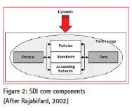
After societies realized the usefulness of attaching spatial attributes to business entities and creating thematic maps, the concept of spatial data infrastructure (SDI) was coined. It has been given a number of different definitions. One of them says SDI is an initiative intended to create an environment that will ensure that a wide variety of users who require coverage of a certain area will be able to access and retrieve a complete and consistent datasets in an easy and secure way (Rajabifard, 2002). According to another definition, SDI is “coordinated series of agreements on technology standards, institutional arrangements, and policies that enable the discovery and use of geospatial information by users and for purposes other than those it was created for” (Kuhn, 2005).
The main components of SDI can be categorized as people, policy, standards, access networks, and data. The nature and relationship between the components can be summarized as follows; people (data producers, value-adders and data users) can access and use spatial data by means of technology through well defined policies on standards and access networks. SDI core components have a dynamic nature due to the fact that technology which affects all the components changes from time to time. Likewise, people’s requirements on spatial data change with time as well as jurisdiction. See Rajabifard (2002) for a detailed treatment of SDI components. Figure 1 shows the general SDI model, including the SDI core components.
SDI can be created for smaller levels or jurisdictions, but usually it is thought to be a national level infrastructure and is comparable to other kinds of infrastructures like road or electricity networks. On the basis of the above considerations, following elements can be agreed, standardized, and shared as part of a national spatial data infrastructure for Tanzania:
(i) Spatial data (information), and the metadata cataloging and describing it
(ii) Tools and technical platforms for creating, editing, publishing, and sharing spatial data
(iii) Technology standards (including data and data exchange models)
(iv) Institutional arrangements (like agreement on spatial data providers)
(v) Land information policies
Challenges of National SDI development in Tanzania
Creating SDI is usually a government project. Examples are the National Spatial Data Infrastructure (NSDI) in United States, Canadian Geospatial Data Infrastructure (CGSDI), Australian Spatial Data Infrastructure (ASDI), and the European Commission INSPIRE initiative (Hall, 2003).
Efforts to develop a national SDI in Tanzania have not yet been successful. These efforts can be traced back to 2003, when a Steering Committee was set up in March 2003 to oversee the development of the proposed NSDI (Mtalo, 2003). The committee comprised volunteers who had the technical know-how but unfortunately had no resources at their disposal to make substantial progress. Apart from an SDI draft policy prepared in 2005, no further progress of the National SDI initiative has been reported to-date.
The challenges of NSDI development in Tanzania have been studied by Hagai (2010), Kalunde and Ondulo (2006), Johansson (2005) and to a great extent seem to be a result of limited knowledge and general lack of awareness on SDI. Other major factors reported include lack of a National SDI Policy, limited funds to sustain SDI; lack of institutional leadership to coordinate SDI development activities, and lack of political commitment. This is in agreement with other studies such as Clausen (2006), Nedovic et al (2004) which point out that awareness is a critical motivate for adoption and development of SDI.
The relationship between LIS and SDI
The importance of the relationship between LIS and SDI was underscored by the Bogor Declaration on Cadastre Reforms in 1996, which stated that the spatial cadastral framework usually a cadastral map – should be a fundamental layer within a national SDI (FIG, 1996). In Tanzania, the Ministry for Lands, Housing and Human Settlements Development (MLHHSD) is a key provider of spatial data and the integrated LIS will therefore be a basic pillar of SDI. Outcomes of ILMIS project can be utilized to build the basics of a national spatial data delivery platform and national SDI. Therefore ILMIS must implement the following basic SDI information system components:
(i) A spatial data repository
(ii) Application software for creating and updating data
(iii) Processing services like datum and projection transformations
(iv) A geo-portal for searching, browsing and querying metadata, services, and resources
(v) Internet services for publishing and delivering data
(vi) Application software for accessing and analyzing spatial data
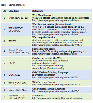
Spatial standards
Spatial data in ILIS must conform to a number of standards in the form of either ISO standards and/or OGC standards. Client and server components must be able to work with some or all of the standards listed in Table 1.
The most important spatial data standards, namely the Land Administration Model, Geodetic Reference Frame and Unique Parcel Identification System are discussed in the following paragraphs.
Land Administration Domain Model
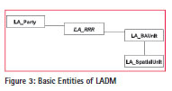
One of the most important international standards to be part of Tanzanian SDI is ISO 19152. Land Administration Domain Model (LADM) was approved recently in November 2012. It defines terminology for land administration and provides an abstract conceptual model (see Figure 3) with four packages;
1) Parties (people and organizations)
2) Basic Administrative Units (BAU), (condominium, farm lot, etc.)
3) Rights, Responsibilities and Restrictions (RRR)
4) Spatial Units (parcels and the legal space of buildings and utility networks), Spatial Sources (surveying) and spatial representations (geometry and topology).
LADM is a standard that describes spatial data and provides a technical model for storing spatial data, documents, and related property rights. Van Oosterom et al (2011) prove that the LADM is very versatile in adapting to different data needs. It is therefore highly recommended that ISO 19152 LADM should be adopted as one of the first standards in Tanzania national SDI.
Geodetic Reference Frame
Defining a Geodetic Reference Framework consists of defining ellipsoid, datum, projection, and coordinate system. Two common frameworks in Tanzania are the Local coordinate system and Universal Transverse Mercator (UTM). The local coordinate system includes different projections for each specified locality, usually an urban area, and frequently different projections for different areas within the country. If all official geographic measurements within a country are made in the same measurements framework, the resulting maps, georeferenced aerial photographs, and satellite images are compatible and can be layered on top of each other without any extra preprocessing and conversions.
Establishment of a new geodetic control network for Tanzania based on the international WGS 84 reference datum as part of the African Geodetic Reference Frame (AFREF) initiative started in 2006, and is expected to be completed in June 2013. The objective of the AFREF initiative is to unify and modernize the geodetic reference frame for Africa, and the national and regional reference networks. When fully implemented, it will consist of a network of permanent GNSS/ GPS stations whose generated data would be freely available to users anywhere in Africa (RCMRD, 2007). It is highly recommended that MLHHSD should declare this as the official coordinate systems and transformation parameters should be made available for conversion from old reference systems to the new coordinate systems and projection.
National Level Unique Parcel Identifier
Currently, there is no nationally adopted numbering system for parcels. In order to create a software system that handles parcels centrally and in order to ensure the uniqueness of each parcel, such a numbering system should be adopted and enforced in Tanzania. According to IAAO (2012), the desired characteristics of Unique Parcel Identification Number (UPIN) are;
Uniqueness, there must be an assured oneto- one relation between parcel and parcel identifier; Permanence, parcel identifiers should not be allowed to change once they have been assigned a parcel; Simplicity, parcel identifiers should be composed of as few digits as possible; Ease of use, it is preferable that parcel identifiers is human readable i.e., that one can infer location from the components of the identifier.
Despite many options and problems in each of the numbering types as elaborated in IAAO (2012), a standard for national parcel numbering should be like the standard geodetic reference frame that is defined and put in place before ILIS implementation.
Strategies towards a political win to national SDI development
Strategies to win political support for development of a national SDI in Tanzania are based on increasing awareness to policy and decision-makers not only on the benefits of SDI, but also on the costs or penalty that the government incurs as a result of not acting to address SDI issues. In the first approach, advocacy for SDI is based on explanation of both tangible and intangible benefits of SDI to the society using cost-benefit models, see Craglia and Campagna (2009), and Craglia, and Johnston (2004). The second approach tries to present to decisionmakers the costs or welfare loss that the government (and society) incurs as a result of operating without SDI (Mwaikambo and Hagai, 2011). The challenges of developing an ILIS in an environment operating without SDI being discussed here are typical examples of the costs (inconveniency experienced) as a result of not acting to address SDI.
Therefore, as part of the strategy to win political support for SDI development, ILIS project should help speed up formulation of SDI policy by creating awareness on the critical need of SDI for efficient and effective functioning of ILIS. Accessibility of land information and an effective linkage of ILIS with other Ministry Departments and Agencies (MDAs) require the support of a national SDI. MDAs provide ILIS with critical information such as place names and addresses, political/administrative boundaries, citizenship status, socialeconomic and demographic data.
The absence of a SDI hinders effective operation of a land administration system in Tanzania and impedes seamless ubiquitous accessibility of land information, thereby jeopardising effective land delivery services to the public. This is an example of the costs of not acting to put in place a national SDI. Development of a national SDI will help minimize further incurrence of such costs now and in future.
It was noted in the previous sections that lack of awareness and motivation is a major setback for development of a national SDI in Tanzania. In fact in many countries, SDI is yet to be recognized as an enabling platform for land administration (Steudler, 2004) since less than 5% of SDI nodes worldwide support land administration (FGDC, 2007). Therefore, the ILIS project can instigate SDI development by helping to create awareness on the need for a national SDI to support effective functioning of the ILIS. This can be done during stakeholders meetings throughout the ILIS project. The main agenda for the SDI awareness campaign should include fast-tracking formulation and adoption of a national SDI policy.
Conclusion
The concepts of LIS and SDIs are very similar, especially when referring to Tanzania whose major sector of the economy is agriculture. One of the main aspirations of Tanzania as a nation is to transform the current low productivity agricultural economy to modernized and highly productive agriculture by 2025. Modern agriculture can thrive better when there is proper management and administration of land. An LIS is seen as an indispensable tool for effective and efficient land management to ensure security of land tenure, free from land conflicts and minimal bureaucracy in land delivery services. Likewise, the Tanzania national SDI should support efforts to fulfill the country’s vision by ensuring easy access to and sharing of spatial data including land information. SDI and LIS are interdependent; LIS would be part and parcel of national SDI (node).
Developing ILIS without SDI in place poses challenges which must be addressed in order to design and implement ILIS in such a way that it complies with SDI standards. In places where ILIS is not properly aligned with SDI, there is a possibility of conflicts and duplication of efforts. On the other hand, development of ILIS should act as a catalyst to make headways for SDI development.
This study has identified three aspects where development of a national SDI can take full advantage of the integrated LIS development project in Tanzania. Firstly, there are several existing elements which have been developed as a result of legacy LIS and could be leverage for national SDI initiative. These include; land policies and institutional frameworks, access networks, and availability of core spatial data e.g., topographic maps, geodetic control network, and cadastral information. Secondly, most of the standards needed by ILIS will also be very useful for the national SDI. Thus, when these standards are implemented in ILIS, they will be adopted for use in the national SDI as well, reducing both cost and effort. The standards include the WGS 84 geodetic reference framework, Land Administration Domain Model, and Unique National Parcel Identifier. The third aspect relates to raising SDI awareness among policy and decision-makers, and general public. ILIS project provides a platform for raising awareness on the critical need of national SDI for efficient and effective functioning of ILIS during stakeholder’s conferences and workshops.
Successful implementation of an integrated ILIS will create a conducive environment for development of a national SDI in Tanzania, because most of the pillars of SDI in terms of land policies and institutions, core spatial datasets, and standards will be already in place.
Recommendations
In order to ensure successful implementation of ILIS, it is recommended that; the standards at the national level must be defined and published before development of ILIS and SDI. ISO standards and/or OGC can be adopted by ILIS and thus at the moment there is no need of trying to develop new standards specific for Tanzania. With the exception of a Unique Parcel Identifier which can be developed within a short period of time.
It is important to ensure that a metadata is available for a smooth realisation of both ILIS and SDI. Use of open-source metadata systems such as Geonetwork (http://geonetwork-opensource.org/) is highly recommended because the system has proven to be very useful and has been adopted by the United Nations and other organisations around the globe.
Also it is recommended that conversion of paper based spatial data be done before implementation of the ILIS and must conform to the existing requirement of the cadastral survey accuracy. This is important to ensure that such data could be useful to all stakeholders who have different levels of spatial data accuracy.
References
CIA. 2013, The World Fact Book; Tanzania. Accessed on 10 January 2013. https://www.cia. gov/library/publications/theworld- factbook/geos/tz.html
Clausen,C., Rajabifard ,A., Enemark, S., and Williamson, I. (2006) Awareness as a Foundation for Developnig Effective Spatial Data Infrastructures: Shaping the Change. XXIII FIG Congress Munich, Germany, October 8-13, 2006.
Craglia M and Campagna M. 2009. Advanced Regional SDIs in Europe: Comperative Cost-benefit evaluation and impact assessment perspectives’. International Journal for spatial Data infrastructures research 2007
Craglia,M and Johnston,A. 2004. Assessing the Impacts of Spatial Data Infrastructures: Methods and Gaps, 7th AGILE Conference on Geographic Information Science, Heraklion, Greece. 29 April-1May 2004
Derby, F. 2002. Improving and Facilitating Land Title Registration Processes in Tanzania. FIG XXII International Congress. Washington, D.C. April 19-26 Registry. http://www.registry.gsdi. org last accessed 11January 2007.
Figure 1996. The Bogor Declaration on the Cadastral Reform http:// www.Figure net/commission7/ reports/bogor/bogordeclaration. html last accessed on 24 Sep.2012
Hagai, M., 2010. Assessment of SDI Readiness Index: A Case Study of Dar es Salaam City, Tanzania http://www. gsdi.org/sic1 Accessed on 16 May 2012
Hall, M, 2003. Spatial Data Infrastructures in Australia, Canada and the United States. Accessed on 5 January, 2013. http://inspire.jrc.ec.europa.eu/reports/ stateofplay/rpAUCAUSAv5.pdf
IAAO (2012) Standard on Digital Cadastral Maps and Parcel Identifiers, International Association of Assessing Officers http://www.iaao.org/uploads/ standard_digital_cadastral_mapping. pdf Accessed on 16 May 2012
Johansson, J., 2005. Improving Access to Geographic Information; Exploring the National Spatial Data Infrastructure Initiative in Tanzania. MSc Thesis for the C-Seminar in Peace and Conflict Studies, University of Umeå. http:// www.tzgisug.org/wp/%3Fwpfb_ dl%3D3 Assed on 15 May 2012
Kalunde,W. and Ondulo J., 2006. Geoinfarmation Policy in East Africa. XXIII FIG Congress, Munich,German, October 8-13,2006
Kironde , J. 2009. Improving Land Sector Governance in Africa: The Case of Tanzania;
Responding to New Challenges” Workshop on “Land Governance in support of the MDGs:Washington DC March 9-10. Last accessed 14 Sep.2012
Kuhn, W. Geospatial Semantics: Why, of What, and How? In Spaccapietra, S. Zimányi, E. (Eds.): Journal on Data Semantics III. Lecture Notes in Computer Science, 3534 (3), 1-24, 2005
Mtalo, E., 2003. Background Paper for the Proposed Workshop on National Spatial Data Infrastructure and Geo-information Management Needs Assessment. Dar-es salaam, Tanzania. 11/March/2003.
Mwaikambo, E. and Hagai, M., 2011. The Need for Assessing Costs of Inefficient Access to Fundamental Spatial Datasets in Least Developed Countries. The First Conference on Advances in Geomatics Research. Kampala, Uganda. August, 2011. National Bureau of Statistics (NBS)..
2011. Tanzania in Figures. Accessed on 11 May 2012 http://www. nbs.go.tz/takwimu/references/ Tanzania_in_Figures2010.pdf
National Bur eau of Statistics (NBS).2012. 2012 Population and Housing Census. Accessed on 5 January, 2013 http://www. nbs.go.tz/takwimu/references/ Tanzania_in_Figures2010.pdf
Nedovic-Budica, Z , Feeneyb, M., Rajabifardb,A., Williamson, I., 2004. Are SDIs serving the needs of local planning? Case study of Victoria, Australia and Illinois, USA. Computers, Environment and Urban Systems 28 (2004) pp. 329–351
Oosterom, P. van, Stoter, J., Ploeger, H., Thompson, R. and Karki, S. (2011). ‘World-Wide Inventory of the Status of 3D Cadastres in 2010 and Expectations for 2014’, paper presented to FIG Working Week 2011, Marrakech, Morocco.
Rajabifard, A and Williamson, I, 2002. Spatial Data Infrastructures: Concept, SDI Hierarchy and Future Directions .Geomatics’ 80 Conference, Tehran, Iran April 2002
Regional Centre for Mapping of Resources for Development (RCMRD). 2007. African Geodetic Reference Frame (AFREF)-Newsletter, May 2007, pp 1
Siriba, D. and Farah, H 2008. Mainstreaming Spatial Data Infrastructures in Land Management and Administration. GSDI 10 Conference Proceedings 25-29 Feb 2008.
Steudler, Daniel Rajabifard Abbas and Williamson Ian P. 2004. Evaluating Land Administration Systems. Journal for land Use Policy. Vol. 21, pp. 371-380.


 (6 votes, average: 3.17 out of 5)


Leave your response!