| Navigation | |
Solving the GPS gap
|
Antonio Angrisano, Armando Pacifico, Mario Vultaggio
|
||||
|
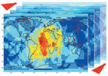
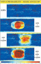
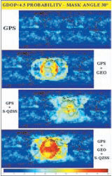
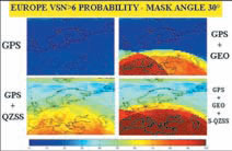
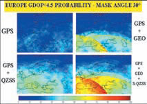
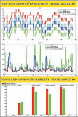
• Considering a single observer for a lot of epochs with a constant mask angle, or a masking changing versus azimuth in order to simulate a real environment. In the first mode VSN and GDOP evolutions versus time are plotted; in the second one VSN and GDOP maps are obtained for a certain area at a fixed epoch. In order to obtain more significant plots, global and regional grids of GDOP and VSN values are generated every 15 min for 24h, producing a 3D matrix of data (Fig.6). Regional resultsTo analyse the global coverage of GPS and its space-based augmentations, we consider a grid of observers placed evenly on Earth surface, with a step of 5° in latitude and longitude; VSN and GDOP are computed w.r.t. every observer at observation epoch. Mask angle values of 15°, 30° or 40° are adopted to represent different visibility conditions. To obtain a complete scenario for a fixed mask angle, probability of VSN>6 and GDOP<4.5 are estimated using a time step of 15 min for 24 hours. Thresholds VSN>6 and GDOP<4.5 are adopted as conservative conditions. With a mask angle 15° the GPS standalone provides a probability to have a VSN>6 of about 100% at polar zones and 80-90 elsewhere and provides a GDOP<4.5 probability near to 90% worldwide. Geostationary and geosynchronous augmentations in this case improve the visibility and GDOP in similar ways and the super-constellation enhances further the situation. Fig.6: Plot of 3D-grid The simultaneous use of EGNOS and S-QZSS satellites with GPS constellation provides of course the best results: VSN>6 probability is 100% and GDOP<4.5 probabilities almost 100% over Europe. At low mask angle (~15°) the standalone GPS is sufficient to guarantee good coverage performances w.r.t. availability and continuity; in this scenario, which certainly doesn’t represents the worst case, EGNOS and S-QZSS could be useful for upgrade accuracy and integrity. A mask angle 30° is a good approximation of a quite adverse but not prohibitive environment for signal propagation and PVT solution. In these conditions the VSN Fig.7: VSN>6 Probability ( mask angle 30°) of GPS constellation is rather poor, the probability to have a VSN greater than 6 is about 10-20% almost everywhere, while over polar zones is 35-40% (Fig.7). The GPS coverage situation is quite critical, in fact the GDOP<4.5 probability is about 20-30% almost everywhere and near to 0% at high latitudes where it’s impossible a precise positioning (Fig.8). The GPS+EGNOS constellation provides a considerable visibility improvement above all on the area defined by footprints intersection of 3 EGNOS SV; this area includes Southern Europe and has a VSN>6 probability about 85-95%. In this area GDOP<4.5 probability is about 50-70%. Also by the sides of this area we note a VSN between 40% and 70%, and a GDOP between 25% and 45%. Comparing with previous case the GPS+S-QZSS constellation improves the visibility in different way; a wider area takes advantages, but with worse performances. VSN>6 probability is 70-80% in Africa, 60-70% in Europe and the benefits of S-QZSS augmentation are clear at higher latitudes too. A similar Fig.8: GDOP<4.5 Probability (mask angle 30°) improvement is obtained for GDOP; GDOP<4.5 probability is 50-70% in Africa and 50-55% in Europe. The superconstellation improves the visibility in both ways: a wide area is well covered with good performances. In this case the VSN>6 probability is 100% in Africa and Southern Europe. Good GDOP coverage is also obtained; GDOP<4.5 probability is between 65% and 90% in Africa and between 60% and 70% over Europe. Fig.9: VSN>6 Probability (mask angle 30°) By the examination of Figures 9-10, which represent coverage performances over Europe with a constant mask angle 30°, we can see that in this condition GPS constellation is insufficient to provide precise positioning. The integration of GEO SVs produces a coverage improvement only over Southern Europe; on the rest of the Europe the coverage remains insufficient, owing to geostationary satellites problems to cover high latitudes. S-QZSS integration produces a good improvement in visibility and GDOP (55-70% and 40-50% respectively), but we can see some continuity issue. The GPS+EGNOS+S-QZSS super-constellation provides a full coverage on Middle and Southern Europe with a VSN>6 probability near to 100% and a GDOP<4.5 probability about 65-80%. Northern Europe is served by at least 6 SVs 60-70% of time, with a good observation geometry about 50% of time; the aforesaid coverage shortage could be overcome, handling geosynchronous orbital parameters. A common urban environment can be simply represented considering an average mask angle 30°; in this condition the superconstellation is suitable to offer good performances with reference to availabilityand continuity thanks to the visibility improvements. The coverage quality is enhanced thanks to GDOP improvement, which causes a more accurate positioning. If S-QZSS is able to broadcast EGNOSlike signals, accuracy will be further enhanced; it should give more probability to receive SBAS correction and integrity message also in urban environment. Fig.10: GDOP<4.5 Probability (mask angle 30°) GPS constellation with a mask angle 40°, is inadequate to provide a continuous and precise positioning; both VSN>6 and GDOP<4.5 probabilities are near to 0%. The super-constellation allows a good Fig.11: Naples coverage evolution (mask angle 30°) Local resultsThe developed software is able to analyse the coverage evolution for a certain period, considering a single observer; this application is useful to study in detail the behaviour of a navigation constellation over a not wide zone. Now we want to examine deeply the behaviour of GPS constellation and its augmentations over Europe; for this purpose we have selected Naples centre area to test the coverage evolutions of the considered constellations. A first analysis is made considering mask angles 15°, 30°, 40° which represent masking conditions of growing difficulty; for a fixed observer VSN and GDOP were computed every 60 seconds in a whole day and a statistical analysis with VSN>5 and GDOP<6 probability is carry out. The observer is placed at Naples at coordinates (φ: 40°50’ N; λ: 14°15’ E). With a mask angle 15° GPS standalone constellation provides good performances: VSN>5 and GDOP<6 probabilities are 100%. For the superconstellation GPS+EGNOS+S-QZSS, VSN is between 11 and 16 and the GDOP value is ever below 3.7. With a mask angle 30° (Fig.11) sometimes the only GPS has a VSN<4, so it’s impossible the determination of 3D fix; VSN>5 probability is about 40% and GDOP<6 probability is about 45%. Instead w.r.t. super-constellation, VSN is between 7 and 13, and GDOP between 2.5 and 8; |
||||



 (No Ratings Yet)


