

Volume XVI, Issue 3, March 2020
Zip
Challenges for validation of automated driving for GNSS
Martin Grzebellus
Living Structure Down to Earth and Up to Heaven: Christopher Alexander
Bin Jiang
Smart total stations in land surveying activity
…
May 2020
China Satellite Navigation Conference
May 2020
Chengdu, China
…
NAV CANADA signs strategic agreement with Unifly
Canada’s civil air navigation service provider, NAV CANADA, has entered into an agreement with Japan-based Terra Drone Corporation’s portfolio company, Unifly, to help drone pilots plan future missions. As a strategic technology partner to NAV CANADA, Unifly will facilitate the deployment of a national system that would provide …
Ecometrica to provide platform for NASA’s latest Earth images
Sustainability and space data company Ecometrica is to help disseminate data from NASA’s latest ‘Global Ecosystem Dynamics Investigation’ (GEDI) LiDAR instrument, thanks to a new contract with the University of Maryland (UMD). The firm’s Ecometrica Platform will make processed maps more widely available to end users …
The ION releases the GNSS Software Defined Radio (SDR) metadata standard
The Institute of Navigation’s (ION) GNSS Software Defined Radio Metadata Standard document has been published and is available at sdr.ion.org.
The Global Navigation Satellite Systems Software Defined Radio Sample Data Metadata Standard is the product of a three year long effort of the ION …
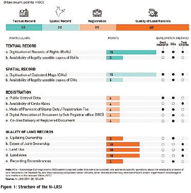
NCAER releases India’s first Land Records and Services Index
National Council of Applied Economic Research (NCAER), released its new Land Records and Services Index (N-LRSI 2020), on Thursday, 27th February, 2020.
The N-LRSI assesses the extent of digitisation of land records and the quality of these land records in the States and Union Territories of India. Madhya …
The fourteenth meeting of the International Committee on Global Navigation Satellite Systems (ICG) was held in Bengaluru, India, from 9 to 13 December 2019 to continue…
KazUAV supports World Bank’s school infrastructure risk assessment initiative
KazUAV, a group company of Japanbased Terra Drone Corporation, has been supporting the World Bank in its initiative to build sustainable school infrastructure in the Republic of Kyrgyzstan. As part of the General-Purpose Simulation Program (GPSS) under the Global Facility for Disaster Reduction and Recovery (GFDRR) …
Agreement on data utilization of EOS with FAO
Japan Aerospace Exploration Agency has agreed to collaborate with Food and Agriculture Organization of the United Nations (FAO) on data utilization of Earth Observation Satellites(EOS), and Imai Ryoichi, JAXA Vice President and Daniel Gustafson, FAO’s Deputy Director- General for Programmes have signed the Memorandum of Understanding at …


 (5.00 out of 5)