| GIS News | |
GIS
NCAER releases India’s first Land Records and Services Index
National Council of Applied Economic Research (NCAER), released its new Land Records and Services Index (N-LRSI 2020), on Thursday, 27th February, 2020.
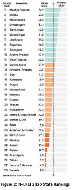
The N-LRSI assesses the extent of digitisation of land records and the quality of these land records in the States and Union Territories of India. Madhya Pradesh, Odisha, Maharashtra, Chhattisgarh, and Tamil Nadu emerged as the top States in the N-LRSI 2020.
The N-LRSI is an integral part of the NCAER Land Policy Initiative (NLPI) launched in 2019 with the aim of filling the gaps in economic research, policy analysis, and systematic data on land. Access to land is a critical factor for economic growth and poverty reduction. For government, industry, and citizens to be able to use this asset effectively and to minimise disputes, it is important to have access to reliable land and property records. Over the years, different states have made significant progress in making their land records digitally available to citizens. The N-LRSI aims to understand the extent of this progress and existing gaps and to identify measures to improve land records in each state.
The 2020 N-LRSI is based on data collected over 2019-20 on two aspects of the supply of land records—the extent of digitisation of land records and the quality of these land records. The first component, which aims to assess whether a state has made all its land records digitally available to citizens, looks at three dimensions—the text of the land records (also called the record of rights), the official map associated with a land record (also called cadastral maps), and the property registration process.
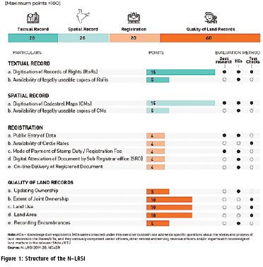
The second component of the Index aims to assess if the land records are comprehensive and reliable–are ownership details updated as soon as a sale occurs, the extent of joint ownership, type of land use, land area on the record and on the map, and are encumbrances being recorded (other claims on the property such as mortgages and court cases). All these elements are closely connected to land disputes and to the ease with which transactions in land can be completed and legally recorded and then conveniently accessed. In his introductory remarks, Dr Shekhar Shah, Director General, NCAER, noted that “The N-LRSI is timely, pioneering work and is already attracting policymaker attention at the Central and State levels. The Index can serve at least three purposes. First, it will help formulate State action plans to attain the goal of secure, assured land records that mirror ground realities and are generated by efficient titling services. Second, the N-LRSI’s comparative assessment of States and UTs will make it possible for the States to learn from each other, with the best performing States showing how the supply of good, reliable, accessible digital land records has been improved. Third, the Central Government can use the N-LRSI to reward and recognise States and UTs that perform better on the Index so that the others are encouraged to improve their standing.”
Talking about the next steps for the N-LRSI, project co-leader Professor Devendra B Gupta said, “The first round construction of the N-LRSI primarily used supply-side data during 2019-20, including proxies for measuring access for citizens, for assessing the extent of digitisation and gauging the quality of land-records services offered. For the second round using data for 2020- 21, a demand-side survey of citizens will be added to gauge the level of public awareness and satisfaction in using digital land records and associated services.”
N-LRSI 2020 Findings
Scoring 60-75 points, Madhya Pradesh, Odisha, Maharashtra, Chhattisgarh, and Tamil Nadu are the five best-performing States on the N-LRSI. West Bengal, Jharkhand, Rajasthan, Telangana, Andhra Pradesh, and Uttar Pradesh are the six States in the 50-60 point category. Figure 1 shows the different components of the N-LRSI and their weights and method of evaluation.
www.ncaer.org
GIS to be set up with mobile app for Haridwar Mahakumbh, India
Upcoming Mahakumbh in 2021 in Haridwar will be put on GIS to enable better management of the mega event along with developing an android mobile application for the pilgrims coming to the Mahakumbh.
MPS Bisht, director of USAC said, “we are set for application and integration of technological tools for the convenience of people and the government. Highquality pictures, maps, rods and other geographical data will be collated for use of the public as well as the authorities”.
Uttarakhand Space Application Centre (USAC) has taken up the task which will be first of its kind effort to manage any of the Mahakumbhs in the country, claimed USAC officials. The setup will be using satellite imagery which would enable the authorities to have real-time data for monitoring of the event. After getting fully developed, USAC will launch to develop a mobilebased application or app to facilitate the pilgrims coming to the Mahakumbh. The plans are to integrate GIS-based data with the help of a dedicated support system to official website of the municipal corporation for accessibility of the same to government and public as per access rights. www.newindianexpress.com
Haulotte launches BIM library
Haulotte has set up a BIM (Building Information Modeling) library on its website. It means construction professionals can now incorporate computer generated versions of Haulotte’s models in their design plans to provide an accurate picture of what equipment is required. www.haulotte.in
Esri partners with Saint Louis University
Esri has entered into an official partnership with Saint Louis University, well-known for its commitment to geospatial research and application. The university recently founded the Geospatial Institute, also known as GeoSLU. The institute encourages students and staff from a variety of areas to explore ways that GIS technology can provide insight into issues affecting the world today, including climate change, access to food and clean water, and economic stability.
Esri will collaborate with Saint Louis University to advance programs focused on these and other areas of global concern. www.esri.com
SSC and Geo-Insights sign MoU
Swedish Space Corporation (SSC) and Geo-Insights (GI) have signed a memorandum of understanding (MoU) for collaborative activities regarding satellite ground station services on the Asia-Pacific market, ultimately expanding their businesses in the region.
The agreement will provide new possibilities for SSC and GI to serve their existing and future customers in Asia-Pacific, currently the fastest growing space market globally. The partners will co-operate to expand satellite ground systems and services in the region by sharing capacity and competence. geo-insights.ai
Urban Links Africa project in Cape Town
Connected Places Catapult has announced the launch of its Urban Links Africa project at an event in Cape Town, South Africa. This flagship project will see joint UK and African innovations deployed to solve pressing challenges in Africa’s rapidly growing cities.
The project’s goal is to facilitate a sustainable collaboration between the UK, South Africa and Kenya by bringing together cities and tech ecosystems through equitable partnerships and industry investment, to address African cities’ key challenges and improve life for citizens.
Funded by Innovate UK, Urban Links Africa (ULA) – which began in September 2019 and will run until April 2021 – will pilot market-led solutions to key urban challenges in Nairobi, Mombasa and Kisumu in Kenya; and Cape Town, Johannesburg and Durban in South Africa. cp.catapult.org.uk
World’s largest platform for air quality data launched
The United Nations Environment Programme (UNEP), together with UNHabitat and IQAir, a Swiss air quality technology company, have launched the world’s largest air quality data platform, bringing together real-time air pollution data from over 4,000 contributors, including citizens, communities, governments and the private sector to work towards healthier, more sustainable cities.
Launched at the Tenth World Urban Forum in Abu Dhabi, this partnership – currently reaching over 15 million users and covering more than 7,000 cities worldwide – aims to sustain and grow the world’s foremost air quality databank.
The data, shared on a single, UNcoordinated platform, will empower governments to take action to improve policy, allow citizens to make more informed health choices and demand action from their governments, while giving businesses the ability to make investment decisions that promote a cleaner, greener environment.
The need to act is urgent. Globally, 7 million people die each year because of air pollution; 650,000 of these are children. Air pollutants not only affect our health, they also affect ecosystems and food production; air pollution is also linked to climate change. Despite this, most citizens don’t have access to real-time air quality data.
The UNEP platform builds upon IQAir’s technology to aggregate, validate and calibrate air quality data that up until now was either restricted to individually-run websites or apps, or not shared publicly. UN-Habitat helps cities to develop plans that can reduce air pollution, including better public transport and waste management interventions. iqair.com
Collaborative cloud construction intelligence management platform by Yovza
Yovza Technologies FZ-LLC, UAE’s most economical Construction Technology solution provider, launched its state-of-theart construction intelligence management platform Yovza.com in Dubai. It is positioned to be an integrated solution that will connect businesses within the construction industry across the segments of four key project stakeholders taking their operations completely paperless. Starting from Engineering Consultants, Main-Contractors, Sub-Contractors and Material Suppliers. The solution will bind together project information and project controls on a single cloudbased collaborative intelligence management platform. yovza.com
Geospatial eXploitation products software with industrial intelligence data
Industrial Info Resources (IIR), provider of worldwide, accurate, and continuously updated industrial facility and infrastructure intelligence and information, has announced that it is providing a global Industrial Intelligence database for integration into BAE Systems’ Geospatial eXploitation Products™ (GXP®) software. Integrated as an image overlay, this database represents the collection, validation, and categorization of humansourced industrial intelligence acquired over three decades from vital industries such as energy, materials, chemicals, manufacturing, pharmaceuticals, food and beverage, as well as supporting infrastructure. www.industrialinfo.com
1Spatial announces new mobile platform for spatial data collection
1Spatial has announced an exciting evolution to its product range. The new Location Mobile App Platform (LMAP) enables easy and flexible spatial data collection whilst in the field. Leveraging existing expertise in data management and data quality into a mobile app platform delivers an easy to use UI, complete flexibility in integration and in-built validation based upon business rules. www.1spatial.com
Fugro selected for Australian Government
The Australian Government has selected Fugro to join the HydroScheme Industry Partnership Program (HIPP) to increase Australia’s hydrographic industry capability. The panel of industry partners was chosen as part of a longterm strategy to ensure safe shipping routes, commercial ports and maritime approaches within the Australian Charting Area. Panel members will acquire marine environmental data to produce digital maps of Australia’s sea and coastal areas that will improve the safety of maritime vessels operating in Australia’s sea charting area, which covers 10 % of the earth’s surface. www.fugro.com
SBG Systems strengthens its presence in Asia
SBG Systems has announced the opening of its new subsidiary in Singapore. Located in the center of the city, this new office brings sales and technical support to the Asian region. www.sbg-systems.com
Doka launches software for formwork planning in BIM
Doka has launched DokaCAD for Revit, its software for automated formwork planning. Efficient formwork systems influence the success of a shell construction project, which requires correct and reliable formwork planning and optimal cycle planning.
The use of building information modelling (BIM) in construction design is a key factor in productivity gains, and BIM models are increasingly used as the basis for formwork planning. www.doka.com


 (No Ratings Yet)


Leave your response!