
Vexcel UltraCam Osprey powers Espoo’s 3D city model
Vexcel Imaging highlights the City of Espoo, Finland, and its continued success in building one of Europe’s most advanced open 3D city models, powered by high-resolution nadir and oblique imagery captured with Vexcel’s UltraCam Osprey systems.
Espoo needed a highly accurate, photorealistic 3D model that would integrate …
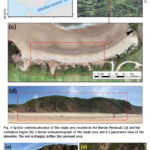
A case study on a beach and rocky cliff
Álvaro Gómez‑Gutiérrez
Instituto Universitario de Investigación Para el Desarrollo Territorial Sostenible, Universidad de Extremadura, Avda. de la Universidad S/N, 10003 Cáceres, Spain
Manuel Sánchez‑Fernández
Instituto Universitario de Investigación Para el Desarrollo Territorial Sostenible, Universidad de Extremadura, Avda. de la Universidad S/N, 10003 Cáceres, Spain
José Juan de Sanjosé‑Blasco
Instituto Universitario de Investigación …

The analysis performed in this report is solely his work and own opinion. State Program: U.S.A (G); EU (E); China (C) “Only MEO- SECM satellites”; Russia (R); Japan (J); India (I)
Narayan Dhital
Actively involved to support international collaboration in GNSS related activities. He has regularly supported and contributed to different workshops of the International Committee on …
Volume 21, Issue 12, December 2025
GNSS Constellation Specific Monthly Analysis Summary: November 2025
Narayan Dhital
…
Moldova’s positioning system now uses Galileo
The MOLDPOS National Positioning System in Moldova has been integrated into the European Position Determination System (EUPOS), a pan-European GNSS augmentation service. The MOLDPOS navigational system uses both GPS and GLONASS, and now Galileo has been added. Creation of MOLDPOS was gradual. First, sites for placement of MOLDPOS stations …

This paper outlines the case of a Canberra homeowner and their architect stretching the planning rules beyond the limits and a surveyor’s critical role in a court case relating to the rules for home construction.
…

The analysis performed in this report is solely his work and own opinion. State Program: U.S.A (G); EU (E); China (C) “Only MEO- SECM satellites”; Russia (R); Japan (J); India (I)
Narayan Dhital
Actively involved to support international collaboration in GNSS related activities. He has regularly supported and contributed to different workshops of the International Committee on …
Ghana opened the joint AfricaGIS 2025 and 11th United Nations Global Geospatial Information Management for Africa conference in Accra on Tuesday, November 17, 2025, with a call for stronger investment and policy changes to advance the continent’s use of geospatial information.
Deputy Minister of Minister of Lands and Natural Resources, Alhaji Yusif Sulemana, said Ghana is …
The Government of Japan has granted approximately 649 million yen (US$4.3 million) to Laos to upgrade outdated topographic maps and establish an online geospatial data system.
A signing ceremony for the Exchange of Notes on the Economic and Social Development Programme (Geospatial Data Platform) took place on October 22 at the Ministry of Foreign Affairs in …


 (5.00 out of 5)