| Reviews | |
Fly around the world for free!
|
|
||||
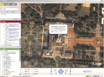
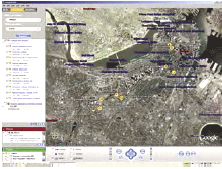
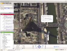
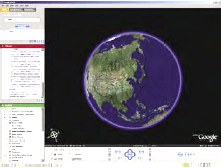
Though internet maps were provided earlier by different players, the interventions of major players such as Google (http://earth.google. com/)and MSN (http://virtualearth. msn.com) have consolidated the internet map industry. Medium and high resolution aerial and satellite maps are available for non-commercial use freely. Both Google and MSN provide satellite imagery maps, of places with street names, locating places. The range of area for which data is provided by Google is the world, while for MSN, it is only USA, though it plans to extend this service to the rest of the world. Of the two, Google has a wider range of services and facilities, and products, such as GPS enabled Earth Plus, and for commercial products. Both the service providers are in the beta phase and plan to provide varied services and products to diverse users. With the entry of these two players, the internet map service industry(map data providers, technical support and technology base and the service providers) is in the process of being overhauled, and consolidated. Google’s Earth Plus can read in GPS data, and thereby create customized maps. A significant quantum of data is open for free (as yet) for diverse everyday uses such as finding directions, locating exotic places, planning for holidays, sites, etc. Besides having opened up the world to everybody at the click of the mouse, internet map providers have melded multiple technologies to give high quality maps which were prohibited and prohibitively expensive in order to provide near real time maps for every day use for either free or at a fraction of the cost of the original maps. These maps are live and technology driven with maps being generated by GPS for individual users, and which are customized. Future trends are demand based- providing real time maps, adaptable to new technologies for generating customized maps. Therefore information is packaged broadly into non-commercial and commercial. The non-commercial segment is primarily free and provides data which is basic-such as finding directions, information about a place, locate your building, locate a site, etc. which enable a vast number of users in their daily lives. Such an exercise is based upon the necessity that only that data which is wired/ mapped is on the screen. Which means that if you are not wired or mapped you don’t exist on the map. Secondly, the challenge that this has for third world countries, especially India, where urban entities have grown organically fi nding your building or your site or the best eatery on the map is going to be a diffi cult task, especially in the absence of street numbers and even house numbers. Finding your home/ a home based business enterprise in Dharavi slum in Mumbai or Munirka Village in New Delhi is going to be a challenging task, which google and msn would need to address in the near future. The changing urban landscapesboth organic and the planned have for long foxed the urban planners/ municipalities themselves. But then, with the increasing demand for real time imagery, GIS and GPS enabled map service providers can provide real time pictures of situations such as the recent fl oods in Mumbai/Ahmedabad in India and also of other disasters, which enable better provision of disaster relief with better disaster management. Readily available basic satellite imagery and aerial photos data is already being used. TV news channels are using satellite imagery in their bulletins. CNN used Google earth imagery in its Breaking News on August 16th, 2005 at 6 pm (IST) to show the site of the West Caribbean Airways airline’s crash site in Venezuela. They showed the imagery of the crash site, and gave basic geographic information of the area based upon the available visual imagery. With the availability of satellite and aerial photographs, a huge market has been opened up, with diverse users using the data now in the public domain. The commercial potential of this data is huge and earth google has multiple products for different users. While basic data is freely available, multiple layered data is available for commercial use for a fee. As of now the products are packaged with multiple users-basic data users. The hardware requirements are that of the confi gurations that are normally integral to a personal computer. Google’s Earth Plus, available for a nominal fee, has crossed the boundaries for customized maps as it is GPS compatible which leads to generation of real time customized maps. The key features of Google Earth are: The entire earth is mapped in medium resolution imagery and terrain data which show major geographic features and towns etc., 3 dimensional maps, seamless ‘viewing experience’, resolution of more than 1 meter. But then, one requires to be on broadband/cable connection. Dial up modem users are out. In India as most of the internet users are on dial up modem, this facility is out of reach. At the click of a mouse the world is at your use. Restricted data is now available. New trend-provide hitherto inaccessible satellite imagery and geographic systems information to anybody who has a broadband/cable connection. Opened up restricted data and made it unrestricted. Now in the reach of the common man. The mobile food carts/pav bhaji/ chaat/gol gappe wala which sustain most of urban India’s office lunch and snack time needs, would go out for a toss, primarily because they are mobile, and their physical space is undetermined in conventional mapping methodology. Salivating food aficionados have gone on expeditions in trying to locate the best pav bhaji eatery which has often been elusive. And those who have been there and eaten, fi nd it hard to give ‘directions’ or to fix the physical space of a joint which has firmly located itself in their mental and gastronomic map. Finally it just boils down to ‘I will take you there’. But this is where the GPS enabled map comes in handy. Foodies now can map the most elusive eatery in urban India thereby making driving directions simple. The one who has gone there and eaten has to use the GPS to map the route and share the map with others. And soon the most elusive eatery would be a thing of the past. By making available free of charge basic GIS/Satellite imagery, India’s national policy of restrictive map disclosure is now challenged. At medium resolution, basic data is available to anyone with a personal computer and a cable/internet connection. And also generate personal map for varied uses. Literally, the map is in your hands. And you make your own map. The world is in your hands, make your own world and your map. From restriction to unrestricted information. Countries with policies of restriction of map information and maps, would now have to address this open access map information. Despite the decided information advantage that a toposheet has over a satellite map, the satellite map scores over the Survey Of India’s toposheet in providing basic information, which is restricted to the Indian public for the restricted zone. India is now opened up to Indians, with the availability of satellite maps as well as the generation of GPS enabled customized maps. There is literally no frontier to breach. The trend of making the latest map information available has begun and will continue. With the availability of high resolution imagery, finally the satellites would fi nally justify their cost, by making the data available to the common man of the world. |
||||


 (1 votes, average: 1.00 out of 5)


