| Agriculture | |
Precision Agriculture
An emerging GNSS research and application area at the Universiti Putra Malaysia. An overview |
|
 |
|
|||||
 |
|
|||||
UNIVERSITI Putra Malaysia (UPM) formerly known as Universiti Pertanian Malaysia was founded in 1971 through the merger of Faculty of Agriculture, University Malaya and Agriculture College in Serdang, State of Selangor. Since then UPM has evolved to become one of the leading universities in agriculture and science in Malaysia.
A variety of research projects at UPM utilize the GPS in the agricultural research through the process of precision agriculture (PA). PA determines the use of spatial aspect of agricultural data to enhance the management activities and decisions by down-scaling the management units from farm to plot, zone and eventually the plant itself. Since the accuracy of measurements is the key in PA, only GPS devices with accuracy of few meters can be used for data acquisition.
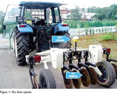
Some of the GPS devices are attachments of other agricultural equipment and are embedded into a system containing computers and sensors to collect data or work autonomously. The Veris system is an example of such a receiver that measures electrical conductivity and variable rate fertilizer and chemical spreader.
Soil variability description for rice precision farming
Electrical conductivity is one of the non-inherent characteristics of soil that can be an indicator of soil nutrients and moisture which are critical for the growth of plants. Therefore it is important to gather information about the mean EC, such as its patterns of distribution in the field. The objective of this study was to determine the spatial and temporal variability of paddy soils using EC and to compare the data from soil sampling with that from the Veris system.
This study used DGPS model AgGPS 132, Trimble attached with VerisEC 3100. AgGPS 132 is mapping GPS differentiated by available beacon station in Lumut (transmission frequency is 298.00 kHz) and provided sub meter accuracy (Figure 1).
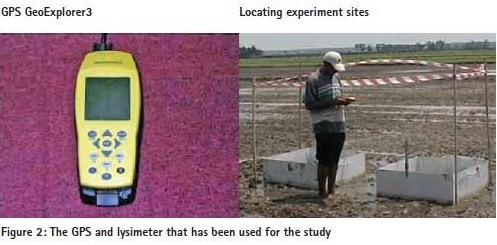
Soil samples were collected for EC zonal characteristics and their locations were recorded by a GPS GeoExplorer3, Trimble with lower accuracy of about 5-15 m. The mapping GPS AgGPS 132 system was successful in EC map generation with the overlay of soil sample location map.
Rice evapotranspiration in paddy fields
Evapotranspiration (which is the sum of evaporation from the surface and transpiration from the plants) is a significant water loss from a watershed. Types of vegetation and land use significantly affect evapotranspiration. The measure of evapotranspiration is important for the estimation of water consumption, ability of soil water filtration and water movements in the soil of paddy fields.
The rice evapotranspiration was estimated using different methods: Lysimetersinstalled inside the paddy field, weather parameters from automatic weather stations installed in the field, and NOAA satellite data (imagery) using remote sensing model. Lysimeter is a device to measure the quantity or rate of downward water movement through a block of soil usually undisturbed, or to collect such filtered water for quality analysis. The location of each lysimeter was determined by hand-held GPS Geo Explorer 3 which has six channels to receive the signals and having 0.25 Mb data storage. The coordinate system for the GPS location data follows the WGS 84 (World Geodetic System 1984) format.
GPS-aided INS for mobile mapping in precision agriculture
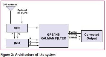
The application of GPS-aided INS for use in Precision Agriculture give farmers accurate and quick updates about the location of the field, even when there is no signal available under the canopy predicting the precision site-specific farming and ultimately contribute towards better yield monitoring and management. The research is in its initial phase and this paper provides an overview of Mobile Mapping Solution for Precision Agriculture by GPS-aided INS Approach. The objective of this study was to build an integrated system using IMU (Inertial Measurement Unit) and GPS Receiver, according to the requirement of Precision Agriculture.
Inertial Navigation is a dead reckoning technique (navigation by calculation), so it suffers from one serious limitation: drift rate errors constantly accumulate with the passage of time. Because its drift errors persistently accumulate, an inertial navigation system that operates for an appreciable length of time must be updated periodically with fresh positioning information. This can be accomplished by using an external navigation reference, such as GPS.
Precision system for mapping tractor-implement field performance
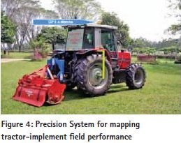
A novel precision system has been integrated on board a Massey Ferguson 3060 agricultural tractor for realtime mapping of tractor-implement performance. The basic system is capable of measuring, displaying, and recording in real-time, the tractor’s theoretical travel speed, actual travel speed, roll angle, pitch angle, fuel consumption rate, drive wheel slippage and drive wheel torque and also implement’s PTO torque, tillage depth, drawbar force, and three-point component forces. With the added DGPS option, the system can be usedfor spatial mapping of the tractorimplement field performances.
A tractor-mounted, automated soil penetrometer–shearometer unit was designed and developed for the purpose of simultaneous in situ measurements of soil penetration resistance and shear stress. A personal computer data acquisition and differential global positioning system (DGPS) on-board tractor were used to assist in real-time measuring, displaying, and recording the tractor position, soil penetration resistance, and soil shear stress during the field sampling operation.
Assessment methodology for impacts of land-use changes on watershed runoff
The objective of this project was to locate the rainfall and stream flow gauges for determining ground truth to test the accuracy of image interpretation and to clarify interpretation assumptions for the land use and land cover classification. For this study of the Upper Bernam River basin, Geoexplorer 3.0 was used that can collect attribute data along with the navigation and positioning. Thus, one can input predefined attribute data along with the automatic logging of the coordinates that are being recorded by the GPS.
Precision Farming at Agricultural Park (TPU)
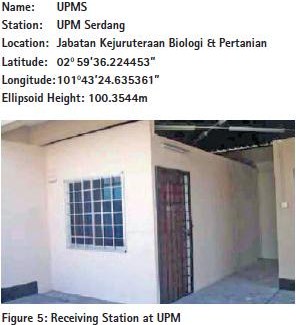
TPU has recently embarked on the precision farming projects and have recently acquired GPS receivers and embedded systems that utilize GPS as part of their operations. The National Survey and Mapping Department Malaysia (JUPEM) have set up a base station at UPM in cooperation with the Department of Biological and Agricultural Engineering and the specifications can be seen in Fighure 5. The GPS Pathfinder Pro XR receiver provides realtime sub-meter accuracy GPS with built-in SBAS, OmniSTAR, and beacon capabilities. Together with your field computer and software, the GPS Pathfinder Pro XRS receiver provides a twoway data flow between the field and GIS, facilitating the data collection and data maintenance processes, and ensuring current data for decision-making. Because the GPS Pathfinder Pro XRS integrates real-time DGPS, it is easy to navigate directly to an asset for verification and updating. By taking advantage of these real-time features, the need for post processing GPS data is eliminated.
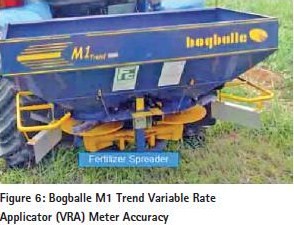
The other system in the TPU is the Bogballe M1 Trend Variable Rate Applicator that is an automatic system for applying the fertilizer variably in the field. The system includes a PDA that has GPS for surveying the field and collecting the position of soil samples, a software that can produce the application maps automatically from the samples and estimate the amount that is needed, a calibrator that is used to manage the data and connect to the GPS and variable rate applicator that is responding to the change in the rate based on the position and data from the calibrator and changes the nozzle of the spreader.
The system is initially set up for the palm oil farms for spreading the solid fertilizer but it is also suitable for different kinds of crops. Universities in all parts of the world are responsible for the spread of knowledge and technology. In this case, UPM is considering taking initiative in the GNSS and spatial technologies through education and research and thus hopes to disseminate the GNSS skills for the benefit of society. UPM has already taken part in the partnerships and working with the government or private agencies to implement this new technology in the real life problem solving.
Acknowledgment
This article has been made possible with the contributions of several researchers at UPM or those affiliated with UPM. We will like to record our appreciation to all who helped make this article possible, especially, W. Aimrun, M. S. M. Amin, Mustafa Yusif, Desa Ahmad, M. M. Hanafi, C. S. Chan, Hassan S.M.H., M.M. Radzali., Shaikh, K.N., H. Jamaluddin, S. Mansoor, M. Tarmizi, Yahya, A., M.Z.Bardaie, A.F.Kheiralla, G.S.Kiat, Ng Eng Boon, Helmi Zulhadie, and Ahmad Rodzi Mahmud.
Our heartfelt appreciation and gratitude to JUPEM for having strongly supported our GNSS related work that helped to jumpstart GNSS teaching and research at UPM.
My Coordinates |
EDITORIAL |
|
His Coordinates |
DATO’ DR ABDUL KADIR BIN TAIB |
|
News |
INDUSTRY | LBS | GPS | GIS | GALILEO UPDATE |
|
Mark your calendar |
FEBRUARY 2006 to NOVEMBER 2006 |




 (No Ratings Yet)



Leave your response!