| Surveying | |
Permanent survey marks in New South Wales, Australia
This paper outlines the journey of permanent survey marks, from manufacture via distribution and preparation of locality sketch plans through to their initial digital occurrence on public record. |
 |
|
 |
|
DCS Spatial Services, a unit of the NSW Department of Customer Service (DCS), is responsible for the establishment and maintenance of the survey control network in New South Wales (NSW), which comprises more than 250,000 survey marks on public record made available to users via the Survey Control Information Management System (SCIMS). SCIMS is a relational database built on three elements: the SCIMS database schema, SCIMS2000 (the forms that allow for interaction and workflows), and SCIMS Online (the customer interface).
Permanent Survey Marks (PSMs) are stable and durable marks (uniquely identified by a combination of letters and numbers), providing a direct connection to the Geocentric Datum of Australia 2020 (GDA2020, see Harrison et al., 2024) and the Australian Height Datum (AHD, see Janssen and McElroy, 2021), as legislated by the Surveying and Spatial Information Act 2002. The form and style of PSMs are prescribed by the Surveying and Spatial Information Regulation 2024 (SSIR) and repeated in Surveyor-General’s Direction No. 1: Approved Permanent Marks (SGD1, see DCS Spatial Services, 2026).
The SSIR also prescribes the requirements for density, general location and construction for each PSM type. Some PSMs are made up of individual components such as brass plates, screws, cover boxes and pins. DCS Spatial Services takes responsibility for the procurement, sale and distribution of PSM hardware to the surveying industry in NSW.
This paper traces the journey of everyday survey marks, from manufacture and assigning of numbers, via distribution, preparation of a locality sketch plan and metadata stored on public record, through to their initial digital occurrence in SCIMS, current at the time of writing. While trigonometrical stations are listed as approved PSMs, they are constructed exclusively by public authorities and therefore not discussed here. Similarly, the physical installation and construction techniques, measurements and accuracy determinations are also not covered.
Form & style of PSMs
The design of PSMs ensures stability and durability in all environments (rural and urban), ease of locating, space for an identifying number, a distinct point for repeatable occupation (horizontally and vertically) and maintains quality during mass production. To achieve this, design drawings that include broad installation instructions were prepared and included in legislative documents, specifically the SSIR and SGD1.
For everyday use, two main types were developed: the State Survey Mark (SSM) and the Permanent Mark (PM). SSMs allow for quicker installation at ground level, generally at street corners along the kerb or footpath. PMs include more substantial marking, particularly in rural situations but also for higher accuracy control traverses, due to higher stability and less likelihood of destruction during construction works.
Urban PSMs (types 2 & 15) were developed for installation in either existing structures (such as already built kerbs, gutters or footpaths) or the same structures while these are being constructed (Figures 1 & 2). Smaller than their rural counterparts, this allows for easier installation, with only a battery-operated hammer drill, 5 mm masonry drill bit, hammer and epoxy resin required versus core drillers running off generators. This was the main reason behind the development of the smaller PSM type 15 (stainless-steel disc and pin). It should be noted that PSM type 15 should only ever be used in an urban situation, while PSM type 2 (brass plaque in concrete) can be used in either a rural or urban environment.
Rural PSMs were designed to account for not having existing structures for installation, thus being more robust. PSM type 1 (brass plaque in concrete) was designed for the two prongs on its stem to be bent out during installation in the setting concrete, providing mechanical fixing with no bonding agent required (Figure 3). These marks were primarily installed by NSW government agencies during the AHD levelling field work in the 1960s and have stood the test of time (Figure 4).
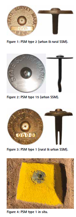
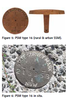
PSM type 16 (brass plaque in concrete) was developed in response to increased damage to type 1 and 2 PSMs. The ‘nipple’ that defines the height reference point is vulnerable to damage from slashers and lawn mowers, making any previously determined coordinates or height suspect. The metal alloy used in manufacturing type 1, 2 and 16 PSMs is malleable enough for slight modification (a distinct advantage) but can be damaged ‘relatively’ easily. DCS Spatial Services intends to phase out type 1 and 2 PSMs due to this vulnerability, replacing these with type 15 and 16 PSMs. Type 1 and 16 PSMs can also be used in an urban situation, with type 16 having a minimalist design that could be used in town centre streetscapes.
The dome of PSM type 16 still allows for a high point of the mark whilst minimising its profile and removing the step of the ‘nipple’ (Figures 5 & 6). The size of the type 16 is a combination of both PSM type 1 and type 2, so no change in tools is required for installation. The hole drilled into the stem allows for a nail to be put through to provide mechanical fixing in setting concrete.
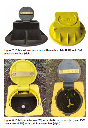
PSM types with the PM prefix can also come in a variety of forms but have two consistent features: a cover box and a brass number plate for identification (Figure 7). Each PM type is designed for installation without any existing structures. The plastic cover box was developed to cater for significant cost increases of the cast iron cover box and safety, weighing less than 2 kg versus 7.5 kg per unit. However, the plastic cover box does have the limitation of reduced strength, so it should not be installed in trafficable areas.
Again, different monument types allow for different environments (Figure 8). A galvanised star picket will not last long in coastal environments, soils with high acid sulphate, saline or alkaline levels or even soils with high water content. In these situations, PSM type 4 (stainlesssteel pin in concrete) is preferred despite the extra volume of concrete required. PSM type 6 (galvanised star picket in soil) has the advantage of non-bespoke monumentation. As star pickets are readily available from retailers across the state, they are not supplied by DCS Spatial Services and its distributors.
Most surveyors install PSMs in relation to cadastral or infrastructure surveys. Over the years, some PSM types have undergone design evolutions and others have been discontinued entirely (London, 2026). While discontinued PSMs are no longer approved for installation, existing ones (in SCIMS) can still be used as such because they were legally approved at the time of installation.
Manufacture of PSMs
DCS Spatial Services has an annual operating budget assigned specifically for the procurement of marks for resale. Procurement of PSMs starts with a tender and contract for each type or element of the PSM. Each tender must be publicly available to ensure a range of prices. Applicable value limits per supplier are constantly evolving to address risks of fraud and ensure competitiveness. For some elements, there are preferred suppliers due to the uniqueness of the components, set-up costs, quality control issues and the relatively small volume.
DCS Spatial Services sells marks as a cost-recovery exercise with the price of most products only rising by the published consumer price index (CPI) each year, unless there are special circumstances. For example, the procurement cost of the cast iron cover box rose by 237% between 2017 and 2023. Even with this steep price increase, the current supplier is still cheaper than others.
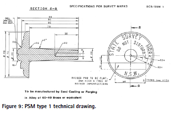
Each PSM goes through a different manufacturing process, sometimes with multiple steps. Technical drawings for each PSM type or individual component beyond those supplied in the SSIR and SGD1 are provided to the tenderers (Figure 9). Each procurement order generally includes 1,000 to 2,000 units to meet both industry demand and ensure the allocated budget for procurement is not exceeded.
Type 1, 2 & 16 SSM casting
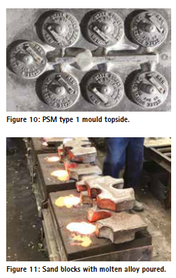
Before manufacture can begin, the casting moulds for each type of SSM need to be set up (Figure 10). If the design changes, the mould changes, resulting in additional costs for the recreation of the mould. DCS Spatial Services purchases the right to own these moulds, enabling their use with different suppliers. However, there have been quality control issues leading to a preferred supplier.
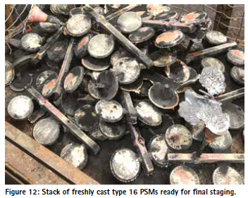
The moulds are then used in the process of sand casting. This involves compressing a block of sand on both sides of the mould to create the voids, separating the top and bottom, removing the mould and then placing the two halves back together. Bar stock of the alloy used for the final product is heated until molten and then poured into the moulds (Figure 11). The alloy used is DCB3 brass, primarily a 60% brass and 40% zinc mixture with small amounts of aluminium, iron, nickel, manganese, lead, tin and silicon. Once cooled, a measure of fresh pure sand is added to the top of each block before it is taken to a shaker, where the sand is shaken off the cast product and recycled for the next round of casting. The cast products are then stacked ready for dressing and final elements (Figure 12).
The excess elements of the casting process are cut off, with edges de-burred and general buffing. The final stage of casting for PSM type 16 consists of the centre to be drilled out as the reference point and a hole drilled in the stem for anchoring (see Figure 5). An individual number cannot be included during mass casting, so the marks are shipped off to another supplier for numbering. That said, the casting stage has included as much of the standard information as possible and is essentially the same for PSM types 1, 2 and 16. The prices to manufacture each differ due to volume of material, complexity during ‘dressing’ and any additional steps (e.g. holes drilled).
Type 1, 2 & 16 SSM numbering
Each mark must be stamped with a unique number. During the early years, duplicate numbers for SSMs and PMs were issued. From mark number 87,200 onwards, the number is unique (i.e. if there is an SS212100, there cannot be a PM212100), primarily due to occurrences of the same number but different mark types being located very close to one another and causing confusion. In this context, it should be noted that SSMs are referred to as SS in SCIMS, due to the SCIMS schema only allowing 2-digit identifiers for the mark type.
For PSM type 1 and 2, an autoadvancing sequential 6-digit stamping die is utilised. A jig is used to seat each SSM in place for orientation, then a hydraulic press pushes the die onto the SSM with a set force. As the press lifts, the number is advanced by one.
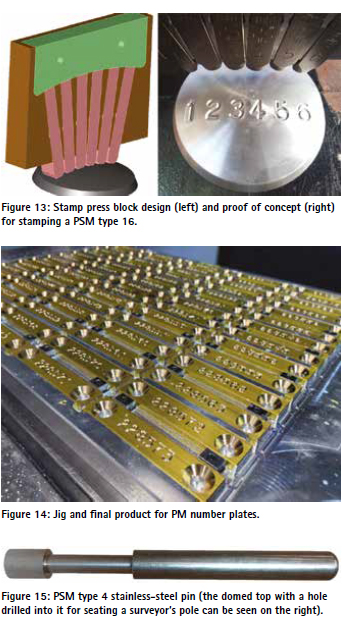
PSM type 16 has added complications because no auto-advancing dies exist to enable an even stamp into its curved surface. DCS Spatial Services had specific tooling manufactured to seat individual number stamps with shims to correctly orientate the stamp (Figures 13). Again, a jig is used to individually seat the SSM at the correct orientation, and then a hydraulic press is used to push the stamps down. As the press is lifted, an operator must manually replace the current digit(s) with the next number(s).
Type 15 SSM manufacture
PSM type 15 development was based on an existing product used for marking by various industries. The general design of a stainlesssteel washer and nail with unique features stamped into the disc has been used in marking footpath seating limits for outdoor eating, identifying the location of underground utilities and as boundary and cadastral reference mark tokens. The type 15 is unique because it includes an individual number for each disc and a hole drilled into the head of the nail to allow for seating of a surveyor’s pole.
The first batches of type 15 PSMs were created using dies to cut and stamp in the one process. The nails are modified off-the-shelf products with the recess drilled into the top as per specifications. The most recent batches saw a different supplier and technique with Computer Numeric Control (CNC) cutting and engraving used for the manufacture of the discs.
PM brass number plate & screws
The brass number plate used for PMs was traditionally created from bar stock with the countersunk holes drilled into them on jigs. Once the blank plates were received, they were sent off for stamping as per the process outlined earlier. This required two lots of procurement for the two different activities and suppliers. The most recent batches have used CNC cutting and engraving with one supplier. The bar stock is placed into jigs for seating during engraving (Figure 14).
These brass plates are also procured for Cadastral Reference (CR) marks having a cover box placed over them and a number allocated for inclusion in SCIMS. The number range of 500,000 to 599,999 has been assigned to CR marks exclusively for ease of identification. It is not intended for all CR marks to be included in SCIMS (as we would quickly reach 7-digit figures), but there are special cases warranting their inclusion. Number plates can also be generated ad-hoc for SSMs that have ended up being covered due to construction or general build-up of material. In these cases, a cover box can be placed at ground level over the top of the SSM and the number identified on a plate.
The screws used for affixing the brass plate to the lid of the cover box are 5/16 British Standard Whitworth (BSW) thread at a ½ inch length, with a flathead screwdriver groove. Not being a common off-the-shelf product, they are made via machining from bar stock of either 316-grade stainless-steel or brass. The stainless-steel option is used for harsher environments with increased probability of corrosion (due to the adhesion of the screw with the cast iron rather than the number plate corroding).
Type 4 PM stainless-steel pin
The 200 mm long stainless-steel pin used for PSM type 4 is created from a 316-grade stainless-steel bar with a machining jig to cut the shape, rotating at high speeds with a lubricant to keep the product cool. This method is very common and used in a variety of manufacturing processes, hence the product has been sourced from several different suppliers (Figures 15).
Cast iron cover box
The cast iron cover boxes used for PMs and other marks are manufactured in a similar process to the type 1, 2 and 16 PSMs. Because of their weight and size, they are not stocked in large quantities at distributors and instead kept in backorder at the supplier. They are delivered to distributors in crates of 50, weighing around 375 kg and representing its own challenge in manoeuvring and storing. Consequently, DCS Spatial Services does not deliver cast iron cover boxes, and they are only available via pick-up from a distributor. For large orders, we recommend ordering a crate of 50 delivered directly to an organisation if storage capacity is available.
Plastic cover box
Plastic cover boxes are manufactured using injection moulding. Similar to the casting process, there are initial setup costs to create the mould. The difference in the moulds for plastic injection is that rather than the mould being one piece creating a cavity in the sand, the plastic moulds are two pieces squeezed together to create a void within the mould to be filled. As we have two separate components to a cover box (i.e. box and lid), there are a total of four moulds.
Plastic pellets are dried, heated and compressed to a molten state and pushed into the moulds. The plastic has additives introduced for colour and ultra-violet light stabilisation. The box and lid are then drilled out for the introduction of a hinge, for which a stainlesssteel pin is used to help find the monument with a metal detector when obscured by grass or soil.
Distribution of PSMs
PSM hardware is distributed and sold through DCS Spatial Services regional offices or partnered local private firms, with the SCIMS team under the Office of the Surveyor-General responsible for overall coordination. The full list of distributors is maintained as an appendix in SGD1 and subject to change regularly. The current price list is updated at the start of each financial year and available on the DCS Spatial Services website.
Customers order hardware either by emailing the SCIMS team or contacting the local distributor. Payment is made by account system with invoices emailed on a monthly basis. For each order, a mark issue spreadsheet is prepared by the distributor, recording the customer and hardware ordered and including calculations with checks in place to ensure correct quantities. The data entry for numbered marks is for the first and last numbers issued, with the quantity automatically calculated.
These mark issue sheets are then sent to the SCIMS team for entry into the Survey Services Database (SSDB), which not only records who PSMs were issued to and at what cost but also generates the sales file for uploading into the accounting system that automatically sends out the monthly invoices. The SSDB is also used for tracking general distribution (where stock is) and to record when a Locality Sketch Plan (LSP) has been received for an issued mark.
The SSDB has gone through many versions over the years, starting out as a spreadsheet, transitioning to a relational database built in Microsoft Access with macros, and is now a Microsoft PowerApps application. Since financial year 2017-18, on average 2,960 numbered marks are distributed to industry per year (23,700 total to financial year 2024-25). In the same time period, we received an average of 2,415 LSPs from industry (19,326 total to financial year 2024-25).
LSPs and SCIMS initialisation
The SSIR requires that the SurveyorGeneral be notified within 2 months of the placement of a new PSM or by the same day a plan is lodged for registration (generally via LSP lodgment to the SCIMS team). Guidelines for the preparation and lodgment of LSPs can be found in Surveyor-General’s Direction No. 2: Preparation of Locality Sketch Plans (SGD2). LSP forms and templates in different electronic formats are available on the DCS Spatial Services website (DCS Spatial Services, 2026).
LSPs provide connection to real-world features to help locate the survey mark. They are extremely useful for finding marks in rural and remote areas, especially when dealing with a lack of mobile phone coverage or low sky visibility limiting the use of real-time positioning services. The main advantage of LSPs in urban environments is determining if the mark has been relocated or disturbed (changes in the surrounding features and the measurements to those are strong indicators).
The SCIMS team performs quality assurance on the submitted LSP, including:
• Does the mark already exist in SCIMS?
• Does the LSP comply with SGD2 specifications, i.e. could someone find the mark from the information given?
• Is the LSP free of errors?
• Has the LSP been submitted by the same organisation that purchased the mark?
• Converting the supplied file into the required format and specifications (*.tiff, black & white, 200 dpi).
• Ensuring the file name matches the mark type and number.
The SCIMS team then uses EDMARK, an in-house mapping product, to plot the new mark. This provides quality assurance on the correctness of the information supplied on the sketch, such as coordinates, street names and suburb. EDMARK also enables calculation of a height value from the statewide Digital Elevation Model (DEM), helping to validate the height value supplied or providing a height when none was supplied.
The plotted marks first sit in a staging table within SCIMS2000 and are checked again by another staff member to ensure no gross errors are present (e.g. incorrect sketch loaded for a particular mark). Then they are loaded into SCIMS, allowing the public to order the mark’s coordinates and LSP through SCIMS Online or associated webservices and (mobile) applications.
All marks plotted with EDMARK have the one source ID (job number) in SCIMS and are given an accuracy Class U (i.e. unknown) both horizontally and vertically. This intentionally low accuracy classification reflects the fact that the coordinates supplied have not gone through a rigorous least squares network adjustment to determine Class and Positional Uncertainty (PU).
In this context, it should be noted that customers have the opportunity (and are encouraged) to submit static Global Navigation Satellite System (GNSS) datasets of at least 2 hours duration collected on the new mark to DCS Spatial Services via its Customer Hub for inclusion in the monthly SCIMS update based on AUSPOS, Geoscience Australia’s free online Global Positioning System (GPS) processing service (Maile et al., 2026). Assuming sufficient data quality and appropriate sky view conditions, this generally results in updating the coordinates and accuracy classification of the mark to Class D (i.e. established in a cadastral context) in a timely manner (Janssen and McElroy, 2022).
Once stored in SCIMS, the team completes the remaining metadata entries for the new mark in SCIMS2000 and the SSDB. This includes date placed, placed by (organisation), monument type (generally PSM type), monument location (generally ground level) and LSP date.
Sometimes the first notification of the placement of a PSM occurs when DCS Spatial Services is processing a Deposited Plan (DP) for entry into the Digital Cadastral Database (DCDB). The coordinate schedule on the plan identifies the PSMs shown on the plan and issued to accurately plot the boundaries. If the PSMs shown in the coordinate schedule are not present in SCIMS, this is flagged with the DCDB team and results in the SCIMS team being notified. The SCIMS team then uses the DP information to plot the mark and sends a request to the surveyor for the submission of an LSP. If a surveyor comes across a PSM in SCIMS and discovers that no LSP is available, no LSP has been submitted by the organisation or surveyor that placed the mark. If such a mark is observed, it is good practice to produce and submit an LSP of the mark found.
Early LSP forms did not have fields for coordinates, so the initial coordinates would be scaled off topographic maps. Due to scaling errors, some marks were mis-plotted, sometimes by hundreds of metres. If one of these marks is discovered, the revised spatial position can be supplied to the SCIMS team either via a mark status notification or submission of an updated LSP. The team will then use EDMARK to update the mark’s coordinates and load the updated LSP.
Conclusion
PSMs are an integral piece of infrastructure for NSW, providing the connection to a common datum for the work undertaken by a multitude of industries. What appears like a simple piece of brass on the street corner is actually highly complicated. This paper has outlined the journey of everyday survey marks, from manufacture and assigning of numbers, via distribution to surveyors, preparation of a locality sketch plan and metadata stored on public record, through to their initial digital occurrence in SCIMS. The form and style of PSMs is continuously evolving, and DCS Spatial Services welcomes any feedback on potential improvements or alternatives to consider.
References
DCS Spatial Services (2026) SurveyorGeneral’s Directions, https://www. spatial.nsw.gov.au/surveying/ surveyor_generals_directions (accessed May 2026).
Harrison C., Brown N., Dawson J. and Fraser R. (2024) Geocentric Datum of Australia 2020: The first Australian datum developed from a rigorous continental-scale adjustment, Journal of Spatial Science, 69(1), 167-179.
Janssen V. and McElroy S. (2021) The Australian Height Datum turns 50: Past, present & future, Proceedings of APAS Webinar Series 2021 (AWS2021), 24 March – 30 June, 3-27.
Janssen V. and McElroy S. (2022) A practical guide to AUSPOS, Proceedings of Association of Public Authority Surveyors Conference (APAS2022), Leura, Australia, 21-23 March, 3-28.
London M. (2026) Permanent survey marks in NSW: From manufacture to SCIMS, Proceedings of Association of Public Authority Surveyors Conference (APAS2026), Bowral, Australia, 16-18 March, 20-53.
Maile T., Masoumi S., Wang C., Riddell A. and McClusky S. (2026) Analysis of the AUSPOS v3.0 positioning service after alignment to ITRF2020, GPS Solutions, 30(1), 52


 (4 votes, average: 1.00 out of 5)


Leave your response!