| Application - New | |
Land adminsitration and climate resiliency
How do we administer land in an environment where limitation of land exists yet relocation of communities due to inundation is a must? |
 |
|
Abstract
Fiji has land ownership in Fiji are three different tenureship in state land (4%), native land (90%) and freehold (6%). With 90% of native land ownership, there lies traditional and sentimental ties to the land and its protocols. Exposure to climate change is experienced daily and the nation has voiced the impacts in any platform possible. How do we administer land in an environment where limitation of land exists yet relocation of communities due to inundation is a must? What is development and economic gain in the face of green policies and international best practice? How do we compensate for such traditional values if communities are relocated? To answer these, lands administration in Fiji is working towards digitization using updated technologies to consolidate a national database. State incorporate green policies ideas in work plans such as how mangroves and forest degradation impacts their livelihoods and also their future sustenance. With such climate change experienced, the question for Fiji-where to from here?
Introduction
In Fiji, land administration is guided by the types of land tenure ship that is administrated by State and other agencies. There are three types of land tenure:
• Native land ownership which owns a majority of land in Fiji. These are traditional clans or indigenous Fijians (iTaukeis) owning lands that are administered through the iTaukei Land Trust Board. The composition of this tenure is 91% of lands in Fiji. Most of the local indigenous communities use these parcels for subsistence farming, establishment of villages and other communal activities they think is best for them.
• State lands are land parcels owned and administered by State for identified purposes. This comprise of <4 % of total lands in Fiji. These parcels were taken initially by State for nation building and development. Some are classified as Crown Grants, Crown Freeholds, Native Lease to State and State Lease etc. However these lands were initially owned by native indigenous communities before the colonists entered Fiji and tried to establish a Western type government for which these lands were given.
• Freehold Lands-these are usually privately owned by Fijians that have outright authority over their property.
In trying to combat climate changes, land administration or development strategies should account for land loss through sea level rise, vulnerability to food inundation, loss of fertile agricultural land and most importantly consideration for best practices to combat climate changes.
In the United Nations publication of 1996, Land Administration Guidelines, the main focus was to outline the benefit of having a reliable and relevant land information system. With the growing population, half of humanity now lives in cities and towns and by the middle of this century 70 % of the world’s population will live in urban areas (2012).
Fiji with its landmass of 18, 272 km2 and approximately houses 57 % urban centers it is imperative that Fiji reviews its land administration system to ensure its vibrancy in a changing climate (2019) .
Objectives
This paper provides information on how land administration has been impacted by natural climatic changes that challenges the cornerstone of development economically and socially.
Background
Fiji recently is progressing its Climate Change Bill which will guide the legal mandate of government in terms of ensuring resiliency. Together with this, the National Disaster Risk Reduction Policy was endorsed which will be implemented in trying to achieve the targets of the Nation’s Development Plan.
According to a World Bank country assessment (NDDR 2018- 2030), it was noted that:
• Fiji has an inherently high potential of exposure to an array of natural disaster;
• Fiji is also vulnerable to human induced and technological disasters;
• One of the contributing factors to its vulnerability is poorly planned land use and development and poor infrastructure; and
• Lack of preparedness in terms of disaster awareness.
In progressing Fiji’s resilience to climate change and other socio-economic disasters, a fundamental progress needs to be seen with land administration processes.
Land administration
In Fiji the absence of preplanning and strategies have contributed to an increase in population in peri-urban and urban centers; conversion of prime agricultural land for commercial ventures and lack of land use planning. All these contribute to informal settlements; erosion; ocean and waterways pollution; increase in flooding and landslides.
There are a number of government agencies that work in coordination in the leasing of state land. They each make their technical expert advice to enable the lease to be issued. They make assessments on types of land use; zonation; environmental impacts and boundary definition. There is a clear need for the development in these areas as Fiji tries to build climate change resilience and also ensure food security and livelihoods for its people.
Disaster impacts
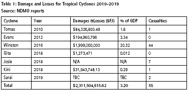
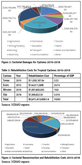
In 2016, a Category 5 cyclone struck Fiji which affected 60% of the nation’s population. Widespread damage could be seen with infrastructure, agricultural lands, health and education facilities and approximately more than 40000 houses destroyed. Such fierce cyclones, floods and bushfires are predicted with climatic changes affecting the world.
Fiji as a signatory to the Sendai Framework, has used the data post disaster to boost its campaign to launch the National Disaster Risk Reduction Policy in 2020. This policy aims to enable the nation Fiji to deliver on its priority of preventing new disaster risk and reducing existing disaster risk in line with relevant regional and global frameworks.
Disasters in Fiji are categorized in to 3 (I, II and III) with specific levels of targets hazards and disasters.This will also assist is planning strategic post disaster approaches and economic impacts.
Types of disasters
During floods and heavy rainfall, agricultural lands are affected together with residential communities near waterways such as creeks and rivers. Landslips are now frequent due to the changes in climatic or weather patterns which favor such hazards. Therefore, for any land allocated for any form of land use, determination of ground stability is now a criterion.
Current processes
Statutory framework
The state administers State lands within the ambit of the State Lands Act of 1945. The law determines the ambit within which state lands should be administered with the assistance of other laws such as the River and Streams Act (1880), Land Use Act (2010), Land Sales act (1974), Land Transfer Act (1971), Surveyors Act (1969) and the Property Law Act (1971).
These laws were formulated ages ago and have not anticipated the drastic changes these climatic conditions would impact state lands and land use. Development has progressed over the years and these laws have remained without review to address the modern changes.
In administering lands processes there are also other associated laws that assist or need to be considered. A few of these are the Environment Management Act (2005), Mining Act (1965),I Taukei Lands Act (1905), Forest Act (1992). In process now are two important policies namely the Climate Change Bill and Oceans Policy which will affect foreshore lands management and mangrove plantations conservation efforts.
State initiatives
There are a few state initiatives or supported programs which also impacts lands administration. These are REDD+; planting of 4 million trees in 4 years; digitization of the government information and processes; formulation of the mangrove management plan and other international dialogue that would promote environment conservation and sustainable development.
Lands administration processes
The allocation of state land follows an approved process that is mandated by the relevant laws. Valuation and inspection are undertaken and all contributing factors are considered before survey and leasing of land is approved.
However, the department of lands now does employ modern technologies for assessments and surveys such as using drones and geospatial information analysis to asset in such land developments.
To ensure ground structural; stability, geo-technical survey is being required to inform the state if locations are suitable for the land use form that is to be assigned.
Environment assessments which have its own laws and processes are now given importance to ensure that tenants or landowners are informed correctly on the impacts of climate change on their piece of land. Zoning of the areas as in town planning plans are also considered to allow for sustainable yet coordinated development to be undertaken.
Also there is allowance for the land bank processes where native lands are acquired by the state, deposited in a land bank for economic developments or initiatives.
Fiji is undertaking its Agricultural Census and Forestry is also embarking on taking stock of all forests in Fiji. These are initiatives of government ensuring that projects undertaken by state are environmentally sustainable and climate smart.
Results
In the last decade, Fiji has realized the adverse impacts climate change will bring to the country with its island setting and wide oceans surrounding.
The national development plans started to gradually incorporate climate change adaptation measures which are now implemented and part of the nation’s strategies.
Fiji is not resource rich but is land rich in the sense that 91% of lands in Fiji are owned by indigenous landowners or iTaukeis. Only 3-4 % of Fiji lands belong to the state with the balance titled freehold lands. Most of the developments in after disasters and most likely in future will need land that is acquired from these landowners.
Mostly government needs or projects for national purposes are prioritized whereby state acquires the land through the department of lands. Such are government stations in the rural areas, water or electricity facilities, roads, hospitals and public areas such as sporting grounds.
The use of new information and modern technologies has improved the:
• Timelines in processing of leases
• Accounted for environment degradation
• Driven the formulation of necessary legislations and action plans
• Facilitated in the establishment of resource surveys and the relevant auditing or monitoring structures
• Adherence to global programs and developments
• Increasing of an awareness within the country of impacts of climate change and importance of national readiness
• Diversifying of focus on land administation to be incorporate other relevant factors such land use information, town planning criteria and environment management strategies.
Climate resilience
What is resilience? According to the definition in the Oxford Dictionary, it is the ability or the capacity to recover quickly from difficulties; the toughness or elasticity of a substance. In the context of this paper, climate resilience can be defined as the capacity for a socio-ecological system to:
• absorb stresses and maintain function in the face of external stresses imposed upon it by climate change;
• adapt, reorganise and evolve into more desirable configurations that improve the sustainability of the system, leaving it better prepared for future climate change impacts (Folke, 2006).
• Climatic changes could be used as opportunities to improve systems or innovate and evolve into new systems. Resilience includes adaption but more so of the ecological systems to improve in absorbing changes but reconfigure itself to develop into a more efficient configuration (Nelson, Adger, & Brown, 2007) . Discussions on these issues including vulnerability cannot be made in isolation as smaller countries especially in the Pacific have discovered. It has to be taken into totality so as to drive the efforts dedicated in building resilient communities in the Pacific.
Currently in the Pacific, the socioecological systems no longer operate under the assumption that if any changes occur, the system will involuntarily work towards an equilibrium or stable point. In this age of vulnerability, changes are harnessed to provide new baseline of operations. This drove the changes that the Pacific Island Countries are advocating for the facilitation of changes in adaptive management and environmental resources (Tompkins & Adger, 2004).
In the PICs, livelihoods are entrenched in the natural ecosystems that surround their lives and if any one of such ecosystems is affected, it provides a domino effect in that it attacks the foundation of all. Therefore PICs are using the platform of climate resilience to address global warming issues and sea level rise impacts.
The local scenario-Fiji
In Fiji, the changes in the weather patterns, in terms of temperatures, flash flooding from heavy rainfalls, sea level rise and many others are becoming resoundingly loud making the country a mouthpiece for all PICs in campaigning for the reduction of carbon emission. Fiji as was announced by the Prime Minister, Mr. Voreqe Bainimarama at the recent Special Session on Urban Culture and Climate Change Action in Abu Dhabi, is driving towards being carbon neutral by 2050 (2020).
The state has now tried to incorporate these new pathways into its lands administration processes. Some of the changes it is embarking on implementing are:
• Digitisation of land information – for leasing and property ownership the nation is trying to reduce the amount of paper that is used. This reduces fuels costs as well in terms of electricity, man-hours, office space and ultimately will reduce time for processing. This enhances coordination between they state agencies and stakeholders, introduces a more transparent system and more access to information which may lead to critical decisions being made efficiently.
• Use of technology in mapping and survey works-state has begun employing drones or unmanned aerial vehicle to monitor its leases utilization, boundary definitions and also to assist in compensation discussions. These technology in using Remote Sensing and GIS has facilitated the production of better maps and also consolidation of all information pertaining land development making it easier for decision and policy makers to determine direction for national development.
• Introduction of environmental impact assessments and climate smart innovations in administration processes thus creating a holistic approach in endorsing land use types for state lands. With its EMA (2005) legislation, any development that will cause a disturbance to the natural environment requires and EIA which will consider any mitigation measure that the developer may employ.
• The education and awareness created in the people to appreciate the statues of our environment and partner with the government in trying to curb the fast growing changes brought about these climate changes.
• Formulation of relevant policies such as the Mangrove Management Plan, Climate Change Bill, Fair Share Act, Ocean’s Policy, National Climate Change Policy, National Distaster Reduction Policy and also Fiji’s National Adaptation Plan Framework. This is in addition to efforts by each agency of government to formulate policies relevant to its targeted plans. Through these platforms of advocacy, a 5 and 20 years National Development Plan was compiled where each responsible agency whether private or state (including state owned enterprises) are given targets to achieve. This has clarified and defined the work to be done and minimizes losses and wastage.
• At the grass root level, adaption efforts has taken many forms ranging from sea-wall and flood defenses construction, setting up of early warning systems as in earthquakes and tsunamis, groundwater development for drought stricken agricultural lands and reinforcement designs for areas vulnerable to landslips. These are changes made with the coordination and contribution of the lands department in the effort of building resilient communities.
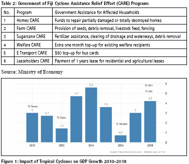
• The Government of Fiji also has comprehensive disaster recovery programs that assist affected households in recovering from the impacts of disasters. In addition to sectorial rehabilitation programs, the Government following Tropical Cyclone Winston introduced the Cyclone Assistance Relief Effort (CARE) program to enable the public to return as quickly as possible to normalcy.
The state continued to support the people in Building Resilient Communities and Build Better People efforts to ensure that the nation is prepared for future disasters.
Landslides
A record of 100 landslide events occurred since TC Winston and these were surveyed and mitigation strategies were recommended for recovery where home destructions occurred and lives lost.
These landslides usually occurred during heavy rainfall and cause road blockages, destruction of infrastructures, river bank collapses and at times loss of human lives.
The state now requires a geotechnical assessment determining the stability of the ground to be made by developers prior to any development commences.
Also the construction sector has now revised the building codes to implement practices that will ensure infrastructure built in future will be able to withstand Category 5 Cyclones and also major earthquakes.
Earthquakes
There has been more than a 1000 events that have been detected locally and also regionally. Recently there was felt tremors on the island of Kadavu which caused massive cracks and landslides of the highest peak of Mt. Washington.
Conclusion
The goals of land policies vary but most will include poverty reduction, sustainable agriculture, and sustainable communities for human settlers, equity and economic development. But what do we do with the pressing issues of relocation, inundation, loss of land fertility, sea level rise all which are brought on by climate change?
In conclusion, this paper is to establish the context of the need to modernize land administration in vulnerable nations such as the PICs to ensure that people have security of tenure as well as safe livelihoods in the increasing impacts of climate change. Evidence as shown in this paper demonstrates include that the strengths of cyclones have increased, earthquakes and tremors are more frequent, and landslides due to long dry seasons followed by high rainfalls are more. The economic loss challenges these developing nations yet there is determination to soften the blows from these disasters and build better and stronger infrastructure and also resilient communities
References
Folke, C. (2006). Resilience: The emergence of a perspective for social–ecological systems analyses. Global Environmental Change, 16(3), 253–267. doi: 10.1016/j.gloenvcha.2006.04.002
Geography of Fiji. (2019, October 16). Retrieved from https://en.wikipedia.org/ wiki/Geography_of_Fiji
UN-HABITAT. (2012). Handling land: tools for land governance and secure tenure. Nairobi, Kenya.
https://www.fiji.gov.fj/Media-Centre/ Speeches/Prime-Minister-Hon-Voreqe- Bainimarama speech at Special Session on Urban Culture and Climate Change. (2020, February 10). Fiji Sun.
National Disaster Management Office. (2020). Impacts Of Tropical Cyclones And Rehabilitation Efforts In Fiji From 2010-2020. Suva, Fiji.
UN. (1996). Land Administration Guidelines. Nairobi,Kenya.
Nelson, D. R., Adger, W. N., & Brown, K. (2007). Adaptation to Environmental Change: Contributions of a Resilience Framework. Annual Review of Environment and Resources, 32(1), 395–419. doi: 10.1146/ annurev.energy.32.051807.090348
National Disaster Management Office. (2016). Report on Tropical Cyclone Winston. Suva, Fiji.
Tompkins, E. L., & Adger, W. N. (2004). Does Adaptive Management of Natural Resources Enhance Resilience to Climate Change? Ecology and Society, 9(2). doi: 10.5751/es-00667-090210
The paper was prepared for presentation at the “2020 World Bank conference on Land and Poverty ” The World Bank – Washington DC, March 16-20, 2020.


 (1 votes, average: 3.00 out of 5)


Leave your response!