| Mapping | |
Improving Indonesian Geospatial Information establishment
This paper intends to share experiences in Improving the quality of GI establishment by developing standards, human resources, and the certification implementation process in geospatial sector in Indonesia |
 |
|
 |
|
 |
|
Developments in the era of advanced science and technology nowadays is a challenge and an opportunity, especially in the field of geospatial information in Indonesia. As stipulated by the Act 1945 article 28 F that every person has the right to obtain information including Geospatial Information (GI), new chapter related to the implementation of the GI had begun with the enactment of Act Nr. 4/2011. GI has been organizing activities from upstream to downstream in surveying and mapping activities as this is more important for policy formulation, decision making, and implementation of activities that are closely related to spatial and terrestrial. In book II of the National Medium- Term Development Plan (RPJMN) from 2015 to 2019, based on the vision and mission of the President of Republic of Indonesia, as well as the agenda of national development priorities (Nawa Cita), the role of GI be very important in supporting the distribution of development between regions, including rural development, the infrastructure provision and basic social services for the public, and economic development that is focused on the food sector, energy, maritime and marine, and tourism, which is presented on topographic mapping, spatial mapping, boundary mapping, thematic mapping, and marine and coastal environments mapping.
Generally, GI in Indonesia is divided into Basic Geospatial Information (BGI) and Thematic Geospatial Information (TGI). BGI includes a national reference network (geodetic network: national horizontal geodetic control networks, national vertical geodetic control networks, and national gravity network), and a base map (a map which consists of coastline, earth’s relief (hipsografi), waters, topographical names, boundaries, transportation and utilities, buildings and public facilities, and land cover). Important features of BGI are the objects can be seen directly or measured by physical appearance on the earth and that has not changed relatively in long period. TGI presents many themes with its special parameters related to mapping, such as forestry, agriculture, fisheries, and mining, etc. TGI must be based on BGI so the scale of TGI is not greater than BGI as its reference, besides position and level of geometric precision of BGI must not be changed.
According to a press release of the Ministry of Communications and Information Technology, due to the TGI which overlap each other, the implementation of development programs both regional development and infrastructure are often confronted with a number of conflicts related to space utilization. The policy’s principles among others are conducted by coordinating against any activities that must be implemented by each Ministry/ Institution (M/I). Afterwards, every M/I related to the preparation of TGI scale of 1:50,000 according to the action plan stipulated in the Presidential Decree on Acceleration of the Implementation of One Map Policy (Ministry of Finance Republic of Indonesia, 2015). Indonesia has Presidential Regulation Nr. 9/2016 on acceleration of the implementation of one map policy on level of map accuracy scale 1:50,000, which is set in the Eight Economic Policy Package. This is intended to reduce the potential for conflict due to the utilization of space or land use. In order that GI can be held orderly, integrally, effectively, and efficiently, to ensure GI accuracy, up-to-date, and legal certainty, there are arrangements regarding the organization of GI. The same reference base map will increase the reliability of information related to the location of economic activity.
Relevant sectoral ministries have agreed and collaboratively established the One Map. Some ministries have started to establish their own thematic maps developed from the basic map. The public participated to some degree, as community-based organizations gave inputs to revise the original map. The preliminary form of this map has been used in several pilot licensing projects to prevent overlap. This map built on existing initiatives, namely the National Spatial Data Network, and will be used as the only reference of basic geospatial information. This map will also serve as one standard for thematic mapping, whereby sectors may produce thematic maps to serve their purposes by using mapping standards approved by BIG so they can be integrated with other themes to create a national thematic map (Shahab, Nabiha, 2016)
Based on Article 53 of the Act Nr. 4/2011, Government is obliged to facilitate infrastructure development of the Geospatial Information to carry out the implementation of the Geospatial Information. Geospatial data and information utilization on the planning process and the development of public policy currently is still not optimal. Indonesia is still in preparation process to integrate and to harmonize GI (BGI and TGI) through a standard starting from identification of IG needs, GI evaluation of existing standards, as well as harmonization of standards. The high demand for geospatial data and information should be anticipated, and hence standards become a necessity as the standard reference in the implementation of GI activities. It is important to strengthen the national position of the GI facing natural movement in the level of Association of Southeast Asian Nations (ASEAN) and in global market level. Currently, Geospatial Information Agency (BIG) as competent authority of surveying services in Indonesia is participating in equalizing national competency in ASEAN surveying services level through Mutual Recognition Arrangement (MRA).
Standard for implementation of the geospatial information
Direction of development of geospatial information standards in Indonesia is affected by BIG function in implementing the tasks as defined in Article 2 of Presidential Decree Nr. 94/2011, related to the basic geospatial information (BGI), thematic geospatial information (TGI), and geospatial information infrastructure (GII). Standard is one of the GI infrastructures beside policy, institutional, technology, and human resources. Classification standards that will be used for implementation of the Geospatial Information includes: 1) standard for geospatial data collection; 2) standard for geospatial data and information processing; 3) standard for storage and securing geospatial data and information; 4) standard for dissemination of geospatial data and information; and 5) applications of geospatial information.
There are 90 national standards (Standar Nasional Indonesia – SNI) related to implementation of GI have been produced, both identical adoption and modification of the international standards (ISO), and standards from independent formulation according to national needs (Badan Informasi Geospasial. 2016a).
1) Some of ISO adoption are: reference model; spatial referencing by coordinates; spatial referencing by geographic identifiers; quality principles; quality evaluation procedures; conceptual schema language; extensions for imagery and gridded data; XML schema implementation; web map server interface; services; data quality measures; web feature service; imagery, gridded and coverage data framework; positioning services; observations and measurements; methodology for feature cataloguing; imagery and gridded data; classification system structure; Land Cover Meta Language (LCML); quality assurance of data supply; Geography Markup Language (GML); schema for coverage geometry and functions; Land Administration Domain Model (LADM); Geospatial Digital Rights Management Reference Model (GeoDRM RM); Place Identifier (PI) architecture; imagery sensor models for geo-positioning; calibration and validation of remote sensing imagery sensors and data – part 1: optical sensors; etc.
2) Some of the independent formulation are: technical specifications of the topographic map on level of map accuracy scale 1:10,000; technical specifications of the topographic map on level of map accuracy scale 1:25,000; technical specifications of the topographic map on level of map accuracy scale 1:50,000; technical specifications of the topographic map on level of map accuracy scale 1:250,000; mapping specification of peatland on level of map accuracy scale 1: 50,000 using remote sensing data; survey and mapping of mangrove; horizontal geodetic control networks; vertical geodetic control networks with leveling methods; gravity control network; classification coverage of the seabed; hydrographic survey using single beam echo sounder; bathymetry survey using single beam echo sounder; base map accuracy; spatial metadata; etc.
BIG is in collaboration with National Standardization Agency of Indonesia (BSN) which have missions to develop and organize standardization activities in Indonesia. Implementation of existing GI standards must be maintained and monitored. Maintenance is done by review mechanism process (kaji ulang), which is conducted at least once in five years. If there are new standard needs in the field of GI based on development of science and technology, the development of SNI is carried out through the following stages: Stage 1: Programming SNI; Stage 2 Formulation of the Plan SNI (RSNI); Phase 3 Polls RSNI3; Stage 4 of the Agreement RSNI4; Stage 5 Determination of SNI; and Stage 6 Maintenance SNI.
Besides providing national standards (SNI), BIG also evaluate the development of standard operational procedures (SOP) on implementation of GI in 2017.
1) Results on implementation of BGI:
▪ from 61 existing SOPs on classification geospatial data collection related to photogrametry and remote sensing, geodetic control network and geodynamic, and hydrography, there are 22 SOPs need modification (i.e., SOP regarding radar data collection, lidar data collection, ground control point measurements for mapping by Ifsar, etc), 1 SOP must be deleted because mechanical optics-based on photogrammetry processing is not used anymore in the mapping industry and some definitions not in accordance with scientific principles (SOP regarding conventional triangulation);
▪ from 46 existing SOPs on geospatial data and information processing related to photogrametry and remote sensing, geodetic control network and geodynamic, and hydrography, there are 27 SOPs need modification (i.e., SOP regarding optimization geodynamic control point network and deformation, implementation of camera calibration, implementation photogrammetry survey in close range, etc), 2 SOPs must be deleted because mechanical optics-based on photogrammetry processing is not used anymore in the mapping industry (SOP regarding compilation of analog stereo photos and digital semi-stereo photos);
▪ 15 existing SOPs for storage and securing geospatial data and information are still relevant;
▪ 3 existing SOPs for dissemination of geospatial data and information are still relevant.
2) Results on implementation of TGI:
▪ from 135 existing SOPs on classification geospatial data collection, there are 3 SOPs need modification (i.e., SOP regarding data collection for slope, digital cartographic map making, and data collection for food security mapping);
▪ from 100 existing SOPs on geospatial data and information processing, there are 2 SOPs need modification (i.e., SOP regarding data collection for slope and TGI spatial data representation on land and marine);
▪ 21 existing SOPs for storage and securing geospatial data and information are still relevant;
▪ 13 existing SOPs for dissemination of geospatial data and information are still relevant;
▪ 2 existing SOPs on applications of geospatial information are still relevant.
3) Results on implementation of GII:
▪ from 5 existing SOPs on classification geospatial data collection, there are 2 SOPs need modification (i.e., SOP regarding inventory of GI standards needs and FU planning);
▪ from 46 existing SOPs on geospatial data and information processing, there are 29 SOPs need modification (i.e., SOP regarding quality evaluation on TGI geodatabase, quality evaluation on topography map of Indonesia on high, medium, and low level of map accuracy, quality evaluation on national horizontal geodetic control networks, vertical geodetic control networks, and national gravity network, etc);
▪ 57 existing SOPs for storage and securing geospatial data and information, there are 29 SOPs need modification (i.e., SOP regarding monitoring applications, access to the data center, application testing and app changes, OP network access requests for internet and intranet services – maintenance of system and network security, etc);
▪ 37 existing SOPs for dissemination of geospatial data and information, there are 7 SOPs need modification (i.e., SOP regarding consultation mechanism for implementation of geospatial information distributed network node (geoportal), development on Spatial Data Infrastructures Development Center (PPIDS), development on policy formulation of geospatial information distributed network node, etc)
▪ 1 existing SOP on applications of geospatial information is still relevant.
The purpose of the national standard and procedure making of the GI implementation is so that the procedure for the implementation of GI start upstream to downstream processes can be understood and operationalized by all stakeholders, and to ensure that the process of the GI made by stakeholders are aligned to achieve better GI management. Standards and procedures (SOPs) need to be known and be understood by GI professionals because these standards provide direction to the minimum specifications and stages of work on the job.
Competency standard development in geospatial information
Surveying profession in Indonesia generally covers topographic surveying for the purpose of producing base of geospatial information. There are seven scopes competencies which have inventoried by Geospatial Information Agency: Terrestrial Survey, Hydrography, Photogrammetry, Remote Sensing, Geographical Information System, Cartography, and Regional Survey. According to working field (Amhar, F., et al. 2016), big number the existing GI manpower in Indonesia are working in surveys & mapping (41%), followed by research and development (16%), spatial planning (13%) and land cadaster (12%). Projection of national demand of GI manpower in 2019 show, the need projection 35,316, manpower availability 18,584, with manpower gap 19,233. Some expertise fields such as photogrammetry and GIS software development, still need high number of human resources. BIG with GI stakeholders together set up formulation team and verification team to determine the parameters which will develop a model of competency standards and its framework, entry level competency standards to GI possible job. Anyone who intends to be a GI professional in Indonesia must have sufficient knowledge, skill, and attitude of surveying that meet the qualification.
There are major concerns being voiced by critics on competency standard developments such as competency standard cannot capture the rich, complex nature of professional work with its creative thinking, problem solving, and professional judgment, competency standard is more applicable in the trades and technician arenas. There is also uncertainty as to the extent that the generic attributes of professionals can be measured. To counter balance these concerns, BIG learn that these standards could be used as a basis for accrediting all professional surveyors. The standard of competency in geospatial information will also help educators better to understand the profession’s expectations of graduates, GI professional will better understand their potential roles and how determine their career advancement, and BIG will get big picture to evaluate and develop policy, regulation, and basis assessment for uniform assessment strategy and for quality assurance in certification process for GI professional.
Standard of competency in geospatial information (GI) sector becomes important for several reasons (Narieswari and Sumaryono, 2016): 1) It is a mandate of Act Nr. 4/2014 on geospatial information which requires professionals to be certified; 2) Indonesia, as a member of ASEAN, has signed an agreement on Mutual Recognition Agreement (MRA) on Surveying at the ASEAN Framework Arrangement for the Mutual Recognition of Surveying Qualifications, on November 19, 2007 in Singapore (ASEAN Secretariat, 2015); 3) MRA brings the consequences that workers in GI sector must be certified to compete in MEA (ASEAN Economic Community) labor market which will be implemented starting on the late 2016. MRA itself can be defined as an agreement by all ASEAN countries to mutually recognize or accept all or some of competence assessment results and competence certificates.
BIG and the Ministry of Manpower and Transmigration have already issued the Indonesian National Competency Standards of Work (SKKNI) in 2013 by a regulation from Minister of Manpower and Transmigration Nr. 331/2013 on the Establishment of the Indonesian National Competence Standard of Geospatial Information sector. Ministry of Manpower and Transmigration is leading sector for ensuring the competitiveness of labor in Indonesia, but each sector, along with associations and bussines, is responsible for realizing and improving the competitiveness needed in each respective area. Therefore, all sectors should comply with the requirement, including geospatial sector. (Narieswari and Sumaryono, 2016)
Then, to implement SKKNI, Head of BIG has issued a regulation Nr. 9/2014 on the Application of SKKNI in Geospatial Information sector (SKKNI IG). After three years, BIG evaluate SKKNI and found there are many aspects have changed in GI sector. In SKKNI 2013, we have 102- unit codes, 6 scope competencies, and 5 key functions (planning, collecting, processing, management, and presentation), which are conceived and formulated with reference to the Regional Model Competency Standards (RMCS). In 2017, as per Minister of Manpower and Transmigration Regulation Nr.95/2017, now SKKNI IG have 260-unit codes, 7 scope competencies (new scope is Regional Survey), and 7 key functions (new key functions are supervision and innovation). Indonesian National Qualifications Framework (Kerangka Kualifikasi Nasional Indonesia – KKNI) is required as a reference in the packaging of SKKNI to the degree or level of qualification, so it can set side by side, equal, and integrate the fields of education, work training and work experience, and as a recognition of the work competency in accordance with the structure of employment in various sector. Indonesian National Qualifications Framework applied to the development of a certification scheme.
Development of Human Resource Management Systems
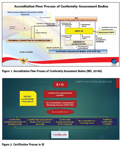
In article 56 of Act Nr.4 / 2011, BIG was mandated to carry out the accreditation of independent institutions or agencies related GI conformity assessment, while for certification activities carried out by institutions that have received a certificate of accreditation or appointed by the BIG. BIG establishes chief regulation Nr. 11/2013 on the System of Certification in the field of Geospatial Information, enhanced by chief regulation Nr. 1/2014. The scope of the accreditation process conducted by the BIG consisting of accreditation to institutions related professionals certification, service providers and training institutes/ courses; initiated the establishment of the Geospatial Information Service Development Agency (LPJIG) assigned to assist BIG in developing of the geospatial information services; and the scope of accreditation conducted by LPJIG covers the accreditation of conformity assessment bodies (CAB) related professionals, service providers, instrumentation, and geospatial information products, as well as training institutions and courses.
In order the accreditation which is issued by BIG recognized by the international community, BIG in collaboration with the National Accreditation Committee (KAN) in carrying out accreditation. In Act Nr. 20/2014 on Standardization and Conformity Assessment, KAN is the only institution given the authority to provide accreditation services conformity assessment institutions (laboratories, inspection bodies, certification bodies) in Indonesia. KAN has gained international recognition MRA/MLA in APLAC (Asia Pacific Laboratory Accreditation Cooperation), ILAC (International Laboratory Accreditation Cooperation), PAC (Pacific Accreditation Cooperation) and IAF (International Accreditation Forum). Collaboration between the two agencies was later formalized on the letter of agreement between BIG with the KAN Nr. B-8.1/KA/PK/4/2016 and Nr. 008/ BSN/MOU/IV/2016 on Implementation of GI Accreditation on April 8, 2016.
National policy of streamlining the government organizational structure in 2015 led to LPJIG not been able to carry out its duties and functions. In order to conformity assessment activities keep running, BIG formed the GI Conformity Assessment Working Group (KKPK IG) through the chief regulation Nr. 1/2016 on conformity assessment system which is enhanced through chief regulation Nr. 10/2016. On January 28, 2016 KKPK IG was formed in the field of Geospatial Information with representatives from academia, business, associations and government. This working group established under Head of Geospatial Information Agency decree Nr. 3/2016 on KKPK IG.
The document product of KKPK IG in 2017 are 1) Guidelines for Accreditation of Geospatial Information Competency Training Institutions, 2) Chief Regulation Nr. 4/2017 regarding the Procedure for Certification of Professionals in the field of Geospatial Information, 3) Decree of Chief Nr. 21.3/2017 regarding Standards Test Requirements for Certification of Professionals in the field of Geospatial Information, 4) Decree of Chief Nr. 27/2017 regarding Classification and Qualification as Service Provider in the field of Geospatial Information, 5) Document of Standard Competency Practice in Geospatial Information Sector, including sub-field of Terrestrial Surveys, Hydrography surveys, Photogrammetry survey, Cartography, Remote Sensing, Geographic Information System, and Regional Surveys, 6) Evaluation Guidelines and Guidelines for Geospatial Information Product Certification (Quality Assessment Guidelines for The Education Atlas), 7) Two Conformity Assessment Bodies (LPK) in the Geospatial Information sector have been accredited and 3 LPKs in the accreditation process at the end of 2017.
Development of Accreditation and Certification
Accreditation is granted formal recognition by the accreditation body of the competence of an institution or organization in doing particular conformity assessment activities. Certification is a statement of suitability from third parties related to products, processes, management systems or personal to a particular standard. Before conducting a accreditation and certification, accreditation assessors trained on: 1) deepening of ISO/IEC 17011:2011 conformity assessment – general requirements for accreditation bodies accrediting conformity assessment bodies; 2) ISO/ IEC 17067: 2013 conformity assessment – fundamentals of product certification and guidelines for product certification schemes; 3) documents of quality KAN; 4) management system requirements in SNI ISO/IEC 17065:2012 (conformity assessment – requirements for bodies certifying products, processes and services) and SNI ISO/IEC 17024:2012 (conformity assessment – general requirements for bodies operating certification of persons); 5) ISO 19011: 2012 – standard for auditing management systems.
Guideline document for accreditation of GI conformity assessment body is used as a reference in the proposal of accreditation on conformity assessment body of professionals and GI services provider. The guidelines which published by the BIG is a reference in determining the general requirements for BIG to accredit CABs.
Guidelines for Accreditation of Conformity Assessment adopted from SNI ISO/IEC 17065:2012 on conformity assessment – requirements for bodies certifying products, processes and services and SNI ISO/IEC 17024:2012 on conformity assessment – general requirements for bodies operating certification of persons.
Accreditation to the CAB Professionals aims to: 1) improve the quality of GI conducted by professionals; 2) protect government agencies, local authorities, and everyone from improper GI implementation and inadequate with GI standards; and 3) improve the certainty, fluency, and efficiency of the GI implementation. Before taking the accreditation, accreditation process need to be known and be understood by applicant. On KAN website, there are accreditation information and criteria, preliminary visit, accreditation application (KAN only responds CABs that submit formal application for accreditation, which is signed by authorized representative of the CABs), contract review, sub-contract for assessment, preparation for assessment, adequacy audit, on-site assessment, analysis of assessment findings and report, surveillance and reassessment, witness of CAB performance, extending scope of accreditation, proficiency testing (for laboratories and inspection bodies), decision making and granting accreditation, suspending, withdrawing and reducing accreditation scope, which should be followed properly and prepared by the applicant.
Accreditation is still ongoing in the beginning 2017, but now, two conformity assessment bodies (LPK) in the Geospatial Information sector have been accredited and 3 LPKs in the accreditation process at the end of 2017. This means GI professional certification can be monitored from the quality and quantity. GI certification system is based on SKKNI and certification system will be harmonized with the ASEAN MRA on surveying certification system. BIG has a big dream to GI One Certificate Policy Program. This is a future challenge, how to unite the professional certification system in the field of GI for various sectors. Intersector certification system nowadays that is currently running, still requires regulation as mutual recognition, so it makes more efficient, scalable, and traceable in accordance with the professional standards of IG, nationally and internationally.
Acknowledgement
We would like to thank our colleagues in Center for Standardization and Institutional of Geospatial Information especially standard team, human resource and GI Industry team, member of the formulator team SKKNI and KKNI IG, and KKPK IG, for their contribution in GI development.
References
Amhar, Fahmi, et al. 2016. Projection of Geospatial Human Resources in Indonesia until 2025. FIG Working Week 2016
ASEAN Secretariat. 2015. Handbook on Liberalisation of Professional Services through Mutual Recognition in ASEAN: Surveying Services. Jakarta
Badan Informasi Geospasial. 2016a. Katalog Standar Nasional Indonesia Penyelenggaraan Informasi Geospasial (Indonesian National Standard Catalog – Implementation of Geospatial Information)
Badan Informasi Geospasial. 2016b. Laporan Akhir Kegiatan Kelompok Kerja Penilaian Kesesuaian (Final Report of the Conformity Assessment Working Group)
International Organization for Standardization. 2014. ISO/ TR 19122:2004 Technical Report Geographic information/ Geomatics: Qualification and certification of personel;
Kementerian Hukum dan HAM. 2011. Undang-Undang Republik Indonesia No. 4 Tahun 2011 tentang Informasi Geospasial (Act Number 4 year 2011 on Geospatial Information)
Kementerian Hukum dan HAM. 2014. Undang-Undang Republik Indonesia No. 20 Tahun 2014 tentang Standardisasi dan Penilaian Kesesuaian (Act Number 20 year 2014 on Standardization and Conformity Assessment).
Komite Akreditasi Nasional. 2017. Accreditation Process – Accreditation Information and Criteria. http://www. kan.or.id/?page_id=93&lang=en
Ministry of Finance Republic of Indonesia. 2015. Government Preparing Regulation of Acceleration of Implementation of One Map Policy. http://www. kemenkeu.go.id/en/Berita/ government-preparing-regulationacceleration- implementation-onemap- policy%3Ftag%3 Dpaket
Narieswari, L. and Sumaryono. 2016. Indonesia’s Experience in Developing Geospatial Professional Competency Standard. FIG Working Week 2016
Republic of Indonesia. 2014. Buku II Agenda Pembangunan Bidang – Rencana Pembangunan Jangka Menengah Nasional (RPJMN) 2015-2019 (National Medium-Term Development Plan from 2015 to 2019) http://www.bpkp.go.id/public/ upload/unit/sesma/files/Buku%20 II%20RPJMN%202015-2019.pdf
Shahab, Nabiha. 2016. 2016. Indonesia: One Map Policy. 1st Edition Open Government Partnership http:// www.opengovpartnership.org/ sites/default/files/case-study_ Indonesia_One-Map-Policy.pdf
Silalahi, Florence Elfriede S. and Annacletus Ari Dartoyo. 2015. Potensi Kebutuhan Standar Bidang Informasi Geospasial di Indonesia (Potential Need for Standards on Geospatial Information Sector in Indonesia)
The Institution of Surveyors, Australia. National Competency Standards for Professional Surveyors. 1st edition July 1996.


 (No Ratings Yet)


Leave your response!