| Surveying | |
Improving cadastral survey procedures using crowd sourcing techniques
Volunteered Geographic Information (VGi) was first introduced as a term by Goodchild (2007), who presented the Volunteered Geographic Information as an individual effort of amateurs who act voluntarily in GIS collection, editing and manipulation and their results may or may not be accurate. The main goal of the new phenomenon is the participation of the citizens. Everyone can be involved by collecting and uploading data or by editing entries and monitoring the results. Different terms are interlinked to it; User Generated Content, Crowdsourcing and Neogeography are only a few of them share the main philosophy. It is clear that a new era has risen in geographic information science by the citizens’ involvement. VGitechniques were first used for navigation purposes and leisurely activities due to the high cost of conventional maps and the restrictions towards their use. However, the phenomenon was quickly extended in crisis management. Haitiearthquake and Hurricane Katrina are two representative examples of VGimapping, which meant that supplies in medicine and food were provided in short time. Pultar et al., (2009) were among the first who noticed that dynamic GIS is an ideal tool for storing, analyzing and visualizing natural disasters such as hurricanes, wildfires and earthquakes. Slum mapping and mapping of virgin areas was also developed with the aid of VGi. World Bank supported South Sudan mapping and numerous other applications which are carried out worldwide. Land administration consists the basic tool for a proper land management; guarantee of ownership and security of tenure, fair taxation, security for credit, development of land markets, protection of land recourses, facilitation of State-owned land, reduction of land disputes, facilitation of rural land reform and improvement of urban planning (UNECE, 2005). It is remarkable that the number of megacities has risen from two in 1950 to 20 in 2005, while 17 of them are located in the world’s less developed regions (Doytsher et al., 2010). More than 1.1 billion people live in slums which are located to unregistered parcels (McLaren, 2011). It is clear that the procedures should quicken and the cost should be in low levels with the involvement of individuals. As Adlington (2011) has underlined in East Central Asia region, the World Bank Land Administration and Management projects have succeeded the greatest land reform the world has ever seen because they have been guided by surveyors who were open to help without being stuck to traditional methods and high levels of accuracy, and they were willing to be practical and meet the needs of the society. Social media & crowdsourced technology may provide transparent land administration in places where corruption & inefficiency is endemic, if used with an understanding of errors, accuracies & usefulness of various forms of spatial information. It is clear that society’s needs for easy editable and inexpensive maps which can be produced in short time have involved VGiin various fields. Is land management, which mainly applies land information to land resources (UNECE, 2005) between the fields that can flourish with the aid of VGi? Can legal principles and strict regulations be bypassed? Can sensitive personal information be trusted to volunteers? Is accuracy the most important part of a cadastre and how it can be achieved? The research community has to identify VGi’s opportunities and limits. The hellenic cadastreProgress and Statistics The Hellenic Cadastre started its operation in 1995. Although the project is in progress for 17 years, the results in some regions are quite disappointing concerning progress and efficiency. It affects an area of 132,000 km2 and 37,200,000 property rights of 11,000,000 people approximately. However, only 6.4% of the total area has been completed until now, which means that 8,400 km2 and 6,800,000 property rights (which in percentage is 17%) have been officially recorded. The total cost of the project has reached 340 M€. Nowadays, 3,100 km2 of the total area and 7,500,000 property rights approximately are under compilation. The cost of the new cadastral survey is estimated to 212 M€, not including VAT, and the amount of the new registered rights approaches 42 M€. The remaining 120,500 km2 and 22,900,000 rights, concerning mainly rural areas, are still unregistered. Processes The process of a cadastral record is summarized in the following steps. At first, the declarations of the property owners are submitted to the Cadastral Survey Offices and the registration of the declared rights is introduced in a digital database. Owners are also expected to recognize their properties on orthophotos, although the process is not characterized as successful in rural areas. Secondly, the interim cadastral tables and diagrams are formed based on the data that has been collected from the submitted declarations which means that an objection period starts by the suspension of the interim cadastral data at the Cadastral Survey Offices for a twomonth period. Meanwhile, dispatch of extracts is sent to the right holders for their information and acceptance. The objections or applications for correction of a cadastral registration are submitted and forwarded to independent administrative committees, depending on the case, by whoever has a legal right. Then, the cadastral data is reformed and the final cadastral tables and diagrams are revised. These registrations are called Initial Registrations and they constitute the first registration in the Hellenic cadastre (Hellenic Cadastre, 2011). Identified errors – Three representative examples
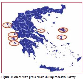
More precisely, there are four categories of errors which affect the areas mentioned below: 1. Land parcels whose shape or boundaries need correction 2. Land parcels which although they were declared by the owners within the declaration period, they were not recorded by the contractor in the interim cadastral plans. Hence, these were not recorded at all. 3. Land parcels which were registered into the interim cadastral plans in wrong cadastral units 4. Land parcels which are located in adjacent cadastral units and are affected geometrically due to the correction of the boundaries of the unit and are under re-survey Lesvos Island Lesvos is among the areas where gross errors have been recorded during the objection period. Near 42,205 land parcels have been registered until now and is still unknown how many land parcels have been recorded wrongly as the cadastral survey is still under the editing process. More than 2,500 objections have been submitted until now. It is estimated that if the percentage reaches 30% (aprox. 12,000 land parcels) the cadastral surveys will be repeated. Chios Island
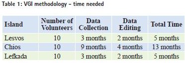
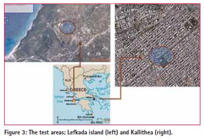
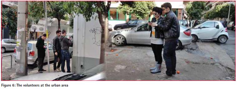
Chios is in a similar situation to Lesvos. Almost 113,400 land parcels have been recorded until now, while 1,970 errors have been mentioned. The policy is the same; if the recorded errors are more than 34,020 the procedure should be repeated. Lefkada IslandLefkada was affected in two different cadastral areas mainly; Tsoukalades and Haniotes village which are both mountainous and are located to the hinterland of the island. Tsoukalades was selected by the research team as the ideal area where the first practical experiment took place (Basiouka & Potsiou, 2012). The research team came in contact with the local authorities of the village and asked for their participation. In their turn, local authorities asked among the property owners for volunteers. The process and the results were analyzed in the next chapter. It is estimated that 43,440 land parcels were recorded in total, while 790 errors have been found till now. The exact cost and time for the process to be repeated is not known yet as the objection period has not come to an end and the number of gross errors has not been identified in detail. However, the new cadastral survey is expected to last a year for the declaration collection and two years for the processing based on past experience. VGI methodology – A rough estimation for an alternative process A rough estimation of the VGimethodology as an alternative way to correct the gross errors indicated that the time and cost can be minimized. According to the assumptions of the estimation, 10 volunteers should participate and record 15 parcels per day. This estimation is based on the results derived by the first practical experiment which was carried out by the research team in Lefkada Island. The results showed that the scattered areas in Chios can be resurveyed in nine months and data editing can be concluded in four months. The whole process does not exceed 13 months in total in an island which seems to confront the greater problem. The errors in Lesvos can be corrected with the same process within five months. The cadastral surveys may be held with the aid of undergraduate technical university students as team leaders. Similar role may be also kept by the local authorities who may provide the volunteers with the needed equipment and support on technical issues. It is clear that the whole process is based on what Goodchild (2008) mentioned in his research; “Residents of a neighborhood are inherently experts in the local area.” The results are summarized in Table 1. The second step includes data uploading by volunteers and the third includes map editing. The local residents supported by the young team leaders will be able to edit the collected nodes and create polygons by using open source systems. The attribute data which will accompany the geographical data will be registered by the volunteers at the forth step of the procedure and the result will be shown at the last step. The practical experiments – crowd sourcing in cadastreThe two practical experiments were carried out in different time periods and areas covering different methodologies of VGi. The aim of the experiments was to simplify the processes needed for a cadastral survey, and to reduce time and cost. Although the concept behind the two experiments was the same, the process was different. The first experiment was carried out in a rural area at Lefkada Island and the second in an urban area in the city of Athens. The results of the first practical experiment were presented at the FIG Commission 3 Workshop and were published (Basiouka & Potsiou, 2012). The test areas The first experiment was carried out in Lefkada Island, an island of the Ionian Sea. It lies between the islands of Corfu and Kefalonia. It is very close to the shores of the western mainland of Greece covering an area of 302.5 km2 and is fourth in size in the Ioanian islands complex, with a population of 23,000 people. The community of Tsoukalades is one among seven communities part of the municipality of Lefkada. Tsoukalades village is located 220 m above sea level in the north-west part of the island and it has 430 habitants according to the last census. The second experiment was carried out in the city of Athens at the area of Kallithea, which is expanded between Athens and Faliro Bay. Municipality of Kallithea is an urban area at the south east part of Athens and it has more than 200,000 habitants. The first area was under cadastral survey for more than 12 years due to the errors and the specific cadastral unit which has been resurveyed four times. The cadastral survey at the second area of interest which is an urban area with well defined boundaries has not yet been finished. The experiments Rural area – Lefkada IslandThe first experiment took place at Lefkada Island during a summer weekend of 2011. Fifteen volunteers participated and 19 land parcels were traced with the aid of three experts and a handheld GPS. The area of interest is a rural one with olive trees and cultivated areas. The parcels were chosen randomly so that the sample will berepresentative and the land owners volunteered to collect the tracks of their boundaries with the aid of a handheld GPS (figure 4). The data editing was done later at the laboratory by the research team. The results indicated that the location and shape of all land parcels compared to the last official cadastral survey are correctly defined and the majority of the land parcels’ area size is sufficiently defined and within the AAA requirements posed by the KTIMATOLOGIO SA. Only eight of the hundred measured nodes have coordinate deviations greater than 5m, while the area size of seven out of the nineteen land parcels (37%) differentiated from the correct size more than the required accuracy. Urban area – KallitheaThe second test took place at Kallithea Municipality, close to the centre of Athens, in a one day application during the winter 2012. Nine volunteers participated, seven land parcels were traced, one handheld GPS and iPad were used. The results using the handheld GPS were disappointing compared to the technical specifications required by the official mapping agent. Due to signal obstacles, the accuracy was not satisfactory so a different approach was applied. The land parcels were drawn online on orthophotos provided by KTIMATOLOGIO with the aid of iPad (figure 6). The volunteers used the online web system which is supported by the official mapping agent (KTIMATOLOGIO SA) and created the interim cadastral map extract of their building on orthophotos (figure 5). The orthophotos which are provided by the system were received between 2007 and 2009, and their accuracy approaches 20 cm in urban areas and 50 cm in rural areas. Each extract was accompanied by the parcel’s coordinates and total area which could be used comparatively in a further step of the process as a control. The whole process was straightforward and offered the opportunity to local residents to conclude the process from data editing to map rendering. The results were in high levels of accuracy. The volunteers ConclusionsThe applied methodology, offered satisfactory results in both cases and within the technical specifications required by KTIMATOLOGIO. The participation was enormous and time was eliminated dramatically without taking into account the cost. The volunteers were willing to participate, answer the questions and get involved in the experiment. The involvement of local authorities in the first experiment and undergraduate students in the second one guaranteed the process and help to overcome technical issues.
AcknowledgementsAcknowledgements and thanks to the Municipality of Lefkada, Irene Stamatelou, President of the Community of Tsoukalades for providing support and help to the implementation of the case study, Ktimatologio S.A. for providing the cadastral surveys at “Tsoukalades” community, and all volunteers for their participation. Special thanks to Prof C. Ioannidis, chair of FIG Com3 WG 3.2 for his guidance and contribution and to S. Soile, Surveyor Engineer at the Laboratory of Photogrammetry of NTUA for her technical support and K. Apostolopoulos, undergraduate student of NTUA who helped in the implementation of the second experiment. ReferencesAdlington, G., 2011. “Rise or Fall of the Cadastre Empire?, Proceedings of FIG International Symposium Cadastre 2.0, Innsbruck, 30 September 2011. Ather, A., 2009. “A Quality Analysis of OpenStreetMap data”, MEng Thesis, London, University College London. Basiouka, S., 2009. “Evaluation of the OpenStreetMap quality”, MSc Thesis, London, University College of London. Basiouka, S and Potsiou, C., 2012. “VGiin Cadastre: a Greek experiment to investigate the potential of crowd sourcing techniques in Cadastral Mapping”. Survey Review, vol. 44 (325), April, 2012, pp. 153-161(9). Domi, 2005. Encyclopedia “DOMi”, vol 29, p. 407, Athens, Greece. Doytsher, Y., Kelly, P., Khouri, R., McLaren, R., Mueller, H., Potsiou, C. 2010. “Rapid Urbanization and Mega Cities: The need for Spatial Information Management”, International Federation of Surveyors, Publication No 48, Denmark, pp. 1–91. Goodchild M.F. 2007. “Citizens as sensors: the world of volunteered geography”. GeoJournal, 69(4):211-221. Goodchild, M., 2008. “Commentary: whither VGi?”. GeoJournal, 72:239-244 Haklay, M., 2008. “How good is OpenStreetMap information? A comparative study of OpenStreetMap and Ordnance Survey datasets for London and the rest of England”. Under review in Environment & Planning B. McLaren, R., 2011. “Crowdsourcing Support of Land Administration”. RICS, London. p. 32. Laarakker, P., de Vries, W.T., 2011. “www.opencadastre.org: exploring potential avenues and concerns” Proceedings of the FIG Working Week 2011, Marrakech, Morocco, p. 16. Papadopoulou, E., 2010. “Massive corrections of initial cadastral registration”, Seminar on the Hellenic Cadastre, Technical Chamber of Greece-Branch of central Macedonia, Thessaloniki, April 2010. Pultar, E., Raubal, M., Cova, T., Goodchild, M., 2009. “Dynamic GIS Case Studies: Wildfire Evacuation and Volunteered Geographic Information”. Transactions in GIS, 13(1): 85-104 United Nations Economic Commission for Europe., 2005. “Land Administration in the UNECE region. Development trends and main principles.” New York & Geneva, p. 104. Zimmermann, W., 2011. Private correspondence. In: McLaren, R., 2011. “Crowdsourcing Support of Land Administration”. RICS, London. p. 32. Online resourcesHellenic Cadastre, 2011a. Cadastral Survey [online]. Available at http:// www.ktimatologio.gr/ktima/EN/index. php?ID=MpuNFMi98NlPs1QZ_ EN (accessed August 2011). Hellenic Cadastre, 2011c. Orthophotos [online]. Available at http://gis. ktimanet.gr/wms/ktbasemap/default. aspx (accessed August 2011). Municipality of Kallithea, 2012 Municipality of Kallithea [online]. Available at http://www.kallithea.gr/ Default.aspx?pid=5&la=1(accessed February 2012). Prefecture of Lefkada, 2011. Municipality of Lefkada [online]. Available at www. lefkada.gr (accessed August 2011).
|


 (132 votes, average: 1.09 out of 5)


Leave your response!