| Policy | |
Government policy, applied research, commercialization…
|
Dr. Robert A. Ryerson, Chanchai Peanvijarnpong
|
||||||||||||||||||||
|
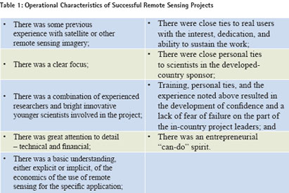
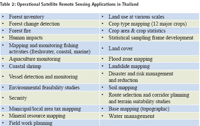
What is especially interesting in the Thai case is that Thailand has long had a low-cost/high volume remote sensing data policy as was recommended for geospatial data in Canada. Furthermore it has not had to significantly modify its policies either for international data or for THEOS data to conform to best practices related to increasing use or to The Government of Thailand made the decision to subsidize the acquisition of remotely sensed data to ensure that the country could derive the full downstream public-good benefits that are associated Low cost leads to high use and high benefitsInterviews were conducted with officials involved in the management and use of remote sensing data in a number of government agencies responsible for forestry, parks, land use, agricultural economics, fisheries, hydro-electric powergeneration and distribution, narcotics control, hydrology, defense, mineral resources, and municipal government. Satellite data are currently being used for all of these applications on an operational and on-going basis. Many applications can be directly linked to important government policies in Thailand and elsewhere – including the Millennium Goals. Equally important, if the agencies involved had to pay the socalled “commercial rate” for data, our To put the data use within Thailand into a more international context, consider that over 4000 images are provided annually by GISTDA. Given the size of Thailand and the size of Canada, this rate of use would be the same as Canada’s governments (federal and provincial) using 77,600 images. Even counting the use of Radarsat imagery Of those interviewed in the key Thai user agencies all had an on-going need for the information obtainable from satellite data. Most had some level of in-house research or applications development capacity – often tied to university researchers, and in a few cases (such as fisheries) with international development assistance. Technology transfer from these applications development efforts was also an on-going activity. In some agencies as many as 70-100 people were users of the data, while in others it was fewer than twenty. In virtually all of the agencies interviewed the operational requirements to achieve success noted above were met. In some cases such as forestry, the monitoring has been on-going for as long as thirty years. In others data use on an on-going and operational basis was a new activity that came as a direct result of the lowering of data costs. As one senior Thai resource management official said “the lower price motivates the government user where cost – and not profit – is the controlling factor.” This sort of comment was repeated again and again. Low data cost was cited as a primaryreason to use the data to the extent that they now do for each and every agency. The approval of THEOS by the Government of Thailand is a strong endorsement and statement on the value of remote sensing data to the country. General application of the price modelWhile this finding is especially important in less developed countries, it is also important and can be transferred for application to developed countries. The United States has examined several models for data delivery – and seems to have settled on a combination of commercial for high resolution data and COFUR for satellite data for the derivation of public good information. Europe seems to have opted for a similar blend, although the emphasis within the European Space Agency as well as within some national space agencies seemed to be geared more towards the widespread distribution of lower cost data to ensure that the public good benefits are derived. India has also worked hard to get data into users’ hands to derive these same benefits. (Radhakrishnan, 1999.) It is worth noting that a number of authors have stated that one of those benefits is the creation of a robust industry to interpret the large volumes of data that are consumed under the low-price/high-volume model. France and Canada seem to be among the few advocating the commercial sale of data at commercial rates by commercial entities from what began as (and in some cases still are) nationally subsidized systems. It is worth noting that at a meeting on Radarsat-2 Canadian Space Agency staff suggested that the follow-on radar constellation will not be distributed commercially, but rather will be provided by government – which we assume means at a lower price. With each shift in data policy and/or level of competition one can observe a shift in the development of industry, as well as in the application of the data as several previous studies cited in the references below have shown. ConclusionData cost has been a limiting factor in achieving the full benefits of remote sensing in both developed and developing countries. The approach developed by Thailand to data cost and other elements of data policy, research, and the emphasis on technology transfer have together resulted in a vibrant user community in government using far more data for far more applications on a comparative basis than many other countries in the world – including so-called developed countries. Thailand’s extensive use and derivation of benefits of remote sensing across government provides a clear demonstration of both the impact and importance of both an informed data policy and the use of “home grown” applied research. ReferencesRadhakrishnan, K., 1999. Some Strategies for the Management of the Indian Earth Observation System. Ph.D. Thesis. Dept. of Industrial Engineering and Management, Indian Institute of Technology, Kharagpur, India. 2) Ryerson, R.A. and E. Quiroga, 2000. Taking Remote Sensing from Development Projects to Operational Use: Some Common Attributes of Successful Projects. Session Keynote Paper. Geo Asia Pacific Conference, Bangkok, Thailand, October 2000. 3) Ryerson, R.A., 2005. Making Remote Sensing Operational: A Changing World Requiring Changing Approaches to Data Policy. Invited Key-note Paper. |
||||||||||||||||||||
|
||||||||||||||||||||
|
Pages: 1 2


 (No Ratings Yet)


