| GNSS News | |
GNSS
Measuring water levels with cm-level accuracy using GNSS-IR
Researchers at the Institute of Geodesy and Geoinformation at the University of Bonn, led by Dr. Makan Karegar, have transferred water -level monitoring technology from the Rhine to Africa, Australia, and the Philippines as part of ESA projects. Originally developed in the DFG Collaborative Research Center SFB 1502 (DETECT), the technology enables continuous, freely accessible monitoring of inland and coastal waters in data-poor regions worldwide.
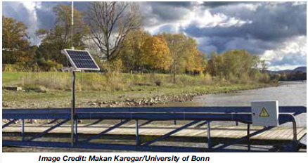
The technological centerpiece is the Raspberry Pi Reflector (RPR), a compact, solar-powered sensor developed at the University of Bonn. Using Global Navigation Satellite System Interferometric Reflectometry (GNSS-IR), it measures water levels with centimeter-level accuracy (https:// www.uni-bonn.de/en/news/272-2022).
Only a portion of the signals emitted by the GNSS satellites is directly captured by the antenna. The rest is reflected by the water surface and reaches the receiver via this detour. When superimposed with the directly received signal, it forms specific patterns known as interference patterns. These can be used to calculate the distance from the antenna to the water surface.
The CAMEO-WAGST project (“Cameroon Advanced Measurements for Enhanced Observations of Water levels using Affordable GNSS-IR and Sentinel-3 & 6 Technology”) has established the first dedicated GNSS-IR network for monitoring water levels along coasts and rivers in Camroon and was funded by the European Space Agency (ESA). Between May and June 2025, researchers, in collaboration with Dr. Loudi Yap, director of the Research Laboratory in Geodesy at the National Institute of Cartography, installed eight RPR sensors in Cameroon—two on the Sanaga River and six along the coast. “A lack of infrastructure for reliable hydrological and coastal monitoring in Cameroon has so far hindered effective flood risk management and early warning systems,” said Yap.
This collaboration, under the umbrella of the EO Africa Research and Development Facility, is already bearing fruit, says Dr. Roelof Rietbroek, research coordinator at ESA’s EO Africa R&D Facility. “We hope this paves the way for more reliable monitoring of flood-prone regions in Africa.”
Building on this success, the follow-up project St3TART-FO was launched in collaboration with the European Space Agency. A total of 17 RPR sensors will be installed in seven countries, including West Africa, Australia, and the Philippines. “The goal is to create a freely accessible reference measurement network for calibrating satellite data,” says Karegar. For the first time, the network will provide continuous water-level data at previously unmonitored locations.
The collaboration is based on years of scientific exchange between Africa and Europe. Partners include the International Institute for Water and Environmental Engineering (2iE) in Burkina Faso, the National Institute of Cartography in Cameroon, Ghana’s Environmental Protection Authority (EPA), the Nigeria Hydrological Services Agency (NiHSA) and the University of Maiduguri in Nigeria, Assane Seck University of Ziguinchor in Senegal, the University of Southern Queensland in Australia, and the University of the Philippines Diliman. www.uni-bonn.de
Protect civil aircraft in conflict zones say UN aviation chief
The International Civil Aviation Organization (ICAO) is calling for stronger measures to protect civilian aircraft from military threats, revealing that the risk of weapons targeting civilian planes grows worldwide.
ICAO Secretary General Juan Carlos Salazar informed delegates at the 2026 World Overflight Risk Conference in Vallarta, Malta, that emerging military technologies—including long-range weapons systems, unmanned aircraft systems (UAS), global navigation satellite system radio frequency interference, and advanced air defence systems—pose risks to civilian aviation. While praising the aviation industry’s ability to reroute flights and maintain operations during the recent Middle East crisis, Salazar stressed that operational flexibility alone cannot address the fundamental security threat posed by weapons systems.
Salazar commended States and airspace users for the measures implemented to mitigate the safety and security risks posed due to the escalated situation in the Middle East. He noted that more than 10 States had partially or fully closed their airspace, which also significantly impacted international air transport. He pointed to ICAO Assembly Resolution A42-4 and Article 3 bis of the Chicago Convention, which explicitly prohibits the use of weapons against civilian aircraft, as the legal foundation for demanding better protection. However, he acknowledged that international law alone has proven insufficient as regional conflicts intensify.
ICAO is finalizing a Global Crisis Management Framework to coordinate responses when civilian aviation faces threats, but Salazar emphasized that this reactive framework must be paired with proactive measures to prevent attacks on civilian aircraft. www.icao.int


 (No Ratings Yet)


Leave your response!