| GNSS | |
GAARDIAN: A system to detect GNSS jamming and Interference
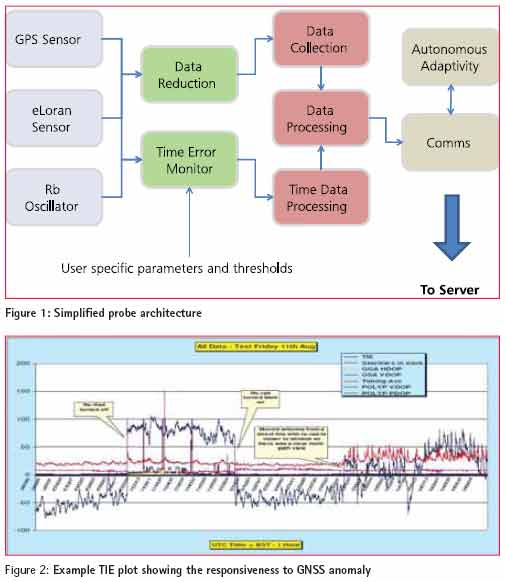
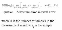
GNSS vulnerability currently one of the most talked about topic in the GNSS world. Publicity of events such as the “accidental” GPS jamming at the Newark Airport in the United States, the Royal Academy of Engineering report regarding the vulnerability of UK GNSS services, the recent investigations into the LightSquared “problem,” numerous conference presentations, and many articles in technical journals and news media — all address the well-known fact that space-based position, navigation, and timing (PNT) is vulnerable to localized RF interference at or near to the receiver operating frequency. Some of this publicity relates to the UK’s developments in the area of detecting GNSS interference, specifically the GAARDIAN program (for GNSS Availability, Accuracy, Reliability anD Integrity Assessment for Timing and Navigation). This was a wide collaboration between government, academia, and industry to develop a robust system for analyzing interference phenomena associated with GPS and eLoran systems and the effects on their use in safetyand mission-critical applications. The GAARDIAN program completed in 2011. This article gives an overview of the resulting capability to detect GNSS interference and jamming. It also provides details about a specific recent detection event that demonstrated the capability of the system and that, by involving UK Law enforcement agencies, proved the system can be operationally effective. GAARDIAN’s GuardiansGAARDIAN, a collaboration led by Chronos Technology Ltd., included the University of Bath, General Lighthouse Authorities of UK and Ireland, BT, Ordnance Survey, National Physical Laboratory, and Imperial College London. The project was part-funded by the UK’s national innovation agency, the Technology Strategy Board, and ran between October 2008 and March 2011. The project set out to create interference detection and monitoring sensors (IDMs) that could be deployed in the vicinity of safety- and/or missioncritical PNT applications. These sensors or probes had a design brief to monitor the integrity, reliability, continuity, and accuracy of the locally received GPS and eLoran signals on a roundthe- clock basis and report back to a central server, which acts as the user interface. Users were to be alerted in real time to any anomalous behaviour in either of the GPS and eLoran signals. This concept can also be considered a GNSS/PNT quality of service (QoS) monitoring and reporting system. System designThe GAARDIAN program has resulted in a 24×7 nationwide experimental IDM system, whose sensors continuously monitor PNT signals from both GPS and eLoran. GPS is the main GNSS technology monitored, but integration of other GNSS technologies is certainly possible. eLoran is an alternative PNT technology unaffected by interference to GPS and technically dissimilar in its dependencies, e.g., operating at different frequencies and using separate infrastructure from GNSS. The server offers the users real-time access to the output of the probes (including anomalous events) and dedicated system (GPS and eLoran) positioning/ timing performance. Furthermore, it provides the probes with information on failures that have a regional impact. Both the probes and the server integrated specialist monitoring technologies from the partners, with the integration and normalization being carried out at and by Chronos’ UK headquarters premises and staff, respectively. The probe is designed to be adaptable to various user applications, and specific functionality can be enabled or disabled depending on user requirements. Every probe performs a minimum set of functions: • interference detection • failure identification • data capture during anomalous events • eLoran validation The specific functionality of the probes and the server, summarised above are based on these activities. For example, assessment of conditions such as space segment f ailures can be performed to ensure an event is due to a localized problem and not systematic. Figure 1 outlines the basic probe architecture in which the outputs from a GPS receiver, an eLoran receiver, and a small form factor rubidium atomic clock are analyzed. One form of the analysis performed is an investigation of the 1PPS output of the two PNT sources against a common reference. A time interval error (TIE) measurement of these outputs is conducted continuously over multiple sample window sizes. This is converted to maximum time interval error (MTIE) and compared with a predefined limit. This enables short-, medium-, and long-term timing anomalies to be reported. Not only does this feature enable the detection of multipath, interference, and system anomalies in the GPS signal, it also provides a readymade QoS service should eLoran become the accepted technological alternative PNT to GPS or for adopters of the future Galileo Publicly Regulated Service (PRS). Maximum time interval error (MTIE) is the largest peak-to-peak TIE (i.e., wander) in any observation interval of length t, calculated as follows:
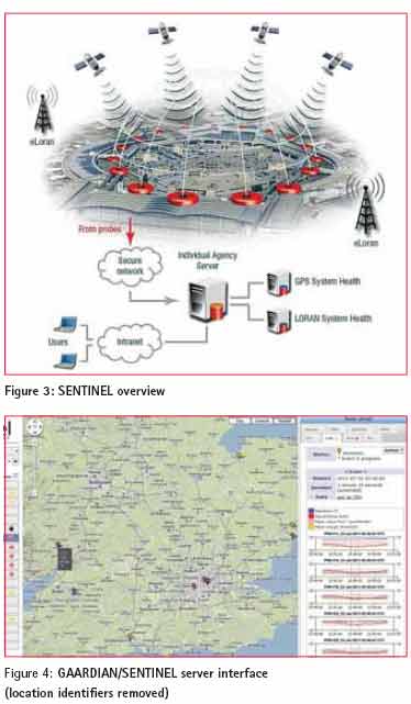
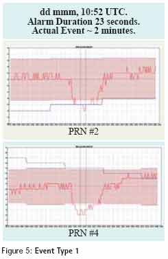
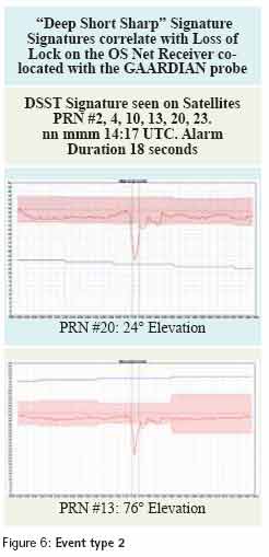
interval, N is the number of samples in the data set. The index variable iis incremented to scan across the window and k, representing the starting point of the current data set, is incremented for sliding the measurement window. This principle can be used to set thresholds of maximum allowable TIE, which when exceeded can be fl agged as an alert. Figure 2 shows some early experimental data that compares a GPS 1PPS to a cesium standard, with a jump in the TIE when a system anomaly occurs. In the example data, the operation of a GPS repeater is causing the reaction. In addition to this TIE measurement, the probe characterizes the GNSS RF multipath environment. This is accomplished via an algorithmic comparison of the measured GPS signal/noise ratio (SNR) for each satellite against a pre-calculated polynomial “Quickthresh” mask. This algorithm uses the SNR, azimuth, and elevation values to develop a mask for “normal” signal strength and extract some parameters related to multipath of the probe. An “event” occurs when the SNR for a [userconfigurable] number of satellites has dropped below expected tolerances, leading to the assumption that a multipath or jamming environment may exist. Other parameters are taken into account, such as standard deviation per satellite and the multipath conditions of the “normal” state. This means that a probe can, if necessary, be deployed into a strong multipath environment. Over the course of the GAARDIAN program, the time required for the normal state determination was reduced to a level that enables the rapid deployment of a probe to a location of interest, a concept being used in the successor program, SENTINEL (Figure 3). Probes are currently deployed at various locations around the UK and Ireland and continuously report on the integrity, continuity, accuracy, and reliability of the PNT signals in the vicinity. The data is communicated back to a central location, and continuously available via a common web browser, making the complex data accessible quickly and easily. Figure 4 shows the server’s graphical user interface through which users are alerted and, in turn, can access data from individual probes and perform detailed event analysis. Server side analysis tools include the ability to perform historical trend analysis of both the GPS and eLoran data from the probes. These tools enable operators and users to monitor long-term factors, such as the eLoran additional secondary factor (ASF) variations, and analyze long-term GPS QoS metrics and event patterns. This pattern analysis capability was used during a recent investigation by the GAARDIAN program team, which we will describe next. Event investigationGAARDIAN as a research tool has delivered a number of key firsts in the field of GPS interference detection, eLoran monitoring techniques, and GPS multipath characterization, Even though only an experimental rather than operational system, one of the partners, Ordnance Survey, requested that a GAARDIAN probe be moved to a specific site of interest in the UK. This article will not detail the location of this probe, but the reason for the deployment was that an Ordnance Survey OS Net reference station at the location was experiencing significant failures. The OS Net network, consisting of more than 100 continuously operating GNSS receivers, facilitates a core geodetic remit of Ordnance Survey as well as providing data and services for internal and commercial GNSS correction services across the whole of Great Britain. Therefore, failure of an OS reference station, particularly intermittent failure, of any of these reference stations has a significant effect on business continuity because of the resulting data loss. Deployment of the GAARDIAN probe to the site of the OS Net reference station represented the first operational deployment of the system in the UK. Installation and set-up work by Chronos Technology, meant that the same RF environment as seen by the reference station was also seen by the probe. Although the probe detected immediate loss-of-signal events, the program team allowed the probe to gather three weeks’ worth of data before full analysis was undertaken. Human or natural?The analysis showed two clear and distinct types of event; Figure 5 shows an example of the first event type, dubbed internally as “Short Shallow Fat” or SSF. The figure diagram shows carrier/noise values against time, and the event is clearly visible. This event was found to be sidereal in nature and therefore discounted as the cause of the problem. The root cause of this first type of event is currently under investigation and not part of this article. Figure 6 shows the second type of event detected by the GAARDIAN probe. Its signature was christened internally as “Deep Short Sharp” or DSS. Again, the event can be clearly seen in the data and was found to have an average duration in the order of only a few seconds. This was the event that correlated each time with the loss of lock experienced by the OS Net reference receiver. The DSS event affected signals from all satellites in view at the time of the event.
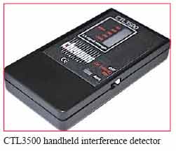
EnforcementTo progress this analysis further and to bring the OS Net reference site back to full and reliable operation clearly called for some “on the ground” investigation and mitigation. During the GAARDIAN program, strong links were forged with elements of UK law enforcement and culminated in the SENTINEL program. This activity included gaining the UK Association of Chief Police Officers ITS Working Group (ACPO ITS) as a full partner. Discussions with ACPO ITS and other law enforcement agencies (LEAs) allowed the GAARDIAN team to compile a confidential report on the events described here, which led to the deployment of LEA assets to the vicinity of the site in question. Small, handheld detection devices were used to aid in localizing any interference source, as GAARDIAN itself cannot provide a location or bearing of the interference source. (This latter capability is part of the SENTINEL program.) This article cannot provide specific details of the LEA operation nor describe how the GAARDIAN team further contributed, for reasons of operational security and possible legal proceedings. We can say, however, that the LEA ground operation did identify a source of the interference, which was identified as one of the vehicle based GPS jamming devices seen frequently on the Internet and as described in the Royal Academy of Engineering report on GNSS vulnerabilities. As a result of this event analysis, therefore, the initial assessment that the problem was manmade was proven correct. Any further action by the appropriate UK authorities is to be determined by the UK LEAs, and the GAARDIAN team will not be involved. ConclusionThis overview and case study has shown that the GAARDIAN system, although an experimental network, is fully capable of detecting deliberate and accidental GPS interference & jamming. And, as the case described here demonstrates, it is capable of being the primary detection sensor used in an operational law enforcement environment. Detection of interference events lasting just a few seconds has shown to be possible. We should also note that occasional variants of the DSS profile described in the article exhibited a “tail,” i.e., a shallow recovery back to a normal signal/noise state. This was subsequently identified as a waiting period by the vehicle emitting the jamming signal at nearby traffic lights. ManufacturersThe handheld interference detector used in the GAARDIAN program was the CTL3500 interference monitor from Chronos Technology Ltd., Lydbrook, Gloucestershire, United Kingdom. The GPS receiver system used within the GAARDIAN probe is a CTL430 also from Chronos Technology Ltd, and the eLoran receiver used in both the GAARDIAN and SENTINEL projects is a UN-150 eLoran Timing Receiver from URSANAV Inc.
|




 (3 votes, average: 1.67 out of 5)


Leave your response!