| GIS - New | |
Digital blockchain for land pooling in Delhi
The land pooling process involves certain radical changes in land administration, which should be digital, blockchain based land administration domain model |
 |
|
Abstract
The Master Plan of Delhi-2021 (MPD- 2021) has envisaged a paradigm shift in land assembly, and stipulates optimum use of land and land pooling policy for the new sub-cities. It involves the preparation of land pooling and land use plans, physical and social infrastructure and transport network plans along with equitable access to land resource, housing, services, jobs, etc. Land management involves several stakeholders, public and private institutions which require horizontal and vertical coordination by a combination of land pooling, regularisation, Transferable Development Rights, Accommodation Reservation and Transit Oriented Development. This needs radical changes in land administration, which are digital and blockchain, whereby land titling ensures social equity, jobs and land sharing.
Introduction
Land is the basis of human development, shelter and infrastructure services. Traditional planning in India entailed large scale appropriation of rural lands for urban housing, commercial centres, industries, roads and highways, airports, recreational, educational and health facilities, etc. The agitations and various court cases, e.g. at Rewari ( proposed development hub under DMIC project), Bhatta Parsaul and Jewar Airport, Greater NOIDA and Singur SEZ (WB), etc. highlight the widespread discontentment against coercive land acquisition.
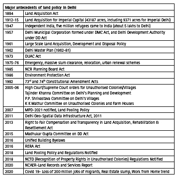
The Government in 2013 replaced the Land Acquisition Act, 1894 by Right to Fair Compensation and Transparency in Land Acquisition, Rehabilitation and Resettlement Act. As a result, the practice of compulsory land acquisition is being replaced by the concept of land sharing. Private Sector Participation (PSP) and Public-Private Partnership (PPP) in land assembly and development are being increasingly adopted in view of a) difficulty in land acquisition, b) to generate private sector resources by a market led approach, and c) land monetization so as to improve the finances for land and infrastructure development for the growing demands of urbanization.
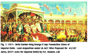
Five million refugees came to India after partition in 1947, for which the Ministry of Refugees (later Ministry of Rehabilitation) took up the housing schemes (36 rehabilitation colonies), markets and industrial areas. Licensing system was a unique feature which made these accessible to the poor refugees with low/no investment. The Delhi Development Authority was established in 1957 as planning and development agency. It adopted the system of leasehold tenure, licensing and renting of subsidized and low cost shops, sites and services.
Master Plan for Delhi -1962: To accommodate the increase of population from 2.3 m in 1961 to 5.7 million in 1981, the urban area was projected to increase from 20,000 Ha to 44,000 Ha. As such, the policy of large-scale land acquisition, development and disposal was framed, under which 90,111 acres of land was acquired.
Issues in compulsory land acquisition
The compulsory acquisition of land has raised various issues:
• Poor, Obsolete Land records
• Dissatisfaction of the landowners regarding compensation
• Delays in land acquisition
• Litigation with respect to acquisition, encroachments and compensation
• Huge public investments for land acquisition and development
• Encroachments on acquired public lands
• Lack of adequate land for social housing, infrastructure services, work centres, publicsemi- public facilities, etc.
• Poor not having access and right to the city
• Huge administrative work
• Problems of equity, transparency
• Political – bureaucratic tussles
• Lack of digitized property transactions
• Lack of enforcement against unauthorized, colonization, construction, squatting, encroachments
• Tenure and legal issues
The liberalization of the Indian economy (1992) gave a thrust to urban development and the private sector entered in a big way in real estate, housing and infrastructure projects, including ports and airports, rail freight corridors and Special Economic Zones (SEZs). The emergence of transport corridors with a substantial increase in industrial investment, services, flow of goods and people along them has been a significant feature of spatial change in recent years. The “Golden Quadrilateral” network of National Highways linking Delhi, Mumbai, Chennai and Kolkata as well as North- South and East-West Corridors, promote this type of growth. One of the recent initiatives is 1,483 kilometre long, Delhi- Mumbai (Western) Industrial Corridor (DMIC) and 1,279 kilometer long Delhi-Kolkata (Eastern) Rail Freight Corridor. To mobilise private sector and institutional resources and get multiplier effect from budgetary allocations, a facilitating approach is being adopted by the government.
Land is a State subject and various State Governments in India have adopted their own land policies. Realising the potential of urban sector in economic development, the privatisation of urban development is being increasingly adopted by the state governments, which aims at the following:
• Land value, capture by conversion of agricultural land for urban uses, Transportation Reinvestment Zones (TRZ), etc.
• Obtaining the gains of private sector efficiency
• Introducing competition in the supply of housing and other developments;
• Opening up new areas of business and creating jobs.
• Better use of lands in improving the overall economy.
DDA partnership models
The DDA and Delhi Government have adopted the model of in-situ development for resettlement of slum dwellers. The DDA’s main contribution is the land, whereas private developers bear expenses for construction and site development. For financial viability, the Master Plan for Delhi 2021 (MPD-2021) for slum development allows a density of 600 to 900 dwelling units per hectare and an FAR of 400, with 10% of floor area for commercial use. The market sale housing shall not exceed 40% of the total FAR. The Kathputli Resettlement Scheme at Shadipur (near East Patel Nagar) is a prime example of such scheme.
The DDA in 2006 adopted a PPP model for the Commonwealth Games Village, covering 11 Ha, adjacent to Akshardham Temple. Construction of 1168 flats was offered by the DDA to the bidder against upfront payment and constructing the Commonwealth Games Village flats together with site development, parking and services. The DDA and developer share ratio was 2: 3 flats. Several other PPP schemes are being taken up by the CPWD and L&DO, such as redevelopment of Kidwai Nagar, Sarojni Nagar, R.K. Puram, Nauroji Nagar, etc.
Property titles and tenure rights
As a result of centuries of land administration, Delhi witnesses various forms of land rights-both formal (deed, title, license, etc.) and informal (street vendors, slums, squatters, tehbazari, etc.). Benami, pagdi and power of attorney are quite common that are something between formal and informal tenures. Chulah tax was imposed by the British rulers in certain villages in Delhi mainly to exert political pressures on the locals. Overall, the system of land tenure/rights is quite complex and vulnerable to fraud. The most vulnerable are the properties in 2000 odd unauthorised colonies, where the land largely belongs to the government, is disputed or under acquisition. The Government in 2019 issued NCTD (Regularisation of Property Rights in Unauthorised Colonies) Regulations. According to the NCAER (2020), the status of land records and services in Delhi is as given below:
Gaps in Land records and services
• Records of Rights ———— Poor, Obsolete
• Spatial Records ————– Very Poor, Manual
• Digitised Cadastral Maps —– 53% of Villages
• Digital Registration Process —-Very Poor
• Quality of Land Records, Updation and Land Use —-Very Poor
Lack of digital Land Information System and practice of power of attorney are the major hurdles in implementation of the Land Pooling Model. This needs the adoption of information communication technologies (ICT) based digital ledgers for data management, Land Admin Domain Model (LADM), geographic information system (GIS), electronic data capture, web-based applications, satellite/Total Station/Drone surveys, national spatial data infrastructure (NSDI) and e-governance.
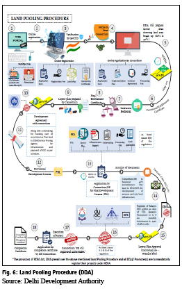
Land Pooling Model of Delhi Development Authority
Land pooling model envisages that an equal portion of land is deducted from every agricultural plot as contribution of land for physical and social infrastructure. This method, also known as a Town Planning Scheme, had its roots in “land pooling” in Germany and is being followed in Australia, Japan, Thailand, Taiwan and South Korea. This involves:
i. Land Pooling and Return without payment of compensation for land retrieved for common infrastructure,
ii. Relaying of pooled land,
iii. Carrying out infrastructure work and subdivision of land,
iv. Re-allotted part of developed land back to the owners, and
v. Selling part of developed land to meet the cost of development.
The method minimises public expenditure in the development of raw land and ensures sharing of value addition of land with the original owners. The process brings public and private investments in infrastructure development and obviates financial transactions which are typically difficult.
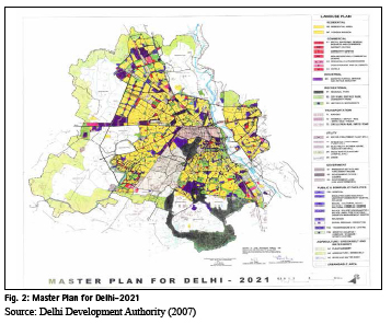
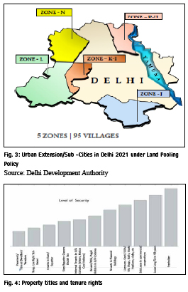
The Master Plan of Delhi-2021 (MPD- 2021) has envisaged a paradigm shift in land assembly, which stipulates optimum use of brownfield land and land pooling policy for the proposed five new sub-cities. These sub-cities would accommodate a total population of 95 lakhs, which includes about 33 lakh existing population. The total area under five sub-cities is 66,657 ha, which includes regional park/ forests/ water bodies, mandatory agricultural green belt (54 border villages measuring about 11,000 ha), existing built-up areas/ villages/ unauthorised colonies, etc. (about 7681 ha) and land reservations for power plants, services, utilities, solid waste, sewerage, etc. Out of total urbanisable area of 42,334 ha, an area of about 27,628 ha is estimated to be available for new developments. Of this about 50 per cent would be available for residential development, 15-20 per cent for greens, 10-12 per cent for transportation and 7 to 9 per cent for commercial and industrial uses. About one-fourth of the proposed urban area comprises facility corridors, mainly having integrated transit corridors, commercial, public and semi-public facilities, government and institutional uses. The zonal plans of all five zones in urban extensions of Delhi have been notified. The Land Pooling Model is based on the following guiding principles:
1. Basis of Pooling: Pooling of land will be done on the basis of sectors as delineated in the Zonal Development Plan
2. Minimum Area Requirement: Minimum 70% contiguous land of the developable area within the sector, free of encroachment, is required to be pooled to make the sector eligible for development
3. Land Holding Break-up: Of the pooled land, land owner/consortium will retain 60% and hold remaining 40% to be surrendered as and when required to the DDA/service agencies
4. Development by Consortium: 60% land to be utilized by consortium/ land owners for development of residential, commercial, public and semi-public facilities as per the policy
5. Implementation Plan: Consortium will mutually decide a formula among land owners for redistribution of developed land/build space as part of implementation plan and convey the same to the DDA
6. External Development Charges: External Development Charges (EDC) shall be applicable on entire area of pooled land to cover the actual cost of providing city-level infrastructure
7. Separate Developer Entity: Landowners/group of landowners with minimum 2 hectare of pooled land can choose to work as separate Developer Entities (DEs).
8. FAR for Group Housing and City Level Commercial and PSP shall be as per as MPD 2021 norms. 15% of FAR for EWS housing shall be given over and above the permissible FAR.
The Land Pooling Policy of the DDA was notified by the MOHUA in Gazette of India dated 11th October 2018 under section 11A of the DD Act and the Regulations were notified on 24th October 2018 by the DDA under section 57 of the DD Act. It is to be examined that the land pooling Policy is consistent with the Delhi Development Act, LARR and other legislations.
It is necessary to ensure availability of transport corridors and basic services, without causing displacement. As far as possible, land pooling and return transactions should be digital and on the spot. This will save the land-owners and developers from anxiety and will reduce administrative work, court cases, land transfer hassles, land security and vigilance. It will be necessary to create zonal land banks for return of land to poolers and also to develop Master Plan Roads (30 m and above), trunk services and facility corridors. This would enable the service agencies to plan essential public, infrastructure services, such as roads, utilities, power, ESS, water works, main sewers and drains, which are developed by different agencies/ departments. Without these services, land pooling would not work.
Redevelopment potentials
The variety of urban developments, such as existing settlements, unauthorised colonies, and slums, need a hybrid land policy with focus on optimum use of land with better services.
In Delhi, following is the rough estimate of the extent of built-up residential areas:
▪ 36000 acres –planned residential area
▪ 12000 acres –unauthorized / regularized colonies
▪ 1000 acres – government land available for social housing
▪ 2390 acres –slums & JJ clusters
▪ 6000 acres –resettlement colonies
These offer scope for densification of built-up areas and amalgamation of small plots for Group Housing (minimum 1670 sm) with common greens and parking and enhanced FAR (400 or 1.5 times the plotted development). This involves upgradation of infrastructure services, facilities and open spaces.
The redevelopment strategy cannot work without simplifying approval process. Mixed land use, incentives of higher density, extra FAR and Transferable Development Rights are necessary in these tasks. Digital property titles and transactions would greatly facilitate the process since many properties do not bear clear titles.
For sustainable and successful land pooling, the following initiatives are essential:
Digital ledgers and blockchain: A digital ledger is a geographically distributed database that is shared and synchronized across a network of the participants. It has a blockchain structure where the data is stored in blocks, linked and secured by cryptography for handling identities, contracts and assets. The blockchain is an electronic transactions system. It is based on a hash algorithm that converts data into a block.
There are three types of blockchain: public, consortium and private blockchain. A public blockchain allows anyone in a network to be involved in the process of adding blocks. A consortium blockchain requires participants to be from an organization. A private blockchain is operated by a particular organization. Every user receives a unique public key and a unique private key. These two keys can be used for privacy and authentication. Thus, a blockchain is a chain of digital signatures that are joined together in clusters with a specific block.
Broadly land registration is title based and deed-based systems. In the deed-based system of registration, a deed or a transaction of land is registered. This deed is proof of a land transaction but not the legal right. As such a transferee must trace the ownership of the land back to its root and establish if the transferor is a rightful claimant. The title-based system is the legal land right the rightful claimant for the spatial extent of the property right are registered. Deed and titlebased systems of land registration are the result of centuries of optimising land administration systems. The deed-based system is vulnerable to fraud where the chain of transactions is broken. The title-based system aims to curb such frauds.
Digital Blockchain system for land registration is indispensable for land pooling schemes in order to curb the frauds and power of attorney transactions, which are very common in urban extensions.
LADM framework
The Land Administration Domain Model (LADM) is an International Standard (IS) of the International Organisation for Standardization, as ISO 19152. It covers basic information related to components of land administration and includes agreements on administrative and spatial data, land rights and source documents (e.g. deeds or survey plans), and forms of tenurescustomary tenure, government land, and privately held land.
As such, LADM is capable of depicting the Land Administration System and different forms of land grabbing. The LADM defines the Spatial Units and different forms of property (commonly held, public or private). The differentiation is valid for converting private lands for public use (roads, infra services, facilities, parks, etc.) by taking over contiguous parcels of lands and readjustment of ownerships of remaining private lands (say 60% of original extent). The LADM, as such, assigns the class. It contains the Rights, Restrictions and Responsibilities. (Annex F of ISO 2012), which can be the basis of land adjustment and registration. For land pooling two specialised classes, one for public based regulation (AL_ Infrastructure Reserve), and the other for Land Registration, where the ownership rights and the publicly imposed restrictions are registered for each case.
Integrated and inclusive development should address the issues of environmental sustainability, city expansion, restructuring, development controls and land use. The poor and informal sectors have a claim on equitable access to resource- land housing, services, jobs, etc. Redevelopment of old, unplanned areas, unauthorized colonies and slum rehabilitation can be ensured by incentivized development rights. and infrastructure services, such as water, power and drainage, transportation. These involve several stakeholders, public and private institutions which require horizontal and vertical coordination. This can be achieved by digital platform, i.e. blockchain. In the context of heterogeneous urban character, it is necessary to adopt a hybrid approach for a land pooling, composite redevelopment and densification. The strategy of sustainable development focuses upon public greens, social facilities and utilities with minimum consumption of land.
The concept of excess condemnation can be employed to serve the twin objectives of providing a public road, highway or such facility and generate revenue by the acquisition of additional lands which are directly affected by such provision. The adjacent area is developed by the local body, the land value of which increases as a result of facility/road, and it accrues to the local body, rather than to individuals. The concept of property development along major public transport corridors/MRTS has been adopted in Delhi with grant of 50% additional FAR. This helps building up of a land bank of the local body.
The concept of white zoning: Planning norms, density, FAR and flexible land use zoning can open up new avenues for using the land as a resource for urban turnaround. It is essential to optimise utilization of urban land visa- vis Floor Area Ratio and residential density along with mixed land use and flexible zoning known as white zoning in Singapore. It allows flexibility in land use. Depending upon the feasibility of land use and floor area permissibility, the developer pays the land use and FAR charges. This strengthens the financial base of urban local body to provide services and amenities. The Old City, unplanned areas and major corridors can be taken up for white zoning. This way the old, dilapidated areas are renewed and upgraded with a wider participation of the owners and without need for acquisition of virgin, unserviced lands.
Transit oriented development: Relatively low and uniform Floor Area Ratios (FAR) have distorted urban land market by promoting sprawl, increasing transportation and infrastructure overheads. It is necessary that the FARs are rationalised to permit higher density development in the areas with adequate infrastructure and public transportation capacities, both existing and future. Gains in property values can be recouped for infrastructure development. Land Value Capture and Land Based Transportation by Transit Oriented Development are the new frontiers of infrastructure financing.
The tools of Land Pooling and Readjustment, Excess Condemnation, Accommodation Reservation, Transferable Development Rights, etc. can be effectively used for infrastructure development, while promoting private sector participation. In the built up areas, in-situ redevelopment can be promoted by grant of development rights, including incentive FAR.
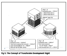
Transferable development right: Transferable Development Right enables the land acquisition for public purpose without monetary compensation, but by way of grant of additional FAR /FSI. This helps in obtaining lands for road widening, new roads, development of parks, playgrounds, civic amenities, etc.
Accommodation reservation: The Accommodation Reservation is a form of in-situ TDR which allows the land owners to develop the sites reserved for road widening or an amenity in the development plan using full permissible FSI/FAR on the plot. This way the reservations for social housing, parks, utilities, retail markets, dispensaries, etc. are implemented on private lands without the need to acquire the land by payment of compensation.
Spatial, Financial and Infrastructure Integration: Land management involves coordination among the local, state and central governments with horizontal and vertical linkages among planning, engineering, finance, legal, housing and management departments. Coordinated spatial, financial and infrastructure planning can be achieved by Capital Investment Folio (CIF), similar to what was developed for the Metro Manila Commission. This helps in coordinating the spatial plans with infrastructure investment strategies and allocating responsibilities. This also considers sustainability factors, e.g. form of urban expansion, which minimizes energy use, minimize development on high value agricultural land, avoid vulnerable groundwater resources and optimize use of land (e.g. mixed use areas, redevelopment and redensification, multiple use of buildings, etc.).
Infrastructure bundling: Urban projects, such as slum redevelopment, roads, and airports are being increasingly financed through award of land for market to partly compensate the cost of development. Slum Rehabilitation at Kathputli colony, Delhi, IGI Airport, New Delhi, Redevelopment of the New Delhi Railway Station, Sports City/F-1 Racing Track, Yamuna Expressway (UP) and Ganga Expressway in Uttar Pradesh are some of the examples of such projects where the cost of infrastructure development is part-funded by the award of land rights.
Betterment levy and land value capture: For the sake of equity and fair distribution of public resources, the concept of betterment levy obliges the land owners to return a part of land value addition or profit that results from public investments. Betterment levies help to finance urban development and public services by the ULB and service agencies.
The infrastructure development can be financed through the recovery of EDC, conversion charges, FAR charges, Betterment levy, etc. However, to ensure the availability of infrastructure and corridors prior to real estate development, it is necessary to separate the surrender/ return of land and payment of EDC, Betterment levy, Conversion Charges, FAR Charges, etc. vis-àvis grant of development right and change of land use. The land owners can be given a choice or a combination of cash and development right.
Implementation and regulatory process
The private sector participation in land pooling and its development involves various regulatory functions, such as given below:
• Working out the rules, regulations, procedures and guidelines, grant of licenses, for private sector participation in real estate, land assembly, planning, infrastructure development, redevelopment, housing, etc.
• Spatial Data Infrastructure (SDI) /computerization of land records, online, one window approval of plans.
• Compulsory acquisition of land which effect the composite land pooling, and infrastructure development
• Procedures for grant/revoke of licenses, approvals and planning permissions.
• Model agreement and MOU with land owners for land pooling, preparation and approval of the plans of land pooling/assembly and land return.
• Issue of Transfer of Development Right and Accommodation Reservation Certificates.
• Enforcement and monitoring of regulation for private /PPP developer, housing and service agencies, etc. including progress of work and financial transactions.
• Regulations/procedures to oversee the compliance of the legal, administrative and financial commitments.
• Financing and accounting procedures.
• Procedures to deal with appeals, grievances and complaints.
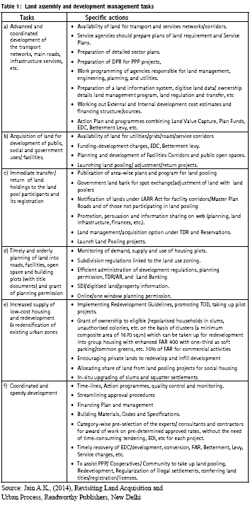
The land policy needs simultaneous process reforms for better control over time, bridging the gap between demand and supply, overcoming delays and cost overruns, time-bound planning and effective monitoring. Technological interface vis-a-vis energy, water and environment with reference to standards and specifications, infrastructure, construction, maintenance is a major consideration. There is a need to adopt new contracting procedures for efficiency, quality of service, delivery and transparency. Table 1 gives a list of the actionable tasks.
The partnership strategy may not succeed without complimentary organisational innovation and reforms, which have to ensure sustainable and inclusive urban development. This needs a hybrid regulatory framework that integrates the physical, economic, and social development. There is a need to revisit the existing procedures, development control norms and space standards keeping in view the growing economy, land crunch, and changing needs of the people. This may need the setting up of a Land Pooling Regulatory Authority to regulate the process of land assembly/pooling and development, redevelopment, housing, etc. and to oversee the compliance of the legal, administrative and financial commitments.
Conclusions
The land pooling process involves certain radical changes in land administration, which should be digital, blockchain based land administration domain model. The purpose of new model is to make the land titles as a tool of right to the city, social equity, jobs and transparency. The focus has to be on sustainable development and inclusion for which it is necessary to revive the property licensing for small shelter, shops, kiosks, clubs, facilities, etc. This means a review the auction policy, rationalization of the reserve pricing and conversion charges. For optimum use of the land, it is necessary to take up the redevelopment and land recycling. The system of land use zoning should be flexible. To ensure a composite, compact and dense urban pattern with safe building, parking, common space and access of emergency vehicles, the reservations of public greens, transport, physical and social infrastructure are crucial. This needs a closer spatial-institutional-financial integration. For a sound legal backup, the land pooling policy should be consistent with the Delhi Development Act 1957, LARR Act 2013, Transfer of Property Act 1882, Revenue Act 1963 and Registration Act 1908.
References
1. AMDA (2009) Land Policy for NCTD-2021, New Delhi: Association of Municipal and Development Authorities
2. Archer, R W. (1993) Urban redevelopment with landowner participation using the land pooling/ readjustment technique. Bangkok: Asian Institute of Technology,.
3. Baker, Lee and David Sims (1991) India Public/ Private Partnerships in Land Development
4. Bansal, A. and A.K. Jain (1986) “Acquisition, Development and Colonisation of Land in Gurgaon: The Impact of Strategies and Programmes.” Research Study for Indian Human Settlement Program, New Delhi,
5. Banshree, Mitra (1989) Lands Supply for Low Income Housing in Delhi. from the New Suburbs. Edited by Paul Baross. New Delhi.
6. Bell, Keith Cliford, World Bank, Land Governance, in Coordinates, December 2011, pp. 18- 20
7. Billand, Charles J. (1990) Delhi Case Study: Formal Serviced Land Delivery. Washington D.C. Prepared for USAD, PA.
8. Courtney, J. (1978) Urban Land- Uses Regulation”, in Urban Land Policy: Issues and Opportunities, edited by H. Dunkerly and C.M Whitehead, World Bank Publiction.
9. Delhi Development Authority (DDA) Guidelines on Land Management. New Delhi: Unpublished reports, 1992 and 2014.
10. DDA (2007) Master Plan for Delhi : 2021, New Delhi: Delhi Development Authority.
11. DDA (1981) Disposal and Development of Nazul Land Rules.
12. Hispanha JP, Tarun Bhawana, Christian Lemmen & Jaap Zevenbergen (2014) Can LADM contribute to a More Fair Largescale Land Acquisition, Coordinates , January , New Delhi
13. Kalantri Mohsen, XuclingChen, Zhouyang Wang, Luan Nguyen (2018) From Oral Agreement to Distributed Agreement: Digital Ledgers in Land Registration, Coordinates, December, New Delhi
14. Jain A.K. (2017) Urban Transformation, Discovery Publishing House, New Delhi
15. Jain A.K. (2018) City Planning for a Changing India, Bookwell Publishers, New Delhi
16. Jain, A.K. (2015) Smart Cities: Vision and Action. Discovery Publishing House, New Delhi,
17. Jain A.K. (2016) Building 20 Million Homes, Discovery Publishing House, New Delhi.
18. Jain, A K. (2015) Revisting Land Acquisition and Urban Process, New Delhi, Readworthy Pub.
19. Jain A. K. (2015) Colonial Delhi, Kaveri Books, New Delhi
20. Jain A. K. (2009) Urban Land Policy and PPP for Real Estate Projects, Readworthy.
21. Live Mint, (2015) The Evolution of Land Acquisition Act, New Delhi, May 22.
22. McKinsey Global Institute (2010) India’s Urban Awakening, Mumbai
23. Mishra, B. (1990), A Comparative Study of Urban Land Management (ULM) in Selected Developing Asian Countries and Japan in Economic Region Planning Research, No. 93. Economic Research Center, Nagoya University, Nagoya, Japan.
24. MOHUA (2015) URDPFI Guidelines, New Delhi
25. Nandal, Vikas, (2014) Land Acquisition Law in India: A Historical Perspective, International Journal of Innovative Research and Studies
26. NCAER (2013) Evaluation and Review of Land Pooling and Development Models of Delhi, unpublished report, New Delhi.
27. NCAER (2020) Land Records and Services Index (N-LRSI-2020) NCAER, New Delhi
28. Ribeiro, E.F.N. (2018) Emerging Spatial for Socio-Economic Development in India, in Bhide, The Land Question in Urban Development, NCAER/Academic Foundation, New Delhi
29. Preeti (2013) Limits to Absolute Power: Eminent Domain and the Right to Land in India, EP Weekly, May 11, pp. 40-52.
30. Saxena, K. B. (2011) Rehabilitation and resettlement of displaced persons. Chapter three in Development-Induced Displacement, Rehabilitation and Resettlement in India. Routledge Contemporary South Asia.
31. Shiva, Vandana. S. Javi, S.M. Fontana (2011) The Great Indian Land Grab, Navdanya, New Delhi,.
32. Sorensen, Andre (2000) Conflict, Consensus or Consent: Implications of Japanese Land Readjustment Practice for Developing Countries, Habitat International Vol. 24 pp. 51-73,.
33. TCPO (2011) Status of Town and Country Planning Departments and Acts in different States and UTs in India. Spatio-Economic Development Record, Vol 18, No. 5, New Delhi,
34. UN Habitat (2013) Planning and Design for Sustainable Urban Mobility, Nairobi.
35. USAID (1991) Constraints Affecting the Efficiency of Urban Land Markets in India, Washington DC.
36. Wallace, J. and I.P Williamsons (2006) Building Land Market, Journal of Land Use Policy, Vol. 23/2 pp. 123-135.
37. World Bank (2009) Reshaping Economic Geography: The World Development Report, Washington DC.


 (30 votes, average: 1.00 out of 5)


Leave your response!