| Applications | |
Development of fit-for-purpose land administration country strategy
The paper discusses the specific strategies to implement the proposed land policy in Nepal |
 |
|
 |
|
 |
|
 |
|
 |
|
 |
|
Existing Nepalese Land Administration System (LAS) only deals with the formal or statutory land tenure system. Out of total arable land, approximately 75% is formally registered in the national cadaster. Remaining 25% with estimated 10 million physical parcels, mostly owned by socially and economically deprived (SED) classes are outside the formal cadaster and under constant fear of eviction. Further, unrecognized land tenure restricts the settlers for getting any compensation and government grants. Nepal Government is working on an integrated and consolidated land policy to address this shortcoming. The policy is aimed to recognize and respect all land tenure types. Therefore, the Nepalese LAS requires a new and innovative solution to be able to deliver security of tenure for all which is affordable, flexible and can be implemented to deliver results in a relatively short period. The Fit-for-Purpose (FFP) approach to land administration has emerged to meet these requirements. In this context, Nepal Government decided to develop land administration strategy for implementing progressive provisions outlined in the new Nepalese Constitution, existing and proposed land policies in compliance with international instruments such as the Voluntary Guidelines on the Responsible Governance of Tenure (VGGT), the New Urban Agenda, Sustainable Development Goals (SDGs) and human rights frameworks. This paper outlines the process in developing such a strategy in Nepal based on FFP approach. Further, the paper summaries the results of the FFP country level strategy for Nepal with reference to the guiding principles and key provisions for providing universal security of tenure across the entire country. The study finds that the FFP strategy is feasible and can be applied in developing countries as a quick and low-cost solution with reasonable accuracy to support good land governance to support continuum of land rights.
Indroduction
Existing Nepalese land administration system (LAS) only deals with the formal or statutory land tenure system. This includes only land that has been registered in the national cadastre. Almost 28% of the total area in the country is arable, around 75% of which is formally registered in the cadastre whose tenure is secured. The LAS does not deal with non-statutory or informal land tenure which is estimated to be approximately 25% of the total arable land and settlements and are outside the formal cadaster. In the lack of any firm records, this is grossly estimated to be around 10 million physical parcels on the ground. This means that a significant amount of the Nepalese population is living in informality without any spatial recognition and without security of tenure.
Mainly three types of non-statutory land tenure in the Nepalese society exist (Joshi, Chhatkuli, Panday, & Dev, 2017) as mentioned below:
i. The land on which rights of the settlers are recognized but not formally registered and categorized as Non-formal. The right is socially unchallenged and established. Such land can be registered under the existing legal framework though it has not been materialized due to technical and logistical reasons
ii. The land on which rights of the settlers are neither legally recognized nor registered in the official cadastre is termed as In-formal. The settlers have been occupying the land for quite a long time. Their possessions are normally accepted and not challenged by the society. However, the land cannot be registered under the existing legal framework
iii. Illegal holding of settlers over private or public land is termed as illegal possession or encroachment. The land originally belongs to some other private or legal person, institution, Government or public/community which is being captured and settled by the other group of people and in general such tenure is neither socially nor legally recognized
Given the numerous ways of land use and their possession, their identification needs a simple, basic and understandable system. The challenges set by the overall global sustainable development agenda requires good land governance which will only be achieved when effective land administration systems are fully operational. Therefore, novel solutions are required that can deliver security of tenure for all, are affordable and can be quickly developed and incrementally improved over time. The FFP approach to land administration has emerged to meet these challenging requirements. The study aims at implementing progressive provisions on land tenure and management as outlined in the new Constitution, and in compliance with international concepts and (best) practices as outlined in the Sustainable Development Goals (SDGs), Global Land Tool Network (GLTN) tools and Voluntary Guidelines on the Responsible Governance of Tenure (VGGT) components.
The FFP approach to land administration offers a viable, flexible and practical solution to provide security of tenure for all, quickly and affordably, and to enable control of the use of all land. It provides a new, innovative and pragmatic solution to land administration where current land administration solutions are not delivering. The solution is directly aligned with a country specific needs, is flexible to accommodate several types of land tenure, and can be upgraded when economic opportunities or social requirements arise. It is highly participatory, can be implemented quickly and will provide security of tenure for all. Most importantly, the FFP approach can start quickly using a low-risk entry point that requires minimal preparatory work. It can be applied to all traditions in land tenure across the globe.
Nepal has adopted federal system wherein state power including executive, legislative and judicial authorities are distributed within Federal, Provincial and Local Level Government bodies. Implementation of land administration falls mainly under the jurisdiction of local level government. Therefore, local level governments will now have to provide land administration services with limited technical human resources as well as infrastructure.
In this context, Nepalese land administration (LA) must undergo a thorough transformation to meet quick and affordable solutions necessitated for allocation of land and recognition of tenure after the Gorkha-earthquake and the state restructuring into a federal system.
Problems and challenges of unsecured tenure of land in Nepal
Five representative examples are presented here to highlight the challenges of unsecured tenure of land in Nepal:
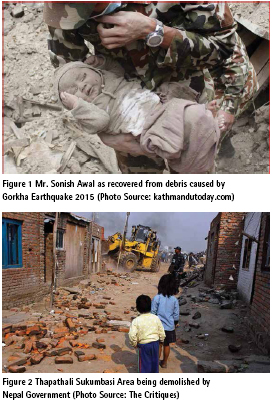
i. Figure 1 became viral in the world media during 2015 Gorkha earthquake. The baby seen in the picture below is Mr. Sonish Awal, son of Mr. Shyam Awal who has been living in Sanothimi area of Bhaktapur District for more than two decades. Their house was destructed by the earthquake and the baby was buried under the collapsed house who was successfully rescued after 22 hours. Nepal Government decided to provide compensation to the earthquake victims who lost their houses. When Mr. Awal claimed for the compensation, the government asked him to produce the land ownership certificate of his land/destroyed house. Unfortunately, Mr. Awal didn’t have one as the land was not registered in the Official Cadastre. As Mr. Awal was a genuine earthquake victim who lost his home and the whole world knew about his story, the government later changed the policy and he could get compensation later. Because of the informality, he was previously denied the government’s grant for rebuilding his house.
ii. Nepal is to develop a fast track highway joining Kathmandu to the Terai area of Nepal. The alignment has been fixed. However, when the project started, there were several households already settled and cultivating the land along the proposed alignment. The government decided to compensate the landowners who would lose their lands and/or houses because of the proposed highway. Unfortunately, many of the settlers/land holders did not have the land registered in their name as the land belongs to the government (Eilani land). The lands, according to the record, already belong to the government so they cannot be compensated to the people for the same. On the other hand, the people have been occupying and using the lands for decades. After Nepal Government formed a highlevel taskforce by cabinet decision (Republica, 2011), compensation was paid to the owners of unregistered land too. There are several such cases of informality which have been creating severe disturbances on the pace of development and construction of large infrastructures in the country.
iii. Informal settlement of Thapathali, on the bank of Bagmati River is well known area in Kathmandu, the Federal Capital City. More than five hundred families have been living there for decades. Some of them have developed their colony with permanent houses where the municipality and other service providers have provided basic urban infrastructures and utility services such as roads, drinking water, electricity supply and telephone. However, the area is officially public land and the settlers have occupied it informally without having any proof of ownership. When Nepal Government decided to use the land for public infrastructure development, the settlers did not agree to leave the place claiming that they are landless, and the government should allow them to reside on the land. In 2011 AD, then Government forcefully evicted some of the settlers and destroyed the houses built on the land (Figure 2). This action of the government was very much criticized by various human right agencies and international humanitarian organizations. The government has withdrawn the decision and the problem still exists. The government doesn’t have any records on who are living there, how many of these families and for how long. This is causing further proliferation of slums, obstructing development activities and worsening the beauty of the city.
iv. Similarly, many people occupied land of some other land owners in some part of the country mainly in the western Terai during decade long Maoist conflict. The then rebel’s administration registered land transactions of sometimes the captured land or in other cases due to inaccessibility to the government land registry office. Now, after Comprehensive Peace Agreement, the legal title-holders or landlords are claiming back their land as they are the legal owners with formal titles, however, thousands of the households have already settled and claiming that they have bought it/registered from the Maoist formed local government. Nepal Government doesn’t have any proper cadastral database on how much land has been captured, where are they and how many households are living on such lands with informality. This kind of informality is disturbing social peace and harmony in the society.
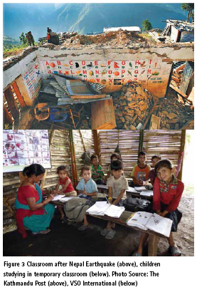
v. More than three thousand public schools’ buildings were either destroyed or partially damaged in districts affected by the 2015 Gorkha Earthquake. The schools’ activities are being conducted in temporary houses (Figure 3) in adverse environmental conditions. Though Nepal Government has allocated budget for reconstructing these schools, more than one thousand schools are unable to build the schools’ building. These schools do not have land owner certificate in the name of the school. As the schools do not have the land ownership certificate the building permit cannot be issued, and they cannot build class rooms on such land.
Going through these representative cases, it can be concluded that a Fit-For-Purpose (FFP) land administration system is required in Nepal to record the existing situation of informal land tenure quickly which is affordable and require fewer human resources and infrastructure. It further necessitates to test such tools in identification, verification and recording (IVR) of spatial and non-spatial data/ information on informal land tenure.
Motivation for preparation of FFPLA strategy for Nepal
Constitution of Nepal, Land Use Policy 2015 and Land Policy (in Cabinet of Ministers)
The Constitution of Nepal promulgated in 2015 has the following key mentions on land rights, security of tenure and land management.
▪ Every citizen shall have right to proper housing [Article 37(1)]
▪ No citizen will be evicted from or encroached on the housing, except in accordance with law [Article 37(2)]
▪ Landless Dalits (so called untouchable cast) will be given land for one time [Article 40(5)]
▪ Implementing international treaties and agreements to which Nepal is a State party [Article 51.b.(3)]
▪ Guaranteeing good governance by ensuring equal and easy access of people to services provided by the State and making public administration clean, competent, impartial, transparent, accountable and participatory [Article 51.b.(4)]
▪ Abolishing dual ownership and implementing scientific land reform [Article 51.e(1)]
▪ Discouraging absentee landownership and land consolidation for enhancing productivity [Article 51.e(2)]
Land Use Policy, 2015 and the National Land Policy (draft under discussion in cabinet) are designed to ensure how these constitutional provisions are implemented.
VGGT and other commitments in the international platform
A good land administration system should follow VGGT Guidelines, Universal Declaration of Human Rights (UDHR), International Covenant on Civil and Political Rights (ICCPR), International Covenant on Social, Economic and Cultural Rights (ICSECR) and other international treaties and covenants related to human rights and rights to the access of property and economic resources.
Emerging technology and GLTN tools
A land tool is a pragmatic way to solve problems in land administration and management. It is a means of implementing principles, policies and legislation into action. It consists of a wide range of methods: from a simple checklist for conducting a survey, a set of software and associated protocols to an extensive set of guidelines and approaches. For land tools to provide benefits to the poor, vulnerable, disadvantaged groups and women, they need to have the following features (GLTN, 2018):
▪ Affordable
▪ Equitable and gender-responsive
▪ Governance
▪ Subsidiarity
▪ Sustainable
▪ Systematic, large-scale
▪ Pro-poor
The Global Land Tool Network (GLTN) is a coalition of global, regional and national allies contributing to poverty alleviation through land reform, improved land management and security of tenure especially with the development and dissemination of propoor and gender-responsive land tools.
“Breaking the poverty cycle by contributing to poverty alleviation through land reform, improved land management and security of tenure” is the objective of GLTN. To meet its objective, GLTN has developed 2 Social Tenure Domain Model (STDM) and Gender Evaluation Criteria (GEC) which are being testing in many countries. Further, it has developed 16 more significant land tools. These tools are embedded in 5 predominant themes and to address 8 cross cutting land related issues.
Sustainable Development Goals (SDGs)
Land governance is about how effectively and efficiently policies, processes and institutions by which land, property and natural resources are managed. A comprehensive land governance necessitates a legal governing framework as well as operational processes for executing policies reliably within a country in a sustainable way. Land administration systems provide an infrastructure for implementing land policies and land management strategies in support of sustainable development. Access to resources including land and security of tenure for Ending Poverty (SDG 1.4), Zero Hunger (SDG 2.3) and Gender Equality (SDG 5a) are required in addition to Safe, Resilient and Sustainable Cities and Human Settlements (SDG 11).
The LAS should allow the implementation of land policies to fulfil political and social objectives and to achieve sustainable development goals. Good land governance should also be a means of supporting the 17 sustainable development goals (SDGs) which has 169 targets. A good land governance requires these core dimensions of the global agenda to be followed for empowering people through tenure security, food security, access to land and natural resources, and no land conflicts.
Developing strategy for implementing FFP in Nepal
The process of developing FFP strategy included extensive desk study and review of appropriate literature, interview with relevant stakeholders such as highlevel government officials, land right activists working in the area, civil society organizations, academicians and targeted people. Several workshops and seminars were organized at central and local levels and results from the recent studies on locally existing tenure typology in the country and the application of FFP approach for tenure security in post-earthquake disaster in pilot areas were also taken in consideration. The FFP strategy fully dwells with the three framework components: Spatial, Legal and Institutional (Enemark, Mclaren, & Lemmen, 2016)
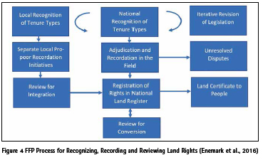
The FFPLA approach recommends that the activities of recording and registering land rights should be conducted by administrative institutions under delegated authority wherever possible. It will minimize the amount of time involved in recording and registering land rights. The FFPLA is primarily aimed at being implemented as national level programs to deliver security of tenure for all. It is a pro-poor approach that recognizes and legalizes all legitimate rights throughout the country. However, it requires political commitment up front to design and execute such national level programs within a short timeframe and at affordable costs. In cases where this political commitment is not yet in place or where there is large categorizes of ambiguous occupancy rights, the FFP approach may well be implemented incrementally through local pro-poor recordation initiatives, which starts by recognizing and recording legitimate rights as found in the local communities. These local initiatives may gain enough momentum and acknowledgement to eventually trigger wider incremental change which eventually lead to national recognition with corresponding changes to the legal and regulatory framework. The local propoor recordation initiatives can therefore work in parallel and be a supportive component of the national recordation process or act as a driver for change to help a country adopt the FFPLA approach.
As numerous types of land occupancy with ambiguous rights exist in Nepal, it may be considered that recognition and recordation of such informal lands start by local pro-poor recordation initiatives followed by national level programs (Figure 4). The national approach is shown in the center column starting by recognizing the various kind of tenure types to be enshrined in the land laws.
On this basis the mapping and recording in the field can be undertaken through a participatory approach and the result can be recorded in the land register. The local approach is shown in the left column. This approach will identify and record the actual legitimate land rights through a participatory approach. These rights can then eventually be considered and recognized at national level and entered into the land register.
The paper discusses the specific strategies to implement the proposed land policy in Nepal focusing on addressing informal/ non-statutory land tenure and its management according to the Fit-For- Purpose concept. The spatial, legal and institutional frameworks to be designed and implemented for proper management of such land tenure are briefly discussed.
Spatial framework
The spatial strategies to be adopted for administering informal land tenure are:
Mapping and recording nonstatutory/ informal land tenure
To deal with these kinds of non-statutory tenure issues, capacity of the government needs to be increased. To undertake timely, cheaply and sufficiently adequate survey for areas not yet surveyed, appropriate (Fit-For-Purpose) approaches should be applied to acquire the parcel boundary data, and, at the same time, by using a participatory approach, the various kinds of tenure held by people can be recorded.
Currently, Nepal doesn’t have database on informal/non-statutory land tenure and such settlements in official cadastre. Most of the landless people have occupied government or public land or are leaving in other legal owners’ land as tenants without secured or formal rights on it. It is very unjust that the existence of such people on such land is not even recorded in the official register.
Constitution of Nepal has ensured right to housing for every people. This situation is considered as violation of human right according to the Universal Declaration of Human Right and other conventions. Therefore, serious efforts are needed to recognize informal land tenure. To deal with the informal tenure, VGGT principles should be adopted according to which, the state should do the following (FAO, 2012):
▪ Recognize and respect all legitimate tenure rights
▪ Safeguard legitimate tenure rights
▪ Promote and facilitate enjoyment of legitimate tenure rights
▪ Provide access to justice to deal with infringements (violation) of legitimate tenure rights
▪ Prevent tenure disputes, violent conflicts and corruption
To implement these principles, mapping and recording informal land tenure is the first step. In absence of such recognition of the settlement and land tenure, many complications are seen during rehabilitation and resettlement of earthquake and flood victims. Quick and efficient mapping of such land tenure and settlements can be done by using different techniques. High resolution satellite images can be one for mapping. Participatory methods should be applied for adjudicating rights of individual/family in the plots. It can be verified by the community involvement as well. Dense settlements can also be mapped and recorded in the same way e.g. using drones. Point cadastre can also be an alternative for fast and efficient record maintenance. Opensource software can be used for keeping the data. STDM promoted by GLTN/UNHABITAT can be a solution.
Focus on security of tenure for all
The main purpose of land administration systems is to provide security of tenure for all. The other purposes include enabling access to credit and investments, facilitating valuation and taxation, planning and control of the use of land and natural resources, supporting land development, and providing land parcel and land owners information to support decision making on land policy. The systems should identify and delineate the occupancy as well as the use of the individual land parcels. It should be established according to the purpose. Security of land tenure only requires satisfactory identification of the land parcels and buildings on satellite/ aerial images or on a map. It does not need accurate boundary surveys using sophisticated equipment and highly skilled human resources with longer survey time as well as high budget requirement.
Accuracy of parcel boundaries should be seen as a relative issue and can always be upgraded over time. Accuracy requirement is obviously lower for low value lands in rural areas than in densely built up and high value urban regions, where accurate field surveys may sometimes be justified. This principle is also being practiced by Nepal Government by producing different scales of cadastral (1:500 for municipalities to 1:2500 for rural areas) and topographic maps (1:25000 and 1:50000). The registration of legal and social tenure rights requires identification of physical land parcels and objects. The identification through visible boundaries as seen in the aerial/satellite imagery will be adequate for securing and recording the connected legal and social land rights. Non-visible boundaries can be captured by supplementary measurement using handheld GPS or conventional field surveys, for example. If occupants want the exact boundary delineation for some specific purpose, it can be measured and registered at their costs.
Official inventory of state land is still not realized completely in Nepal. Therefore, mapping of government and public land and creating an inventory of such land is necessary. To deal with this, rights, restriction and responsibility (RRR) over the land and land-based resources should also be well defined. Community user groups can be created and Standard Operating Procedure (SOP) of use of such land can be developed in the leadership of local institutions. Various state of the art but cheap and efficient techniques can be used for creating such inventory. Along with high resolution satellite images, drone images and orthophoto (in case of high value land in urban areas) can also be used as per specific need and availability.
Legal framework
The existing legal framework in Nepal does not completely address several provisions made in the new constitution and as proposed in the draft for a new national land policy. Therefore, an appropriate legal framework should be designed for addressing the newly enacted constitutional provisions and the relevant policy issues at federal, provincial and local levels.
A new Land Administration and Management Act
A new unified Land Administration and Management Act (LAMA) should be drafted and enacted based on the several existing acts, to improve efficiencies, streamline overlapping provisions and address gaps.
Addressing informal tenure
New legal provisions should be made to recognize informal tenure and safeguard the rights of informally settled people. The Continuum of Tenure approach (Du Plessis, J. ; Augustinus, C. ; Barry, M. ; Lemmen, C. ; Royson, 2016) can be adopted for recognizing informal tenure rights of these people. In this approach, any types of relations of these people to land are recognized and recorded as it exists on the ground.
Using the STDM approach, Identification, Verification and Recording (IVR) of the people’s association and relation to land can be recorded.
Alternative Dispute Resolution (ADR) mechanism and Provision of land tribunal
Majority of the disputes registered in different courts are related to land. The court procedures are lengthy, time consuming and costly. Most of these disputes can be litigated with the involvement of community and/or appropriate mediation methods outside of the court, which can be cheaper, faster and even address the issue with mutual understanding and trust to end it up with a win-win situation. Therefore, the new legislation should have provisions of Alternative Dispute Resolution (ADR) mechanism such as community involvement and third-party mediation in local level. Judicial Committee under the chairmanship of Deputy Mayor/Vice Chairperson of the local government is a good move in this regard.
Land disputes have several dimensions and need specific skills, technology and human resources. Therefore, the new legislation should have provision of constituting Land Tribunals to deal with complicated land disputes, which cannot be resolved by the local efforts. This can facilitate the court process to achieve quality justice in less time and at lower cost.
Land banking
Land owners who have been involved in the profession other than agriculture can contact the bank for sale, mortgaging, leasing and financing. The small holders, landless, squatters, peasants etc. can be allocated the land stocked at the bank for their livelihood, employment, economic strengthening and entrepreneurship development.
Management of state land
Surveying, mapping, record management and security of all state land should be clearly defined in the new legal framework. Various overlapping and contradictory provisions exist in the current legal system. Various laws allocate the responsibility of state land protection and management to different institutions. It creates confusion and dispute over the jurisdiction and consequently the protection and management of state land cannot be done efficiently and effectively. Hence, a new clear and unambiguous jurisdiction should be defined, and roles and responsibilities should be allocated to appropriate institution, which can protect, use and manage all state land optimally.
Selection of appropriate technology
New legal systems should be designed in such a way that it can adopt Fit- For-Purpose approach to deliver good, cheap and fast services and ensure ‘Good-enough’ land governance.
Institutional framework
For the implementation of the provisions proposed in Land Policy, it is vital to develop and strengthen institutional framework in three levels of government. Several informal discussions have been conducted with various experts, professionals and stakeholders. The main strategies suggested for creating institutional framework for implementing FFPLA are categorized under three broad topics: Federal and provincial land authority, Local land authority; and other institutional issues.
Federal and provincial land authority
Strengthening/restructuring national land agencies such as Survey Department, Department of Land Reform and Management, etc. is needed to develop a consolidated and unified land authority at federal level.
Provincial level land agency should be established which should be responsible to deal with the state level functions as described in the constitution. This structure will be new as there are no such institutions present currently in this level.
Local Land Authority
Local level institution on land management should be established to deal with the local level functions. This structure will be new as there are no such institutions present currently in this level. However, the district level offices can be merged and restructured to some extent in order to address the local needs. The local land authority will be responsible for addressing the following land administration issues:
▪ Surveying and mapping: The local land authority may consist of a surveying and mapping unit which would be responsible for preparing and updating cadastral maps and databases
▪Land ownership management and registry: Land tenure and ownership management unit is also needed within the local land authority, which would be responsible for land ownership transfers, registration of deeds regarding land transactions, buy and sale, inheritance, land records maintenance and updating etc.
▪ Alternative dispute resolution (ADR) mechanism: Local land authority should consist of some Alternative Dispute Resolution (ADR) mechanism for land dispute resolution.
▪ Land tribunal: Land Tribunal is another institutional mechanism that can be developed for efficient and effective land dispute resolution.
▪ Community user’s groups: Best and optimum use of land and landbased resources can be ensured by involvement of community in land management process. Nepal has a very good experience of community forest management which is considered as one of the best examples in the world. Similar approach can be adopted in local land use and land management in community level. Various under-utilized and abandoned barren lands can be highly productive and income generating resources if they would be handed over to community. Therefore, community user’s groups can be formed, and certain types of land can be handed over to the group for its proper use and management.
▪ Land valuation: Land valuation unit is needed in the local government. Policy, acts, standards can be formulated in collaboration with the federal and provincial agencies and can be implemented by the provincial institutions in association with the local government.
▪ Land use planning: A specific land use planning and technically facilitating agency may also be needed at the local level. However, the policy and act formulation, decision on technical standards can be done at federal and provincial level. This unit will be responsible for formulation and implementation of local land use planning.
▪ Land banking: Land bank, land stock market in local level should be established. However, the policy, acts, standards should be formulated at the federal and provincial levels.
Other Institutional issues
On top of institutional setup at federal, provincial and local levels, the following additional set ups are recommended:
▪ Professional organizations and associations: Professional organizations and associations may play important roles for continuous professional development. Land administration and management sector in Nepal can also benefit from making appropriate institutional mechanisms to accommodate different professional organizations and collaborating with them for good reasons.
▪ Survey licensing board: Survey licensing board is needed at the federal and provincial levels to decide on the qualification and skill needed for surveyors. This board may be responsible for awarding appropriate license for private surveyors.
▪ Private surveyors: Private surveying companies/individuals can be provided license to carryout surveying and mapping functions. In the current tradition of governance, roles and duties of the government are squeezing and are limited to the regulating, coordinating and facilitating tasks.
▪ Human resources: Nepal is producing roughly 120 Geomatics Engineers/ Senior Surveyors, 150 Surveyors and 200 Assistant Surveyors annually. Some of these human resources are consumed by the private companies, some of them use to go abroad for higher study and some other in foreign employment and remaining in the government sector. Each local government unit will be looking for such human resources in near future to run their land administration functions. To fulfill this need, some short-term packages including basic surveying, measurement and mapping skills, basic GIS, GPS and image interpretation techniques and basic social and legal know-how of land administration can be developed and training courses can be conducted. These human resources, after getting appropriate license, may be involved in various surveying and mapping jobs as per requirements.
▪ Infrastructure and ICT: Physical infrastructures are necessary for sustainable capacity development. Current institutions need basic IT facilities for delivering their services effectively and efficiently. Land administration services also needs modernizing. Application of IT for transparency and winning peoples trust, appropriate infrastructures are most essential for this purpose.
▪ Tools and techniques: Appropriate institutional capacity is needed to handle the various tools and techniques of land administration and management in different levels. Appropriate institutional capacity can be required to accommodate, modify and customize the systems, making templates, developing uniform and consistent guidelines, standard operating procedures and working manual. A technical team and coordination mechanism would be very important for ensuring effective implementation and achieving consistent results throughout the local government within/among the provinces.
Conclusion
Nepalese land administration system is not yet complete and up-to-date. Official cadastre doesn’t have a coverage of the entire country. Informal land tenure is not yet recognized and recorded in the official cadastre. FFPLA approach can be a good concept to incorporate and apply in Nepal. This concept in one hand may successfully be adopted to address the current issues in informal land tenure system; on the other hand, this can be good enough, cheap and fast in comparison to the existing technology and methods of LAS. Various issues and limitations are identified to improve the spatial, legal and institutional aspects of LAS. Nepal has recently enacted the new constitution. It has made many remarkable and progressive provisions to make land administration system more equitable, inclusive, pro-poor and gender responsive. Various other provisions such as local governance act, National land use policy etc. have been made to achieve good land governance. New land policy is under discussion and expected to be endorsed by the government soon. These documents have made several new provisions which may not be easily implemented with the existing and traditional Standard Operating Procedure (SOP) adopted by the government. Hence, new Fit-For-Purpose approach should be suitable for implementing these provisions.
Recommendations
The following are the recommendations:
▪ Fresh field work and study should be conducted at some locations (at least two: one in rural and another in peri-urban area) regarding the appropriateness of data acquisition and processing using Fit-For-Purpose approach
▪ Standard Operating Procedure (SOP) and Working Manual should be developed before implementation
▪ Standard Template for uniform use of tool should be developed. Also, appropriate tool should be customized to fit Nepalese context
▪ Short-courses focusing application of FFPLA should be launched
▪ Capacity of local governments should be developed regarding application of FFPLA
References
Du Plessis, J. ; Augustinus, C. ; Barry, M. ; Lemmen, C. ; Royson, L. (2016). The continuum of land rights approach to tenure security : consolidating advances in theory and practice. In Scaling up responsible land governance, proceedings of the annual World Bank conference on land and poverty, 14-18 March 2016, Washington DC, United States. Washington, D.C., 2016 (p. 48).
Enemark, S., Mclaren, R., & Lemmen, C. (2016). Fit-for-Purpose Land Administration: Guiding Principles for Country Implementation. Retrieved from http://www.gltn.net/index.php/ publications/publications/download/2- gltn-documents/2332-fit-for-purposeland- administration-guiding-principlesfor- country-implementation.
FAO. (2012). Voluntary guidelines on the responsible governance of tenure of land fisheries and forests in the context of national food security. FAO. Rome. Retrieved from http://www.fao. org/docrep/016/i2801e/i2801e.pdf
GLTN. (2018). What are the features of pro-poor gender responsive land tools? Retrieved February 1, 2019, from https://gltn.net/land-tools/
Joshi, J., Chhatkuli, R., Panday, U., & Dev, H. (2017). Development of Propoor and Gender Responsive System (ProGResS) of Land Governance in Nepal. In 2017 WORLD BANK CONFERENCE ON LAND AND POVERTY (p. 17). Washington DC.
Republica. (2011, January 10). Panel formed to recommend compensation. Retrieved from http://archives. myrepublica.com/portal/index. php?action=news_details&news_id=27015
The paper was presented at FIG Working Week 2019 Hanoi, Vietnam, April 22–26, 2019.


 (127 votes, average: 1.68 out of 5)


Very focused and relevant report – great to see the FFP progress and its practical application in Nepal. Well done.
Leave your response!