| Surveying | |
CORS usage for GPS survey in Greater Accra region
This study explores the existing CORS network particularly the Greater Accra CORS to know the extent of its usage for GPS surveys in Ghana and to determine its usefulness in ensuring uniform and homogenous data collection |
 |
|
 |
|
 |
|
Ghana’s control network is bedeviled with the issue of non-closure of survey works on some controls in certain parts of the country due to varying methods used in establishing them as part of the control network of the country. This poses great threat to geospatial data in Ghana which may produce overlaps leading to litigations and uncertainties. To ensure homogeneity in surveys may require the establishment of new refined controls that are homogeneously adjusted. The current use of GPS for most surveys has provided the impetus for developing a new homogeneous three dimensional framework that will support differential GPS surveys in Ghana. The established Continuously Operating Reference Stations (CORS) can aid as a starting point to obtaining a country-wide homogeneous framework for all surveys in Ghana. Invariably, even though a few of such CORS are in existence, their knowledge is considerably low among potential users making patronage and exploitation very low. In this research, we seek to investigate the merits and limitations of the system and suggest remedies to factors militating against the use of the Accra CORS.
Aims and objectives
The main aim of the project is to explore the use of CORS for GPS survey in Greater Accra. Specific Objectives include:
▪ To identify the advantages of CORS for GPS survey.
▪ To investigate the limitations of CORS for GPS survey
▪ To suggest solutions/remedies of problems in CORS usage for GPS survey.
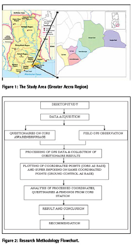
Study area
The study area is limited to a 25 km. Radius around the Accra CORS station in the Greater Accra Region. The Greater Accra Region of Ghana (Figure 3.1) is the smallest of all the ten administrative regions in the country. It is situated in the south-central part of Ghana and lies between latitudes 5° 30´ North and 6° 03´ North and longitudes 0° 30´ West and 0° 35´ East. It shares borders with the Eastern Region to the north, the Volta Region to the east, on the south by the Gulf of Guinea and Central Region to the west. It has a coastline stretching from Kokrobite in the west to Ada in the east. The region covers an area of about 3,245 square km. It is the second most populated region, after the Ashanti Region, with a population of almost 3 million. The Greater Accra Region currently harbours the seat of government in Accra.
The Region is predominantly a low-lying undulating coastal plain with heights scarcely reaching more than 250 feet above sea level except where the topography is broken by hills. On the north -eastern part of the region are the shai Hills which rise to about 1,000 feet. On the western end are the rounded low hills of between 400-500 feet found on the Togo series and the Cape Coast formations. A section of the Akwapim Ranges intrudes into the eastern half of the region with heights rising to about 700 feet.
The vegetation of the region is of the coastal savanna grassland type but occurring here and there within the savanna are thickets of forests along the stream courses and mangrove and swampy vegetation along the coastal lagoons. Along the piedmont of the Akwapim Ranges at the north-western section of the region can be found a gallery of forests and remnants of high forest vegetation.
The location of Accra and Tema in the region has made Greater Accra the industrial centre of the country. The region boasts of more than 200 major manufacturing industrial establishments which include an oil refinery mostly located in Accra and Tema. For this reason the region consumes about 46.5% out of the total electricity generated in the whole country. Accra and Tema are also the largest market area for the country’s manufactured products.
Materials used
Materials used in this study include:
▪ The Accra CORS used as reference for field GPS survey.
▪ Geodetic GPS receivers and processing software.
▪ Structures Questionnaires and Interviews.
▪ AutoCAD and ArcGIS for drawing and analyzing results
Coordinate systems used
Projected Coordinate System: – Accra_Ghana_ Grid (based on War Office spheriod)
Methodology
In this research, the use of questionnaires was deployed in conjunction with field observation (GPS observation using the CORS as the base station). A purposive sampling technique was used in questionnaire administration and feedback and vital information from the questionnaires were obtained and analyzed. The methodological steps is described in figure 2 and described below.
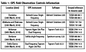
Desktop study
This involves assembling requisite materials needed for the project and a careful planning of questionnaire design and acquisition of field GPS data.
Questionnaires
The questionnaires were tailored towards getting enough information about the use of the Accra CORS established by the survey department of Ghana situated in 37. As such, the target groups were Geospatial data collectors therefore a purposive sampling approach was used in addition to structured questionnaire. The head of the GRN section and a staff were also interviewed.
Field GPS observation
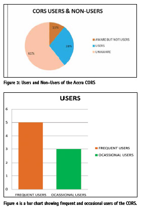
The field observation was performed based on the approved and frequently used differential positioning technique in Ghana. This technique was undertaken in post-processing mode. GPS data were acquired from different locations in Accra that are considerably within the CORS range. This range encompasses areas for which survey works are mostly done for cadastral plans preparation for title registration.
This is to test the results of processed GPS data using the CORS as reference station against the results gotten from processed GPS data using other ground controls as reference which in actual fact is still accepted by the Survey Department of Ghana. Most of these GPS survey works were carried with different survey instruments such as the Sokkia single frequency GPS, Ashtech single frequency GPS and the Topcorn dual frequency GPS.
After field data were acquired, a formal request was sent to the Accra GRN station on the 12TH day of April, 2016 requesting for reference data needed to process the field data on specific field observation dates. It is noteworthy that the CORS data was granted on the 25TH of April 2016 which is 13 clear days after the request was placed for it.
Data processing
The processing was done post-processed and was carried in two instances. The first processing was processing of the field data with the specific GPS brand of software where the ground control was used as reference in which the results were used to prepare cadastral plans. The second processing was processing of the field data with the GNSS 3.80 software where the COR station was used as reference. For compatibility reasons, the GPS field data was converted into Receiver Independent Exchange Format (RINEX) which is a data interchange format for raw satellite navigation system data using tools in the specific brand of GPS software so as to have all data in the same format for processing with single GNSS software.
Plotting
The post-processed coordinates of the various GPS field observation were plotted for a graphical appreciation and analysis. AutoCAD 2010 was used to plot the coordinates postprocessed from both ground control as reference in one case and the CORS as reference in the second case. ArcGIS 10.2 was also used to add a more graphical touch to the AutoCAD drawing and present the opportunity to do good analysis. The results of the plotting are shown in the following section.
Results and analysis
This chapter presents and discusses the results obtained in the study. The discussions focuses on the positional reliability of the Accra CORS data for post-processing differential GPS survey in Greater Accra region of Ghana. This analysis is done relative to field GPS data for post-processing differential GPS survey in Greater Accra where controls are used as references.
Field GPS data processing (ground control reference)
The reference coordinates used for the various survey works are based on the Ghana Grid system.
Results from questionnaires
A total number of 30 questionnaires were administered out of which 28 were received back. The categorization of sampled respondents includes private Professional surveyors in the Ghana Institution of Surveyors (GhIS). Figure 3.2 shows a chart of Users and Non users of the Accra CORS from respondents.
The results show that:
▪ 61% professionals are unaware of COR stations availability in the Greater Accra for GPS survey works and other GNSS applications at all.
▪ 39% professionals are aware of COR stations availability in the Greater Accra for GPS survey works and other GNSS applications.
▪ 28% professionals out of 39% of those who are aware from the collated answered questionnaires, have used the COR stations for their GPS surveys.
▪ Similarly 11% of these 39% professionals who are aware of the COR station, are outright nonusers for any of their GPS survey works.
Figure 4 is a bar chart shown frequent and occasional users of the Accra CORS
▪ Regular/Frequent users of the Accra COR station constitute 17.5% out the total number users. These professional surveyors use it to carry out most of their survey works within the allowable threshold of 100km further from any CORS within Greater Accra Region.
▪ A sizeable 10.5% of those interviewed seldom uses the Accra GRN or any other COR station in Greater Accra because they are either not aware of the availability of COR or they do not know the functional capability of COR station in their various GPS survey works.
Some of the general comments made by some of these professional surveyors who are either aware and does not use CORS include:
▪ The Lack of adequate and sufficient publicity from the Survey Department about the usefulness of the COR station in GPS surveys.
▪ The lack of alternate power generating plant for the Accra COR station giving rise to loss of reference data at times when they are most needed.
▪ The cumbersome, bureaucratic and time wasting nature of the managers of the COR station compelling them to give preference to the readily available ground control station for their GPS surveys.
▪ The unavailability of a quick mechanism of obtaining such reference data without coming to the Survey Department.
▪ Some also raised issues of not being abreast with the technological advancement and therefore find it difficult to do the data processing on their own. They therefore rely on other professionals to get their GPS survey works processed and most of the time, these reliant professional are not always available to help them hence the need to resort to the use of ground controls which is relatively faster for data post-processing.
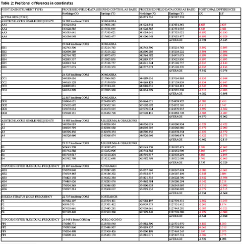
Positional differences in proccessed coordinates by the differing bases
The differences in the coordinates obtained through the use of CORS data for differential GPS positioning as against using other ground controls is shown in Table 2
Composite plans of results
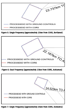
Figure 5 and Figure 6 shows composite plans from results obtained using CORS and from other ground controls within distances less than 25 kilometers from the CORS.
From the results of observations taken approximately 23 kilometers range away from the Accra COR station, results showed that an average of -2.344 feet change in Northings and -0.834 feet change in Eastings was obtained for Bortianor with a single frequency Sokkia Stratus GPS with an occupation time of 20 minutes. Likewise an average of -2.234 feet change in Northings and -1.664 feet change in Eastings was obtained for Achiaman using the a dual frequency Topcon hyper plus GPS with an occupation time of 4 minutes. Comparatively, both Northings and Eastings shows a remarkable similarity in change in Northings and a slight difference in the change in Eastings. The changes are relatively minimal and acceptable for preparation of cadastral plans in conformity with the standards of GPS surveys in Ghana as stipulated by the Technical Guidelines of Survey in Ghana. This gives room to say that even with an increased occupation/observation time within such a range away from the Accra COR station, finer results are bound to be achieved which makes the Accra COR station very good to use for GPS survey works in cadastral plan preparation and other GPS survey related works over such a distance.
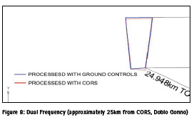
Figure 7 and 8 shows composite plans for distances at approximately 25 kilometers from the Accra CORS.
From the results obtained at approximately 25 kilometers away from the Accra COR station, an average of -4.082 feet change in Northings and -0.898 feet change in Eastings was obtained for Domiabra with a single frequency Ashtech Locus GPS with an occupation time of 25 minutes. Likewise an average of -4.522 feet change in Northings and 1.098 feet change in Eastings was obtained in Doblo Gonno using the a dual frequency Topcon hyper plus GPS with an occupation time of 5 minutes. Comparatively, both Northings and Eastings shows a remarkable similarity in change in Northings and a slight difference in the change in Eastings for both single and dual frequency GPS observations. The changes are relatively minimal in the in Easting as compared to the change in Northings. However, this presents the opportunity to say that even with an increased occupation/ observation time within an approximate 25 kilometers range away from the Accra COR station, finer results are bound to be achieved which makes the Accra COR station very good to use for GPS survey works in cadastral plan preparation and other GPS survey related works even over such a distance.
It is identified that, over a range of either 23km or 25km away from the Accra CORS, there is a consistent change in the position relative to positions processed using ground controls as base and in as much as these positions of points are safe for the preparation of cadastral plans accepted by the Survey Department, the CORS can also be used in that regard as well. Mindfully, the Accra COR station was established with a range of 100 km for any GPS survey undertaken. Since Accra is not beyond 26 km, then all GPS survey in Accra can be carried out using the Accra CORS as base. Based on such results, the CORS station can guarantee a system of homogenous and consistent coordinates which the using the ground controls as base may not guarantee. As GPS usage with respect to ITRF also guarantee plate tectonic movement detection and compensation, in case of any future shifts in coordinate systems GPS surveys conducted with the COR station as a reference could accommodate and ascertain such shifts which cannot be guaranteed in the case of using the ground controls as base.
Conclusion
The study aimed at exploring the use of CORS for GPS survey in Greater Accra through participatory/interview analysis coupled with Field GPS survey of some parts of the capital city of Accra.
The research questions that this study seeks to uncover in relation to the findings from this research includes:
What are the advantages of CORS usage for GPS survey?
The first obvious answer to this question is the fact that the CORS guarantees a homogeneous differentially corrected coordinates from GPS observations in addition to acting as a Control framework. It was also determined that positional differences though at times minimal existed between results processed using the CORS and those from existing ground controls for which observations have been made about their non-homogeneity. The results showed changes in the Northings and Eastings for both single and dual frequency as 2.344 feet,-0.834feet and 2.234feet,-1.664feet respectively over an approximate range of 23km away from the Accra COR station. It goes further to show that over an approximate distance of over 25 km away from the Accra COR station, the change in Northings and Eastings of both single and dual frequency observations are -4.082feet, -0.898feet and -4.522feet, 1.098feet respectively.
What are the limitations of CORS usage for GPS survey?
The results gathered from the questionnaires raised concerned limitations about the Accra COR station including:
▪ The lack of a backup battery system or energy generating system as a stand-by for the Accra COR station. This poses serious limitation in the collection of reference data for post processing of field data.
▪ The Lack of adequate and sufficient publicity from the Survey Department about the existence, operationality and usefulness of the COR station in GPS surveys.
▪ The cumbersome, bureaucratic and time wasting nature of the managers of the COR station compelling to give preference to the readily available ground control station for GPS surveys.
▪ The more time needed to be spent on the observation time at any range of 12 km away from the Accra COR station as gathered through the questionnaires/ interviews from personnel responsible for managing the Accra COR station.
▪ The unavailability of a ready system of transmitting reference data to users say by text or through the internet.
How can we remedy problems posed by using CORS for GPS survey?
This objective is highly imperative to the success and sustainability of the Accra CORS. Some of the suggestions to remedy problems posed by using the Accra COR station include:
▪ A shift of focus into giving adequate publicity of the Accra CORS at various levels ranging from the Ghana Survey Department, Ghana Institution of Surveyors (GhIS) and the Licensed Surveyors association.
▪ Making the Accra COR station more efficient by mobilizing capital and providing needing resources such as radio receivers and other technological equipment capable of enabling real time processing of GPS data.
▪ Setting up a more organized and concrete unit equipped with more expertise that will facilitate a quick response to CORS reference data to drive surveyors to explore it usage in their GPS survey works.
▪ Mobilizing resources to establish an ultra-modern power generating plant to assist in the reference data recording process in a non-stop fashion to make data available at any time, any day and every day.
References
▪ Afrifa, Akwasi Acheampong, (June, 2008). Developing a Differential GPS (DGPS) Service in Ghana. Kwame Nkrumah University of Science and Technology, Kumasi College of Engineering, Department of Geomatic engineering.
▪ Ali I. Naibbi, Samir S. Ibrahim (2014). An Assessment of the Existing Continuously Operating Reference Stations (CORS) in Nigeria: An Exploration Using Geographical Information System (GIS),Unublished Thesis.Department Geography University of Portsmouth, Portsmouth, UK.
▪ Ayer J, C Fosu (2008). Map Coordinate Referencing and the use of GPS datasets in Ghana.
▪ Journal of Science and Technology, Vol. 28, No. 1, April 2008 6.
▪ Yaw Poku-Gyamfi and Torben Schueler, (May 2008), RENEWAL OF GHANA’S GEODETIC REFERENCE NETWORK
▪ Poku-Gyamfi Y, G. W Hein (2006). Framework for the Establishment of a Nationwide Network for GNSS – A cost Effective Tool for Land Development in Ghana.
▪ Leick, A. (2004). GPS Satellite Surveying, third Edition, 2004, 435 pages, J. Wiley & Sons, ISBN 0-471-05930-7.
The paper was presented at FIG Congress 2018, Istanbul, Turkey, 6-11 May 2018.


 (1 votes, average: 3.00 out of 5)


Leave your response!