
| Applications | |
Citizen science tree inventory
The purpose of this paper is to present the approach of using the GeoTrees system, an integrated mobile data collector embedded with Quick Response (QR) code technology, to support a citizen-based tree inventory |
 |
|
 |
|
 |
|
Citizen science programmes have been conducted for several decades to make use the collective intelligence of local people in supplying scientific data. In developed countries, volunteer efforts to update urban street tree records have been common due to the recent advancement and low cost of mobile technology. In Malaysia, motivation to conserve the green space through replanting trees is soaring due to various campaigns at schools and in the community and corporate sectors. However, limited resources to conduct a tree inventory after planting or replanting events have led to difficulty in monitoring the conditions of trees that have been planted. Therefore, the purpose of this paper is to present the approach of using the GeoTrees system, an integrated mobile data collector embedded with Quick Response (QR) code technology, to support a citizen-based tree inventory. This system offers a low-cost solution in tree inventory whereby any mobile-enabled citizens could participate in tagging trees using their own Smartphone. End users are able to record basic tree data, including species name, diameter and height after tagging a tree with a QR code. The system also provides a tool to report post event activities such as tree watering and pruning. As a conclusion, engaging citizens in tree inventory using digital mobile technology could offer an alternative way to support in providing supplementary data toward a comprehensive database for monitoring the sustainability of urban green space and forest in Malaysia
Introduction
Most people love to live in a natural environment compared to the packed and unhealthy environment found in urban areas. The concept of green campus, city and resident existence is evidence on how people love to stay among nature. Nevertheless, this concept cannot beat the wonder of natural forest. Natural forest can promote healthy lifestyle (Elmendorf, 2008) and even improve human happiness.
Many campaigns to preserve and conserve forest have been conducted around the globe, the most popular is tree planting. Various organisations, corporate companies, schools and authorities have actively implemented tree planting. However, such organisations, companies and schools only care about planting the trees, not monitoring them. This is due to limited time and resources to conduct a tree inventory after planting events. As a result, the young trees soon wither and die.
Forest and urban forest management requires an inventory, as agreed by Bond and Buchanan (2006), Andreu et al. (2009) and Woodall et al. (2015). Without tree inventory, it is difficult to conduct monitoring of the planted trees, such as tracking a tree’s survival and growth. Implementation of tree inventory for tree management has been carried out for a long time (Bassett, 1976; Tate, 1985) by many organisations, research groups and even individuals. Trees data collected in a tree inventory can help organisations, researchers and stakeholders to analyse, understand and plan for a better future with minimum effect on the environment. These data can be used for charting trees’ status and diversity (Raupp et al., 2006; Sjöman et al., 2012; USDA, 2014), monitoring carbon sequestration (Chave et al., 2005; Feldpausch et al., 2012; Herold & Skutsch, 2011), combat pests and diseases in urban trees (Vecht, 2014) and monitor forest fire risk (De Longueville, 2009).
Tree inventory has been implemented by many projects, either by professional individuals and organisations or by nonprofessional citizens through volunteered geographic information (VGI). Several studies, for example by, Butt et al. (2015), Kitahara et al. (2010) and Roman et al. (2017) have involved non-professional citizens in tree inventory and data collection. Butt et al. (2015) used indigenous peoples’ field measurement to assess carbon stock in Amazonian Guyana and inexperienced undergraduate students were involved in Kitahara et al.’s (2010) study for tree data collection, while Kitahara et al. (2010) used volunteers as citizen scientists who were trained for roughly six to seven hours in urban tree inventory. This study proposes the use of non-professional citizens to maintain the trees and contribute data using GeoTrees application, a tree inventory application that collects tree data using Smartphones and updates information in real time.
Inventory and monitoring using GeoTrees
GeoTrees application
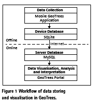
This study is motivated by the vision that tracking tree growth can be conducted using a low-cost mobile tree collector. Tree data can be provided by citizen scientists involved in the programme. To realise this vision, this study implements tree inventory and monitoring using an application called GeoTrees. GeoTrees application consists of two parts: (1) Mobile GeoTrees, which acts as a mobile data collector, and (2) GeoTrees Portal, which visualises, analyses and interprets the data for public use. Mobile GeoTrees saves the data into the device database and syncs it to the database server via the Internet. Figure 1 shows the workflow of the GeoTrees process in storing data.
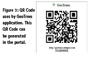
GeoTrees application uses Quick Response (QR) Code as an identification tag that can be generated in the GeoTrees Portal. These generated identification tags store the unique identity (ID) for each tree. During the planting process, this tag will be tied on the tree’s trunk and stored to the database using Mobile GeoTrees application. Data of tree size (i.e. tree names, diameter and height) and auxiliary data are included in this data collection and the data will automatically appear in the GeoTrees Portal. Using the ID tag, citizen scientists can monitor and update the tree data while the public can check the details of the trees.
Quick response codes
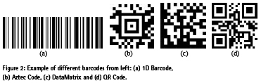
Teaching machines to read common textual documents is a complex challenge. This is because of the variety of fonts, styles and language in which the text can be written. To overcome this problem, George Laurer has created a code (Weightman, 2015) which based on Woodland and Silver’s patent of an automatic classifying apparatus and method that classifies things using photo-response to line method, subsequently known as barcode. This technique is a linear or one-dimensional (1D) barcode that can be read by machines quickly and easily. Using barcode, there is less issue of the fonts and styles as the bar or parallel lines represent as characters based on width and spacing. Figure 2 shows the examples of barcode.
In 1994, the Japanese company Denso- Wave introduced Quick Response (QR) Code (Rouillard, 2008), a two-dimensional (2D) barcode. It was initially used for high speed content decoding for inventory tracking of vehicle parts by the same company. The 2D barcode is classed into two classes, stacked (i.e. PDF 417) and matrix (Aztec Code, DataMatrix (SemaCode) and QR Code) (Rouillard, 2008). However, QR Code is more popular, especially in Asia. This is because it is lowcost, easy to implement and easy to use. Any device with a camera can be used as a QR Code reader as long as it been installed with QR Code software or tool. Even though RFID and NFC technologies are considered latest generation, they require a special dedicated device to operate or read (Falas & Kashani, 2007). Figure 3 shows the QR code used in this study.
The uniqueness of QR Code is the capability to encode Japanese Kanji characters (Falas & Kashani, 2007) and error correction capabilities (Rouillard, 2008). QR Code encodes information into five data modes (Barrera et al., 2013; Denso Wave, 2017) which are numeric, alphanumeric, byte/binary, Kanji and data bits (mixed). The Kanji data mode makes it convenient to use in Japan. Error correction capabilities ensure data can be restored even when substantial parts of the code are distorted or damaged (Rouillard, 2008).
GeoTrees Mobile Web Application
There are four main components of GeoTrees application as follow;
a) Register a new tree record
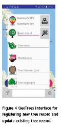
Registering a new tree requires locationbased data that can be automatically collected using a device’s Global Navigation Satellite System (GNSS) chipset built into the devices. Users are required to provide certain data, such as a tree ID (by scanning the QR Code tag), tree name, tree diameter, tree height, date planted and tree image. Once submitted to the system, the tree’s record will be available online at GeoTrees Portal for viewing. Figure 4 shows the main user interface of GeoTrees mobile application.
b) Update existing tree record
Updating existing tree records uses the same interface and collects the same data. However, not all data need to be updated. Users can update only several data that are capable to obtain and provide. The updated data will be stored separately from existing data, but will show as new updated data in the portal.
c) Maintain and monitor a tree
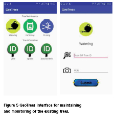
Maintaining and monitoring the trees requires users to go to the field. Users may conduct the maintenance activities for the tree, such as watering, fertilising and pruning. After every activity, users are required to record such activities using the Mobile GeoTrees application (see Figure 5). This process is to inform GeoTrees that such activities have been conducted by the user. Tree mortality can be recorded in a tree maintenance module. The dead trees will be removed from map viewer in the GeoTrees Portal. However, the data are still accessible in the data table. That means that replacing the dead tree with a new one on the same spot requires registering a new record.
d) GeoTrees Portal
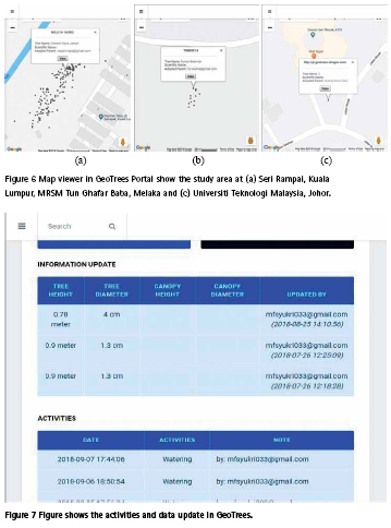
All the recorded trees are stored in the database server and can be viewed in GeoTrees Portal. Using Google Maps API, all tree records are shown in the interactive map which presents the location based on the ground. Figure 6 shows the three case studies that have implemented the GeoTrees application, which are Seri Rampai, Kuala Lumpur, MRSM Tun Ghafar Baba, Melaka and Universiti Teknologi Malaysia, Johor.
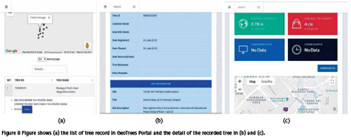
The data can also be viewed in detail in tabular form (see Figure 7). This function makes it easier to understand. Figure 8 (a) shows the list of trees that have been recorded in GeoTrees. This list can be filtered based on tree ID, tree name and plot name. Users can search for tree ID directly in the search section. Figure 8 (b) and Figure 8 (c) show the individual tree detail of the selected tree.
In the additional information page, detailed activities and information update logs are shown. This log is the record of activities conducted by users and acts as review material for users. Users’ latest activities will be shown in table with information on what activities have been done and when.
Using GeoTrees application, the group leader can monitor the public users’ activities and work performance in near real time. The log shows how the trees are treated and what is the status by just a few clicks.
Case study
Tree Planting at Universiti Teknologi Malaysia, Johor
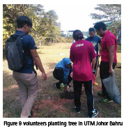
Universiti Teknologi Malaysia (UTM) Johor Bahru Campus has implemented the GeoTrees application in its tree planting programme. This programme is running under the myTREEvolution and UTM Campus Sustainability (UTMCS) campaigns’ to promote sustainable lifestyle among university students. This campaign objective is to reduce air pollution, to promote a healthy lifestyle and to improve environmental awareness among the campus community. Figure 9 shows the event in UTM.
This programme was conducted on 22 February, 29 March and 30 April 2018 for tree planting while maintenance and monitoring are still running continuously. In total, 276 trees were planted throughout the campaign in the four zones. Figure 6 (c) shows maps of trees planted at one of the four zones. Among the 276 trees planted, five shrubs died and another seven Hopea Odorata species were injured due to garden maintenance.
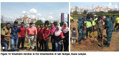
Eco Volunteerism at Seri Rampai, Kuala Lumpur
The International Education Peace Camp: Eco Volunteerism campaigns was conducted by the Kuala Lumpur Jungle Ambassador. This campaign was conducted in two phases, which involved volunteers from several schools from all over Malaysia. This campaign aims to nurture interest among students in conserving and preserving nature. The first phase involving 110 primary school student volunteers was held from 16-18 April, 2018 and the second phase was held on 25 August, 2018, which involved primary and secondary school student volunteers. In total, 110 trees have been planted in the first phase of the campaign, which also involved help from the US Navy volunteers.
In this event, participants were introduced to a sense of care and respect for our planet’s resources and how to participate and move proactively toward a green environment via planting a tree. All planted trees were registered in the GeoTrees application. Figure 6 (a) shows the map of the planted trees during this campaign. The map may help in recording and monitoring the green area and can be used to calculate how much carbon is reduced by planting trees. Trees will become a necessary asset to sustain the connectivity of green area, improving biodiversity shelter and securing the forest species.
Tree Planting at MRSM Tun Ghaffar Baba
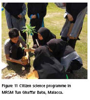
Tree planting activity at MRSM Tun Ghaffar Baba, Malacca is part of an activity conducted under the Geospatial Across the Community programme. This activity was held on 9 April, 2018. This activity was conducted to encourage students in taking part in citizen science programmes. The volunteers were taught on how to plant and maintain the trees and monitor the trees’ progress using GeoTrees application. This citizen science event involved 85 students of MRSM Tun Ghaffar Baba. Through this activity, the students gained knowledge on tree planting and maintenance, and how to reduce carbon footprint. Figure 11 shows the event in Malacca.
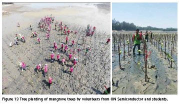
Mangrove Replanting at Pantai Cahaya Negeri, Negeri Sembilan
ON Semiconductor, Senawang, in collaboration with the Forestry Department of Peninsular Malaysia, Universiti Malaya (UM) and Universiti Teknologi Malaysia, has conducted a mangrove replanting event called Lestari Bakau 2018 to promote awareness on mangrove degradation in Malaysian waters. In total, 800 Rhizophora Mucronata were planted at Pantai Cahaya Negeri, Negeri Sembilan with participants involving volunteers from the ON Semiconductor and students from UM and UTM and Port Dickson Polytechnic.
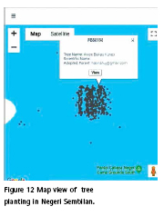
GeoTrees application was used to record and monitor the newly planted mangrove trees. In this event, all participants were divided into groups and each group planted 160 Rhizophora Mucronata. All trees were tagged with QR Codes ID for monitoring in the future. Figure 12 shows the map of newly planted trees during this event and Figure 13 shows the snapshot during the event.
Conclusion
The urban forest and green space require constant monitoring, hence, a systematic tool to register and update tree inventory is essential before further analysis can be made. This paper presents the approach of using an integrated mobile data collector embedded with Quick Response (QR) Code technology to support a citizen-based tree inventory. This system offers a lowcost solution in tree inventory whereby any mobile-enabled citizen could participate in tagging trees using their own Smartphone, although the accuracy of tagged trees is subject to certain positioning errors that might not be able to represent exactly the location of an individual tree. End users are able to record basic tree data, including species name, diameter and height, after tagging a tree with a QR code
The system also provides a tool to report post-event activities such as tree watering and pruning. In conclusion, engaging citizens in tree inventory using digital mobile technology could offer an alternative way to support in providing supplementary data toward a comprehensive database for monitoring the sustainability of urban green space and forest in Malaysia.
Acknowledgement
The authors would like to thanks the Ministry of Education through Mytreevolution iCSR, Kelab Duta Rimba Kuala Lumpur, LA 21 NGOs, MRSM Jasin Melaka, UTM Campus Sustainability, ON Semiconductor, Universiti Malaya and Forestry Department to support this study. This study is also supported by the Ministry of Education Malaysia and Universiti Teknologi Malaysia through the grant awarded to the authors (GUP grant 17H13).
References
Andreu, M. G., Brown, E. M., Friedman, M. H., Northrop, R. J., and Thornhill, M. E., 2009. Comparison of Urban Forest Inventory and Management Software Systems. University of Florida IFAS Extension, pp. 1–13.
Barrera, J. F., Mira, A., and Torroba, R., 2013. Optical Encryption and QR Codes: Secure and Noise- Free Information Retrieval. Optics Express, 21 (5), pp. 5373-5378.
Bassett, J. (1976). Tree-Inventory Systems for Human Settlements. In: Andresen, J. (Ed.) Trees and Forest for Human Settlements. International Union of Forest Research Organisations. Universiti of Toronto, pp. 2-14.
Bond, B. J., and Buchanan, B., 2006. Tree Inventories: Objectives and Tactics. Arborist News (International Society of Arboriculture), pp. 12–16.
Butt, N., Epps, K., Overman, H., Iwamura, T., and Fragoso, J. M. V., 2015. Assessing carbon stocks using indigenous peoples’ field measurements in Amazonian Guyana. Forest Ecology and Management, 338, pp. 191-199.
Chave, J., Andalo, C., Brown, S., Cairns, M. A., Chambers, J.Q., Easmus, D., Foelster, H., Fromard, F., Higuchi, N., Kira, T., Lescure, J.P., Nelson, B.W., Ogawa, H., Puig, H., Riera, B., Yamakura, T., 2005. Tree Allometry and Improved Estimation of Carbon Stocks and Balance in Tropical Forests. Oecologia (Berlin) 145, pp. 87-99.
Denso Wave, 2017. Information Capacity and Versions of the QR Code, Retrieved September 2, 2018, from http://www. qrcode.com/en/about/version.html
De Longueville, B., Smith, R.S., and Luraschi, G., 2009. “ OMG , from Here , I Can See the Flames !”: A Use Case of Mining Location Based Social Networks to Acquire Spatio- Temporal Data on Forest Fires. Proceeding of the 2009 International Workshop on Location Based Social Network, November 3, 2009, Seattle, Washington.
Elmendorf, W., 2008. The Importance of Trees and Nature in Community: A Review of the Relative Literature. Arboriculture and Urban Forestry. 34(3), pp. 152–156.
Falas, T., and Kashani, H., 2007. Two- Dimensional Bar-Code Decoding with Camera-Equipped Mobile Phones, Fifth Annual IEEE International Conference Pervasive Computing and Communications Workshops (PerCom), pp. 597 – 600.
Feldpausch, T.R., Lloyd, J., Lewis, S.L., Brienen, R.J.W., Gloor, M., Monte-agudoMendoza, A., 2012. Tree height integrated into pantropical forest biomass estimates, Biogeosciences, 9, pp. 3381–3403
Herold, M., and Skutsch, M., 2011. Monitoring, Reporting and Verification for National REDD+ Programmes: Two Proposals. Environmental Research Letters, 6 (1).
Kitahara, F., Mizoue, N., and Yoshiida, S., 2010. Effects of Training for Inexperienced Surveyors on Data Quality of Tree Diameter and Height Measurements, Silva Fennica, 44(4), pp. 657-667.
Raupp, M.J., Cumming, A.B., and Raupp, E.C., 2006. Street tree diversity in eastern North America and its potential for tree loss to exotic borers. Arboriculture and Urban Forestry, 32(6), pp. 297-304.
Roman, L.A., Scharenbroch, B.C., Östberg, J.P.A., Muellere, L.S., Henningg, J.G., Koeserh, A.K., Sandersi, J.R., Betza, D.R., and Jordan, R.C., 2017. Data quality in citizen science urban tree inventories. Urban Forestry and Urban Greening, 22, pp. 124–135.
Rouillard, J., 2008. Contextual QR Codes. Proceedings of the Third International Multi- Conference on Computing in the Global Information Technology (ICCGI 2008), Athens, pp. 50-55.
Sjöman et al., 2012. Diversity and Distribution of the Urban Tree Population in Ten Major Nordic Cities. Urban Forestry and Urban Greening, 11(1), pp. 31-39.
Tate, R., 1985. Uses of Street Tree Inventory Data. Journal of Arboriculture, 11(7), pp. 210-213. Tiwari, S., 2016. An Introduction to QR Code Technology. Proceedings of 2016 International Conference on Information Technology, pp. 39-44.
USDA, 2014. Forest Inventory and Analysis: Fiscal Year 2013 Business Report. FS1040. Washington.
Vecht, J. V., 2014. If a Tree Falls in the Urban Forest: Current and Future Pest Vulnerability in Toronto’s Urban Forest. Master Thesis. University of Toronto.
Weightman, G., 2015. The History of the Bar Code, Retrieved September 2, 2018, from https://www.smithsonianmag.com/ innovation/history-bar-code-180956704/
Woodall, C. W., Coulston, J. W., Domke, G. M., Walters, B. F., Wear, D. N.,Smith, J. E., Andersen, H., Clough, B. J., Cohen, W. B., Griffith, D. M., Hagen, S. C., Hanou, I. S.,Nichols, M.C., Perry, C. H., Russell, M. B., Westfall, J. A., and Wilson, B. T., 2015. The U.S. Forest Carbon Accounting Framework : Stocks and Stock Change 1990-2016, General Technical Report NRS-154.


 (4 votes, average: 3.50 out of 5)


Leave your response!