
Articles in the Surveying Category


Climate change has been one of the main causes of the rise and fall of civilisations, migration and destruction of complex societies from the apocalyptic story of Noah’s Ark and the flood, through the ice age to the present time. The development of complex societies and population…

The Federal Territory of Putrajaya (Putrajaya) is the administrative capital of the Malaysian Federal Government with an area of 4931 hectare. It is divided into 20 precincts and consists of 10,580 land parcels…
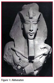
During his relatively short reign of 17 years the highly controversial pharaoh of ancient Egypt derogatorily described as “The Heretic King” caused the most disruptive religious upheaval of the entire period of the legendary civilisation. Akhenaten took the throne of New Kingdom…

Each community has the duty to conserve, identify and properly manage its own heritage that, unfortunately, is often susceptible to transformations due to time, anthropogenic factors or damages caused by natural phenomena. Innovative geomatic techniques, when correctly integrated among them…

Modern geomatic techniques have provided interesting advantages in a wide range of research areas. However, the traditional surveying methodologies continue remaining essential in order to ensure reliable and precise results of any kind.

Stimulating interest and encouraging youth participation for future sustainability

The methodologies of land surveying remained largely unchanged over hundreds, if not thousands, of years. Computational methods were enhanced with the use of logarithmic tables introduced by Napier in the 17th century, and supplemented by hand-powered rotational cylinder mechanisms for speed of calculation first introduced by Pascal, also in the 17th century. These were later to be electrified in the 20th century prior to the invention of the…

The main goal of the new phenomenon is the participation of the citizens. Everyone can be involved by collecting and uploading data or by editing entries and monitoring the results. Different terms are interlinked to it; User Generated Content, Crowdsourcing and Neogeography are only a few of them share the main philosophy.

Through all of these changes, there have been some fundamental challenges that seem to me to be an ongoing part of academic life in any professional school. They are challenges that seem to confront many university surveying programs in the world. These and the solutions that we have adopted are the subject of this article.

Seven (7) of the nine (9) points which constitute the National GNSS Calibration Network were occupied using an active VRS receiver. This network of points will form the basis of legal traceability for Cadastral Surveys in Jamaica. The tables 4 and 5 below set out the results.


 (5.00 out of 5)