Articles in the Articles Category

As the world rages with debate,
About who is right,
And whose rights are endangered,
There unfolds a ‘humanitarian catastrophe’…
The death toll is mounting…
Where even babies have become most unfortunate victims,
Who are symbols of hope and happiness,
Who don’t and can’t take sides.
Humanity is paramount…
It must prevail!
Bal Krishna, Editor
bal@mycoordinates.org
Tweet
February 2024
Geo Week 2024
11 – 13 February
Denver, CO, USA
https://www.geo-week.com
MENA Geospatial Forum
14 – 15 February 2024
Dubai, UAE
https://menageospatialforum.com
March 2024
Geo Connect Asia
06 – 07 March 2024
Singapore
https://www.geoconnectasia.com
DGI 2024
11 – 13 March
…

In Ubiquitous dimensions, the notion of a “map” must be replaced with “mapping,” as users demand real-time creation and manipulation of maps in a digital society
PEPPLE, Godwill Tamunobiekiri
Department of Surveying and Geomatics, Faculty of Environmental Sciences Rivers State University Port Harcourt, Nigeria
UDOH, Ofonmbuk Jeremiah
Office of the Surveyor Genera Delta State, Asaba, Delta State, Nigeria
WEST, Emilia …

This paper provides a brief history of the RINEX format, presents examples of recent RINEX format versions and discusses the editing of RINEX observation files.
Dr Volker Janssen
Senior Technical Surveyor in the Geodetic Operations team at DCS Spatial Services, NSW Department of Customer Service, in Bathurst, Australia.
The Receiver Independent Exchange (RINEX) format is the international standard …

Alexander Wiechert
CEO at Vexcel Imaging in an interview with Coordinates at the launch of new Ultracam Aerial systems
Continuing the expansion of Ultracam universe, congratulations on the newly launched Ultracam aerial systems – Merlin 4.1 and Dragon 4.1. Please highlight few important features of both.
Thank you so much, we are …

Prof M S Swaminathan,
A plant geneticist, agronomist, agricultural scientist,
An advocate of sustainable agriculture,
A proponent of the use of technology in general, and geospatial in particular,
With a caution “not to worship technology, but the outcome one desires”,
And a key architect of India’s ‘green revolution’
Who also warned against ‘greed revolution’ A
nd …
November 2023
GEOINT Innovation Summit
1-2 November 2023
National Harbor, Maryland, USA
https://geoint.dsigroup.org
43rd INCA International Congress
6-8 November 2023
Jodhpur, Rajasthan.
https://43inca.org
Trimble Dimensions 2023
6-8 November
Las Vegas, USA
www.trimble.com
GoGeomatics Expo
6-8 November 2023
Calgary, …

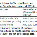
Land tenure security is a critical government service that has repercussions on agricultural productivity, housing development, business investment, and the development of urban areas. The present study presents a cost-benefit analysis of tenure security in Sub-Saharan Africa. Readers may recall that we published the first part of the study in September 2023 issue of Coordinates. …

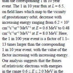
In this study, an extreme value analysis is condcuted of the daily average relativistic electron flux in GPS orbit as a function of position and energy using data from the US NS41 satellite from 10 December 2000 to 25 July 2020
Nigel P. Meredith
British Antarctic Survey, Natural Environment Research Council, Cambridge, United Kingdom
Thomas E. Cayton
Santa Fe, …

The disasters that recently hit Morocco and Libya
Are different in nature,
But they remain same in terms of deaths and devastations.
The victims, as generally happens in such situations,
Were largely left to fend for themselves
The trauma of the affected,
Though, will take a long time to heal,
The world is quick …


 (5.00 out of 5)