Articles in the GNSS Category
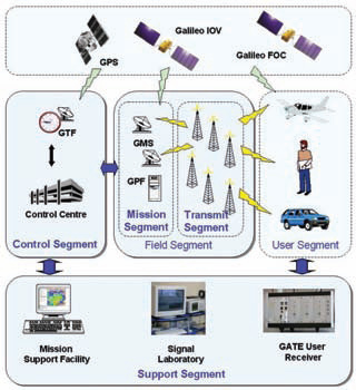
GATE is a ground-based realistic test environment for developers of receivers, applications and services for the future satellite navigation system Galileo. GATE is currently being builtup and as from beginning of 2008 – several years before Galileo becomes fully operational – Galileo signals will be emitted by 6 earth-fixed transmitters in the area of Berchtesgaden, located in the southeast of Germany in the German Alps. This will provide the opportunity for receiver, application and service developers to perform realistic field-tests of hardware and software for Galileo at an early stage. In this way GATE will also support German and European products for Galileo entering the market.
While the motivation of the US groundbased ranging test bed Yuma in the 70’s was to prove the concept of satellite navigation, no one doubts that Galileo will work from a conceptual point of view. However, it is still an ambitious technological project, introducing a signal structure far more sophisticated than the GPS C/A Code. In fact there are three major mission objectives to be covered by GATE – Signal Experiments, Receiver Testing and User applications.

Any look into the crystal ball of (even the near) future is fraught with caveats, error, and less than perfect clarity. However, certain extrapolations and not-so-wild guesses do exist.
GNSS, General – Existing (and near term proposed) systems will continue to expand, receive modernization support, and move (slowly) towards increased interest in securitizing systems and data utilized in the GNSS sourceto- user “food chain”. Nationalism of systems and (at least regionalism of) augmentation sources will progress.

There are lots of needs for a unified platform that allows efficient GNSS (Global Navigation Satellite System) receiver development and testing for various applications. With the current functionality of the GPS constellation and the promise of the future Galileo constellation, many efforts have been focused on the 1575.42MHz L1 signals for the GNSS software receiver implementation. GPS (Global Positioning System) L1 or Galileo E1…
In looking ahead at what milestones we may expect to see during 2008 in the world of GPS and GNSS it is easy to be caught at one of two extremes. The first extreme would be to make the mistake of the shortsighted person who in the late nineteenth century proposed that the US Patent Office should be closed because everything conceivable had already been invented. The other extreme would be to look ahead at the promise of new constellations…
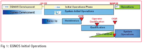
THIS paper describes of the activities performed by the European Satellite Services Provider (ESSP) and its partners in the establishment of the EGNOS system operations organization, the implementation and utilization of the operations processes and procedures and the operations products baseline as well as describing the management processes used within EGNOS operations with respect to preparation for Safety of Life Services.

ACCORDING to a recent Eurobarometer opinion survey, Europeans are highly positive about the GALILEO program, which aims to develop Europe’s own satellite-based navigation system. The survey indicates that most of EU citizens are aware of the role global positioning systems play in their everyday lives, know about possible applications and are firmly behind the development of such new technologies.
Furthermore, an overwhelming majority consider that Europe should set up an independent navigation system even if this involves securing additional public funds.
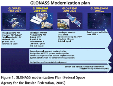
THE conventional geomatics industry including mapping and surveying applications has been revolutionized with the use of GPS, which is the best known, and currently fully operational satellite based navigation system operated by USA (Parkinson, and Spilker Jr., 1995). In the mean time, Russia also operates its own satellite based navigation system called GLONASS. The USA is modernizing GPS in order to retain its superiority in satellite based navigation technologies (MacDonald, 2002,). In order to keep up with USA’s progress in building next generation system, Russia is taking serious steps to modernize GLONASS as well (Federal Space Agency for the Russian Federation, 2005). The GPS and GLONASS signals are free but its availability is not guaranteed and currently most users are prepared to accept this risk (Parkinson, and Spilker Jr., 1995). However, as satellite navigation becomes a vital technology across a number of critical industrial sectors, the prospect of, for example, a nation’s transport infrastructure becoming dependent on this technology is a strategic risk that most industrial countries are not willing to accept. This argument initiated the Galileo program in Europe. Therefore, those systems form the mainframe of Global Navigation Satellite Systems (GNSS) (MacDonald, 2002,).
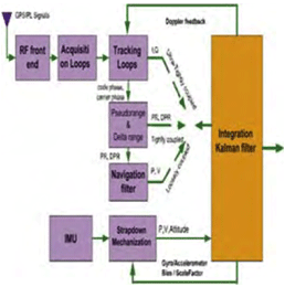
Inertial Navigation Systems (INS) are based on accelerometers and gyroscopes for position and attitude determination. Thus, INS is self-contained and autonomous. This makes INS an optimal option to be integrated with GPS, as both systems can complement each other to enhance positioning performance (Greenspan, 1996). On the one hand, the advantages of INS include high positioning (and attitude) update rates, and high short-term accuracy, both helpful in bridging the signal gaps between the GPS signal sampling epochs and the gaps due to signal outages. On the other hand, however, a major drawback of INS when operated as a stand-alone system is the time-dependent growth of systematic errors, which can be calibrated by GPS ranging measurements with consistent accuracy.
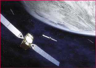
Exact determination of position, at any time, from any location, secure and precise navigation, efficient route planning – in the future it will all be summed up in one word: Galileo. This new European navigation system with 30 satellites will be ready for use in the beginning of the next decade. A first test satellite has been launched into its orbit in 2005. Another one will follow by the end of this year. Galileo will make civil users of satellite navigation in Europe and all over the world independent of the American Global Positioning System (GPS). Even more, especially in connection with civilian use, Galileo will outperform GPS and thereby open the gate for new applications and markets for satellite supported navigation. Especially in the combination with navigation, mobile telecommunication and information services, there is an immense utilisation and market potential.

GPS has demonstrated a stellar performance ever since its inception. In fact the satellites typically operate beyond their expected lifetime which potentially creates obstacles to the timely modernization of the system. GPSGAP (GPS, Geodesy and Application Program) is an online educational initiative by the University of Maine that offers in-depth knowledge about this fantastic system and its uses.
My enthusiasm for GPS began when testing the experimental Macrometer receiver during the summer of 1982 at M.I.T. over a 30 km baseline from Woburn, MA, to Mount Watchusett. The satellite visibility ranged from about 6 p.m. to midnight in New England. Many of the sunset watchers at the summit were puzzled by my activities and impressed by the huge piece of equipment in the back of my station wagon, the abundance of cables, and the strange looking antenna (so they thought). Their puzzlement about what I was up to was refl ected in some of their comments, such as“Is this thing taking off?”, or “Are you on our side?” Of course, there was plenty of time until midnight to be entertained by Fourier transforms and such on the computer screen, and to ponder the unlimited potential of GPS. Whatever has evolved since those days in terms of civil uses of GPS needs no further explanation.


 (5.00 out of 5)